Waitaki District facts for kids
Quick facts for kids
Waitaki District
|
||
|---|---|---|
|
Territorial authority
|
||

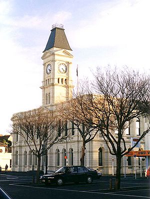
Waitaki District Council building, Thames Street, Oamaru
|
||
|
||

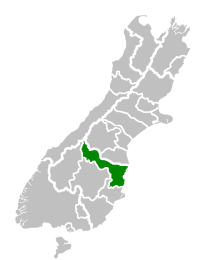
Location of the Waitaki District within the South Island
|
||
| Country | New Zealand | |
| Regions |
|
|
| Communities |
|
|
| Wards |
|
|
| Formed | 1989 | |
| Seat | Oamaru | |
| Towns | ||
| Area | ||
| • Land | 7,107.94 km2 (2,744.39 sq mi) | |
| Population
(June 2023)
|
||
| • Total | 24,300 | |
| Time zone | UTC+12 (NZST) | |
| • Summer (DST) | UTC+13 (NZDT) | |
| Postcode(s) |
Map of postcodes
|
|
| Postcode(s) |
7977
|
|
| Area code(s) | 03 | |
| Website | Waitaki District Council | |
The Waitaki District is a special area in the South Island of New Zealand. It's like a local government region, managed by the Waitaki District Council. This district is unique because it stretches across two different regions: Canterbury and Otago. The main town and where the council is located is Oamaru.
Contents
Exploring Waitaki's Landscape
The Waitaki District covers a large area of about 7,152 square kilometers. A big part of it (almost 60%) is in the Canterbury Region, and the rest (about 40%) is in the Otago Region. This makes Waitaki the only district in the South Island that belongs to two regions!
Why is Waitaki in Two Regions?
The main reason for this split is the Waitaki River. This river forms a natural boundary between Canterbury and Otago. Because there are important power projects (hydro schemes) on the river, it was decided to put the entire river area under one administration. This created the unique split you see today. Even with this split, some people in the Canterbury part of Waitaki still feel a strong connection to Otago.
What Does the Land Look Like?
The district is mostly made up of wide, flat land created by the river. It stretches inland along the riverbanks, forming a shape that looks a bit like a triangle. This area is mostly used for farming.
People and Communities of Waitaki
The Waitaki District is home to about 22,300 people. Most of these people, around 13,800, live in Oamaru, which is the biggest town and the district's main center.
How the District Was Formed
The Waitaki District was created in 1989. Before that, it was made up of several smaller areas: Waitaki County, Waihemo County, and Oamaru Borough. These areas joined together to form the district we know today. The Waitaki District Council is in charge of running the district.
Waitaki's Economy: Farming and More
The Waitaki District is not very crowded, and it has many farms. Farming is a very important part of the local economy.
Changes in Farming
In recent years, there have been discussions about new types of farming. Some people worry that big companies might take over family farms. They are also concerned about how these large farming operations could affect the local environment.
Who Lives in Waitaki? A Look at the Population
The Waitaki District had a population of 22,308 people when the census was taken in 2018. This was an increase of about 7% since 2013.
Age and Gender in Waitaki
In 2018, there were slightly more females than males. The average age of people in Waitaki was 45.6 years. About 18% of the population was under 15 years old, and about 23% was 65 or older.
Different Backgrounds and Cultures
Most people in Waitaki (around 88%) are of European/Pākehā background. There are also people from Māori (8.2%), Pacific (3.8%), and Asian (5.3%) backgrounds, along with other ethnicities. About 15% of the people living in Waitaki were born outside New Zealand.
Beliefs and Work
When it comes to religion, about 48% of people said they had no religion, while 41.5% were Christian. Other religions were also present. For work, about 47% of people aged 15 or older had full-time jobs, and 15.5% worked part-time.
Towns and Settlements in Waitaki
Oamaru is the largest town in the Waitaki District, with over 13,000 residents. It's the heart of the district.
Other Places to Explore
The district has many other smaller towns and communities. Here are some of them, grouped by the different wards (local areas) within the district:
- Ahuriri Ward:
- Aviemore
- Benmore
- Clearburn
- Kurow
- Ohau
- Lake Waitaki
- Lindis Pass
- Omarama
- Otekaieke
- Otematata
- Otiake
- Wharekuri
- Strachans
- Oamaru Ward:
- Waihemo Ward:
- Billys Flat
- Dunback
- Flag Swamp
- Glenpark
- Goodwood
- Green Valley
- Hampden
- Hillgrove
- Inch Valley
- Kaika
- Katiki
- Macraes
- Makareao
- Meadowbank
- Moeraki
- Moonlight Flat
- Morrisons
- Nenthorn
- Palmerston
- Pleasant Valley
- Shag Point
- Shag Valley
- Stoneburn
- Trotters Gorge
- Waianakarua
- Waihemo
- Wairunga
- Waynes
- Puketapu
- Corriedale Ward:
- Canterbury section:
- Black Point
- Bortons
- Danseys Pass
- Duntroon
- Earthquakes
- Kokoamo
- Livingstone
- Maerewhenua
- Waikaura
- Pukeraro
- Otago section:
- Airedale
- Awamoko
- Cormacks
- Corriedale
- Elderslie
- Enfield
- Five Forks
- Fuchsia Creek
- Georgetown
- Herbert
- Hilderthorpe
- Incholme
- Island Cliff
- Island Stream
- Kakanui
- Kauru Hill
- Kia Ora
- Kuriheka
- Maheno
- Marakerake
- Maruakoa
- Ngapara
- Otepopo
- Papakaio
- Peebles
- Pukeuri
- Queens Flat
- Reidston
- Richmond
- Rosebery
- Tapui
- Taranui
- Teschemakers
- Tokarahi
- Totara
- Waimotu
- Waitaki Bridge
- Whitecraig
- Whitstone
- Windsor Park
- Windsor
- Maraeweka
- All Day Bay
- Canterbury section:
 | Delilah Pierce |
 | Gordon Parks |
 | Augusta Savage |
 | Charles Ethan Porter |


