Duntroon, New Zealand facts for kids
Quick facts for kids
Duntroon
|
|
|---|---|
|
Town
|
|

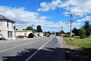
Campbell St (State Highway 83), the main street
|
|
| Country | New Zealand |
| Region | Canterbury |
| Territorial authority | Waitaki District |
| Ward | Ahuriri Ward |
| Community | Ahuriri Community |
| Electorates |
|
| Area | |
| • Total | 5.13 km2 (1.98 sq mi) |
| Population
(June 2023)
|
|
| • Total | 110 |
| • Density | 21.4/km2 (55.5/sq mi) |
| Time zone | UTC+12 (New Zealand Standard Time) |
| • Summer (DST) | UTC+13 (New Zealand Daylight Time) |
| Postcode |
9445
|
| Local iwi | Ngāi Tahu |
Duntroon is a small farming town in the Waitaki District of New Zealand's South Island. Its name comes from the Scottish word "Dùn Treòin." Even though it's often thought of as part of North Otago, Duntroon is actually in the southern part of Canterbury.
The Waitaki River flows just north of Duntroon. This river used to be the border between two regions. Now, the official border has moved south. This means most of the Waitaki District, including Duntroon, is in Canterbury. The Maerewhenua River also runs to the east of the town.
Near Duntroon, you can find a cool rock formation called the Earthquakes. These are limestone cliffs.

The town was named by a Scottish farmer, Robert Campbell. For a long time, Duntroon's main activity has been farming. People mostly raise sheep and grow crops like wheat and barley.
Contents
Discovering Duntroon's Past
Duntroon is home to the Vanished World Heritage Centre. This center teaches visitors about the amazing geology of the Waitaki region. It also helps protect fossils of ancient animals found nearby.
Ancient Penguins and Rock Art
Some of the fossils found here include two types of ancient penguins. These are called Lowe's penguin and Lopdell's penguin. They were found in a special rock layer called the Kokoamu Greensand.
The town is also close to two very old Māori rock drawings sites. One of these is the Takiroa Rock Art Shelter. These drawings are hundreds of years old!
Filming Location: Narnia's Elephant Rocks
About 5 kilometers (3 miles) south of Duntroon, you'll find a group of huge rock formations. They are called "Elephant Rocks." These rocks were used as a filming location for the first Chronicles of Narnia movie in 2005. The rocks are on private land, but you can see them from the road.
Getting Around Duntroon
Duntroon used to be an important stop on a branch line railway. This railway eventually became known as the Kurow Branch. Duntroon was one of the few towns that had a railway station for the entire time the line was open.
The Railway's Journey
In 1875, the railway line from Pukeuri opened up to Duntroon. However, it stopped just outside Duntroon because it was hard to build a bridge over the Maerewhenua River. In 1878, work began on another line from Duntroon to Kurow.
On July 2, 1881, the bridge over the Maerewhenua River was finished. This connected Duntroon to the national railway network. On November 7, 1881, the line went past Duntroon. This meant Duntroon was no longer the end of the line.
The railway served the town for over 100 years. It finally closed in mid-1983. Today, the old railway station is a special place to stay for people who enjoy fishing or cycling. Near the station, you can still see an old water tank that was used for steam locomotives.
Cycling the Alps to Ocean Trail
Duntroon is also on the route of the Alps to Ocean Cycle Trail. This popular cycling path was approved in 2010 and built starting in 2011. It's a great way to explore the area on a bike!
Duntroon's Community
Duntroon is considered a rural settlement by Statistics New Zealand. It covers about 5.13 square kilometers (about 2 square miles). As of June 2023, Duntroon had an estimated population of 110 people.
Population Changes Over Time
| Historical population | ||
|---|---|---|
| Year | Pop. | ±% p.a. |
| 1996 | 117 | — |
| 2001 | 120 | +0.51% |
| 2006 | 99 | −3.77% |
| 2013 | 75 | −3.89% |
| 2018 | 96 | +5.06% |
At the 2018 New Zealand census, Duntroon had 96 people living there. This was an increase of 21 people since the 2013 census. The average age of people in Duntroon was 46 years old.
Most people in Duntroon (93.8%) are of European background. About 6.2% are Māori, and 6.2% are Asian. Many people in Duntroon (50%) said they had no religion. About 34.4% were Christian.
Learning in Duntroon
Duntroon School is a primary school for students in years 1 to 8. It opened in 1879. As of February 2024, the school has 88 students.
 | Delilah Pierce |
 | Gordon Parks |
 | Augusta Savage |
 | Charles Ethan Porter |

