Shag Point facts for kids
Quick facts for kids
Shag Point
|
|
|---|---|
|
township
|
|

Shag Point headland
|
|
| Country | New Zealand |
| Region | Otago |
| Territorial authority | Waitaki District |
| Ward | Waihemo Ward |
| Time zone | UTC+12 (NZST) |
| • Summer (DST) | UTC+13 (NZDT) |
| Local iwi | Ngāi Tahu |
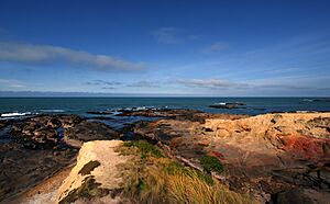
Shag Point / Matakaea is a cool place in East Otago, New Zealand. It's both a piece of land sticking out into the sea (called a headland) and a small community (a township). Both the headland and the nearby Shag River get their English name from a seabird. This bird is called the pied shag.
Contents
Exploring Shag Point / Matakaea
Shag Point is located along a single road. This road branches off State Highway 1. It's about nine kilometres northeast of a town called Palmerston. The road leads to the point itself, which is three kilometres southeast of where it starts.
What is a Headland?
The point is a hilly piece of land. It sits between a long, open bay called Katiki Beach and the mouth of the Shag River. This headland is part of the Matakaea Scenic Reserve. It's famous for its population of New Zealand fur seals. You can often see these amazing animals there!
History and Nature at Shag Point
Close to the headland, there's a very old Māori site. It's known as the Matakaea/Shag Point Occupation Site. This site is really important for understanding the history of the area. It's listed as a Category II site by Heritage New Zealand. This means it's a place with special historical or cultural value.
Amazing Geology of the Area
The rocks and land around Shag Point are very interesting to scientists. This area is a great example of something called the Katiki Formation. It's also where scientists found the bones of an ancient sea reptile! This reptile was a plesiosaur named Kaiwhekea katiki.
The area also has the oldest known ignimbrite deposit in the South Island. Ignimbrite is a type of rock formed from volcanic eruptions. This one is super old, about 112 million years old!
 | James Van Der Zee |
 | Alma Thomas |
 | Ellis Wilson |
 | Margaret Taylor-Burroughs |

