
Banks Peninsula facts for kids


Banks Peninsula is a special piece of land in New Zealand. It sticks out into the sea on the east coast of the South Island. This area was formed by old volcanoes. It covers about 1,165 square kilometres (450 square miles). The peninsula has two big harbours and many smaller bays. Christchurch, the largest city in the South Island, is right next to the northern part of the peninsula.
Contents
How Banks Peninsula Was Formed


Banks Peninsula is the biggest volcanic area in the South Island. It's more than twice the size of the older Dunedin volcano. This peninsula was made from two huge volcanoes that erupted a long time ago. The first one formed Lyttelton Harbour / Whakaraupō and the second formed Akaroa Harbour. These volcanoes were active between 8 and 11 million years ago.
At first, the peninsula was a group of islands far out at sea. The volcanoes were very tall, reaching about 1,500 metres (4,900 feet) above sea level. Over time, the land around them changed. The Canterbury Plains formed from rocks and dirt washed down from the Southern Alps. These plains grew until they connected the volcanic islands to the rest of the South Island. The hills between Lyttelton Harbour and Christchurch are called the Port Hills.
Early History of Banks Peninsula
Who Lived Here First?
The first people to live on Banks Peninsula were the Māori people. Their stories say that the Waitaha tribe arrived first, led by their ancestor Rākaihautū. The Māori name for the peninsula is Te Pātaka o Rākaihautū. This means "The Storehouse of Rākaihautū." It shows how much food (like from the forests, sea, and rivers) was found here.
Later, the Kāti Māmoe tribe came, followed by the Ngāi Tahu tribe around the 1730s.
European Explorers Arrive
The first European to see Banks Peninsula was Captain James Cook in 1770. He was sailing around New Zealand. Cook thought the peninsula was an island and named it "Banks Island" after his botanist, Joseph Banks. He didn't explore it closely.
In 1809, Captain Samuel Chase on the ship Pegasus realised Cook was wrong. He found that "Banks Island" was actually a peninsula. The bay nearby, Pegasus Bay, is named after his ship.
Early European Settlements
In the 1830s, some European whaling stations were set up on Banks Peninsula. In 1838, a French whaler named Captain Jean François Langlois thought Akaroa would be a good place for a settlement. He bought some land from Māori chiefs. He then went back to France to find settlers.
However, by the time Langlois and his settlers arrived in August 1840, many Māori chiefs had already signed the Treaty of Waitangi. This treaty made New Zealand a British colony. The British Governor, William Hobson, quickly sent a ship, HMS Britomart, to Akaroa to make sure British rule was clear. The French settlers still set up their town in Akaroa. The British government later gave the French company some land in exchange for their claims to the peninsula.
Over time, Lyttelton and Christchurch grew much bigger than Akaroa. Today, Akaroa is a popular place for holidays and cruise ships. It still has many French influences and old buildings.
What Banks Peninsula is Like Today
Jobs and Money
- Fishing: People farm mussels in the sea off the coast.
- Farming: Raising animals and growing crops has always been important here.
- Tourism: After the big earthquakes in Christchurch in 2010 and 2011, many cruise ships started visiting Akaroa Harbour. This brought more visitors to the area.
The Summit Road
The Summit Road is a famous road on the peninsula. It follows the tops of the hills and offers amazing views. It's split into two main parts:
- One part runs along the top of the Port Hills, from Awaroa / Godley Head to Gebbies Pass.
- The other part goes around the edge of the old volcano crater above Akaroa Harbour.
This road is great for sightseeing, and there are parks and walking trails along the way.
Protecting Nature
Long ago, almost all of Banks Peninsula was covered in native forest. Now, less than 2% remains because of farming and settlement. But people are working to bring the native forest back.
- Hinewai Reserve: This is a private nature reserve that started in 1987. It's a huge area (1,250 hectares) where native trees are allowed to grow back. It has 40 km (25 miles) of walking tracks.
- Marine Reserves: A large area around the peninsula is a Marine Mammal Sanctuary. This helps protect Hector's dolphin, which is the smallest dolphin species. You can often see these playful dolphins in Akaroa. There are also two smaller marine reserves, Pōhatu Marine Reserve and Akaroa Marine Reserve, which protect sea life.
- Rod Donald Banks Peninsula Trust: This group works to create more walking and biking trails and improve nature on the peninsula. They are also working to buy land to create a new conservation park.
- Banks Peninsula Conservation Trust: This trust helps protect and improve the natural environment. They work with landowners to protect important areas forever.
Towns on Banks Peninsula
- Akaroa: A small town on the edge of Akaroa Harbour, known for its French history.
- Little River: A small town at the end of the Little River Rail Trail. It has art galleries and a primary school.
- Wainui: A settlement with many holiday homes on Akaroa Harbour. Its Māori name means 'big water' or 'big bay'. It was once a large Māori settlement.
- Duvauchelle: A small town at the very top of Akaroa Harbour.
- Diamond Harbour: A town located on the peninsula.
Bays of Banks Peninsula
Banks Peninsula has many beautiful bays. Here are some of them:
- Sumner Bay: This bay marks where the flat plains meet the rocky cliffs of the peninsula. It's part of Christchurch.
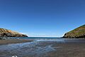
- Taylors Mistake: A popular swimming beach in Christchurch. It was once called Vincent's Bay. It got its current name after a ship called Hawk crashed there in 1853.
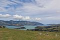
- Lyttelton Harbour / Whakaraupō: One of the two large harbours on the peninsula. It has two islands inside it: Ōtamahua / Quail Island and Ripapa Island.
- Port Levy: The most north-facing bay on the peninsula. Its Māori name is Koukourarata.
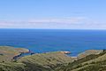
- Pigeon Bay: This bay has a walking track with great coastal views. It was likely named because of the many native pigeons (kererū) seen there long ago.
- Little Akaloa: Named "little" to tell it apart from Akaroa. Farming is important here, and camping is popular in summer.
- Okains Bay: Known for its holiday campground and a large sandy beach.
- Le Bons Bay: A quiet bay with a large, often empty beach. New Zealand Fur Seals sometimes play where the river meets the sea.
- Hickory Bay: Known for good surfing. Its Māori name is Waikerikikari, meaning "Bay of Angry Waters."
- Goughs Bay: A surfing spot with consistent waves. It was named after a whaler, Walter Gough, who lived there in the 1830s.
- Ōtanerito Bay: This bay has an ancient Māori burial ground. It's also home to the Hinewai Reserve.
- Flea Bay / Pōhatu: This bay has large groups of penguins and seals. It's home to the Pōhatu Marine Reserve, which protects many types of fish.
- Akaroa Harbour: The other large harbour on Banks Peninsula, known for its scenic beauty.
- Peraki Bay: One of the bigger bays on the southwest coast. It used to be a whaling station in the 1830s and 1840s.
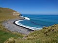
- Tumbledown Bay/Te Kāio: Considered one of the best beaches near Christchurch, often quiet. It was named after a funny incident where a man accidentally dropped bottles of alcohol down a hillside.
- Te Oka Bay: A scenic bay next to Tumbledown Bay.
- Magnet Bay: Another popular surfing spot. It's named after a ship called the Magnet that was shipwrecked there in 1844.
Mountains of Banks Peninsula
Banks Peninsula has many hills and mountains. Here are some of the tallest:
- Mount Herbert / Te Ahu Pātiki: This is the highest point on Banks Peninsula, standing at 919 metres (3,014 feet) tall.
- Mt Bradley: The second tallest peak at 855 metres (2,805 feet). It was named after Reginald Robert Bradley, an early farmer and vicar.
- Mt Sinclair: At 841 metres (2,759 feet), its Māori name is Tarawera.
- Saddle Hill: Also 841 metres (2,759 feet), it looks like a saddle.
- Mt Fitzgerald: At 826 metres (2,710 feet), it overlooks Holmes Bay.
- Flag Peak: 809 metres (2,654 feet).
- Stony Bay Peak: 806 metres (2,644 feet).
- Brasenose: 785 metres (2,575 feet).
- View Hill: 762 metres (2,500 feet).
- High Bare Peak: 756 metres (2,480 feet).
- Lavericks: 755 metres (2,477 feet).
- Duvauchelle Peak: 738 metres (2,421 feet), named after the Duvauchelle brothers.
- Mt Evans: 703 metres (2,306 feet).
Walking Tracks

- Banks Track: This is a 31 km (19 mile) circular walk that starts in Akaroa. It takes you through Flea Bay, Stony Bay, and the Hinewai Reserve.
- Te Ara Pātaka (Summit Walkway): This is a three-day hike that lets you explore the high points of the peninsula. You can start at Gebbies Pass or Kaituna Valley. The track goes past Mount Bradley and up Mount Herbert. You can stay overnight in huts like Rod Donald Hut. The walk also takes you past a very old tōtara tree (2,000 years old!) before finishing near the Hilltop tavern.
Le Race Cycling Event
Every year, there's a 100 km (62 mile) road cycling race called "Le Race." It starts in Cathedral Square in Christchurch and finishes in Akaroa. The race goes over the challenging hills of Banks Peninsula, including Dyers Pass and the Summit Road. Many famous cyclists have won this race.
Historic Churches
Banks Peninsula has many old and beautiful churches in its valleys and bays. Some examples include:
- St John the Evangelist Catholic Church, Little River
- St John the Evangelist Anglican Church, Okains Bay
- St Patrick's Catholic Church, Akaroa
- St Peter's Anglican Church, Akaroa
- Trinity Presbyterian Church, Akaroa
- Wainui Presbyterian Community Church
- St Luke's Anglican Church, Little Akaloa
- Knox Presbyterian Church, Pigeon Bay
- St Paul's Anglican Church, Port Levy
- Onuku Anglican Church, Akaroa
- St Andrew's Anglican Church, Le Bons Bay
Climate
| Climate data for Banks Peninsula (Le Bons Bay), elevation 238 m (781 ft), (1991–2020) | |||||||||||||
|---|---|---|---|---|---|---|---|---|---|---|---|---|---|
| Month | Jan | Feb | Mar | Apr | May | Jun | Jul | Aug | Sep | Oct | Nov | Dec | Year |
| Mean daily maximum °C (°F) | 19.1 (66.4) |
18.9 (66.0) |
17.4 (63.3) |
15.2 (59.4) |
13.2 (55.8) |
10.9 (51.6) |
10.0 (50.0) |
10.5 (50.9) |
12.4 (54.3) |
14.0 (57.2) |
15.4 (59.7) |
17.5 (63.5) |
14.5 (58.2) |
| Daily mean °C (°F) | 15.4 (59.7) |
15.4 (59.7) |
14.1 (57.4) |
12.2 (54.0) |
10.4 (50.7) |
8.4 (47.1) |
7.6 (45.7) |
7.9 (46.2) |
9.3 (48.7) |
10.5 (50.9) |
11.9 (53.4) |
13.9 (57.0) |
11.4 (52.5) |
| Mean daily minimum °C (°F) | 11.7 (53.1) |
11.9 (53.4) |
10.9 (51.6) |
9.2 (48.6) |
7.6 (45.7) |
5.8 (42.4) |
5.1 (41.2) |
5.3 (41.5) |
6.1 (43.0) |
6.9 (44.4) |
8.0 (46.4) |
10.3 (50.5) |
8.2 (46.8) |
| Average rainfall mm (inches) | 36.6 (1.44) |
35.7 (1.41) |
40.6 (1.60) |
49.7 (1.96) |
70.0 (2.76) |
70.1 (2.76) |
67.2 (2.65) |
70.1 (2.76) |
46.3 (1.82) |
54.9 (2.16) |
50.3 (1.98) |
47.7 (1.88) |
639.2 (25.18) |
| Source: NIWA | |||||||||||||
Images for kids
-
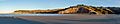
Sumner Bay from Rapanui to Scarborough
-
Taylors Mistake (2021)
-
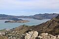
Lyttelton Harbour / Whakaraupō and Ōtamahua / Quail Island (2016)
-
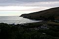
Port Levy (December 2020)
-
Pigeon Bay (December 2020)
-
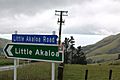
The turnoff to Little Akaloa (December 2020)
-
A light aircraft lands on the beach at Okains Bay
-
Le Bons Bay (November 2018)
-
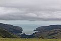
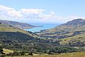
Akaroa Harbour (December 2020)
-
Tumbledown Bay
-
Te Oka Bay (left) and Tumbledown Bay (right)
-
Surf at Magnet Bay
-
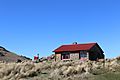
Sign of the Packhorse Hut (2020)
-
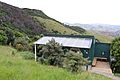
Rod Donald Hut (December 2020)


See also
 In Spanish: Península de Banks para niños
