Pegasus Bay facts for kids
Pegasus Bay is a large bay located on the east coast of New Zealand's South Island. It lies just north of Banks Peninsula. This bay was once known as Cook's Mistake because of an error on an old map made by Captain James Cook.
Contents
How Pegasus Bay Got Its Name
Pegasus Bay is named after a ship called the Pegasus. This ship was a type of sailing vessel known as a brig. In 1809, the Pegasus was sailing from Australia to London. On its journey, it was also exploring and mapping parts of the South Island.
Cook's Map Mistake
Captain Cook had drawn a map that showed Banks Peninsula as a separate island. He called it "Banks Island." The crew of the Pegasus tried to sail into a bay shown on Cook's map. They soon realized that what Cook thought was an island was actually connected to the mainland by a low strip of land. This meant it was a peninsula, not an island! Luckily, they discovered this mistake before trying to sail through the supposed gap. Because of this important correction, the bay was sometimes called "Cook's Mistake."
Maori Names for the Area
The Māori people did not divide this coastline in the same way. So, there isn't one Māori name for the entire Pegasus Bay. However, specific parts have Māori names. For example, the sandy beach between the Ashley River and the Avon/Heathcote Estuary is called Kairaki. This is an old name with a meaning that is not fully known today. Also, a fishing area to the east of the bay is known as Komaka a Te KaiKai a Waro. This means "the food store belonging to KaiKai a Waro."
Where is Pegasus Bay?
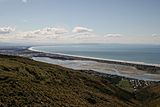
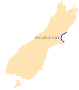
Pegasus Bay is found on the eastern side of the South Island of New Zealand. It stretches between the Motunau River and Motunau Island in the north, and Banks Peninsula in the south.
Bay Size and Depth
The bay is quite large, measuring about 75 kilometers (47 miles) across. It is also about 28 kilometers (17 miles) deep. The water in the bay is generally about 37 meters (121 feet) deep. Closer to the shore, about 2 kilometers (1.2 miles) out, the water becomes shallower, around 11 to 13 meters (36 to 43 feet) deep.
Coastline Features
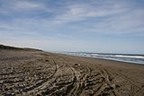
The northern part of the coastline has many cliffs. At low tide, you can find stony or sandy beaches there. A long sandy beach runs for about 50 kilometers (31 miles) along the bay. This beach stretches from the mouth of the Waipara River all the way to the Christchurch suburbs of Sumner and Scarborough on Banks Peninsula.
Rivers Flowing into the Bay
Several rivers flow into Pegasus Bay. From north to south, these include:
- Motunau River
- Waipara River
- Ashley River / Rakahuri
- Waimakariri River
- Avon River and Heathcote River (these two rivers meet and flow into the bay through the Avon Heathcote Estuary)
Animals in Pegasus Bay

Pegasus Bay is home to many interesting marine animals. You can often see dolphins swimming in the waters. This includes the Hector's dolphin, which is a special type of dolphin found only in New Zealand. Sadly, Hector's dolphins are endangered, meaning their numbers are very low.
Whales Visiting the Bay
Large whales also visit Pegasus Bay. Southern right whales and Humpback whales are known to travel through the bay during their migrations. These amazing creatures travel long distances between their feeding and breeding grounds.
The Ship Pegasus
The Pegasus was a sailing ship that played an important role in mapping the New Zealand coast in 1809.
History of the Ship
The Pegasus was originally a Spanish ship named Pegaso. It was captured by a British ship in Peru in 1807. After being taken to Australia, it was sold and renamed Pegasus. In 1808, the Pegasus began working in the sealing trade. This meant it hunted seals in the southern parts of New Zealand.
Mapping the Coastline
In 1809, the Pegasus went on another journey. This time, it was commanded by Captain Samuel Chase. William W. Stewart was the first officer on board. Stewart created maps of the New Zealand coast, including Stewart Island, which was later named after him. It was William Stewart who gave Pegasus Bay its name. Captain Samuel Chase is credited with correcting Captain Cook's map. He proved that "Banks Island" was actually a peninsula connected to the mainland. Even as late as 1843, some maps still referred to the bay as "Cook's Mistake."
 | Toni Morrison |
 | Barack Obama |
 | Martin Luther King Jr. |
 | Ralph Bunche |


