
Scarborough, New Zealand facts for kids
Quick facts for kids
Scarborough
|
|
|---|---|
|
Suburb
|
|

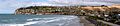
Scarborough seen from Sumner beach; Nicholson Park is the area to the left just below the ridgeline
|
|

Scarborough
Location in New Zealand
|
|
| Country | New Zealand |
| Local authority | Christchurch |
| Electoral ward | Heathcote |
| Area | |
| • Land | 117 ha (289 acre) |
| Population
(2018 Census)
|
|
| • Total | 747 |
| (Pegasus Bay) | ||
| Sumner, New Zealand |
|
|
| Port Hills | Te Onepoto / Taylors Mistake |
Scarborough is a beautiful hillside neighborhood located above Sumner in Christchurch, New Zealand. It sits between Sumner and Te Onepoto / Taylors Mistake. This area was named after a seaside town called Scarborough in England.
Contents
A Look at Scarborough's Past
The first European owner of most of the land in Scarborough was Major Alfred Hornbrook. His large farm, called Mount Pleasant, reached all the way to Godley Head. A smaller piece of land, about 25 acres (10 hectares), near what is now Nicholson Park, belonged to Charles Church Haslewood. Sadly, he died in 1858 in a hunting accident.
Later, a person named R. M. Morten bought the land. After he passed away, his sons divided Scarborough into 65 smaller plots by July 1911. The very first house in the area was built by Donald Patterson, who was a civil engineer. Patterson bought all the land between Scarborough Road and Flowers Track. He then re-divided it into 41 sections, which was twice as many as the Morten brothers had planned.
Exploring Nicholson Park
Nicholson Park is a wonderful spot covering about 4 hectares (10 acres). It offers amazing views of Sumner and the coastline of Canterbury. From here, you can walk down Flowers Track. This track used to be the main starting point for a walking path along the cliff tops. It connected Sumner and Taylors Mistake.
The old path went past places like Whitewash Head and Sumner Head. Whitewash Head got its name because of the white look from shag bird droppings. Unfortunately, much of this walking path was destroyed by two earthquakes on June 13, 2011. The earthquakes caused large parts of the cliffs to fall into the sea below.
Understanding the Red Zone
After the earthquakes, some land near the cliffs in Scarborough was marked as a "red zone." This means the land is unstable and not safe for building. The Canterbury Earthquake Recovery Authority bought these properties. The houses on this land are being taken down. Because the land is so shaky, special drones are used to study the area. This helps experts figure out the safest way to remove the buildings.
Who Lives in Scarborough?
Scarborough is part of the larger Sumner area. In 2018, about 747 people lived in Scarborough. This was a small increase from 2013. There were 285 homes in the area.
Most people living in Scarborough are of European/Pākehā background. There are also smaller groups of Māori, Pacific peoples, and Asian people. When it comes to religion, many people said they had no religion. A good number of residents are Christian, and a few follow other religions like Hindu or Buddhist.
Many adults in Scarborough have a university degree. Most people who are 15 years or older are employed, working either full-time or part-time.
Images for kids
-
Panoramic view of Scarborough from Sumner Beach
