
Sumner, New Zealand facts for kids
Quick facts for kids
Sumner
|
|
|---|---|
|
Suburb
|
|

Looking down on Sumner (left) from Scarborough
|
|

Sumner
Location in New Zealand
|
|
| Country | New Zealand |
| Local authority | Christchurch |
| Electoral ward | Heathcote |
| Area | |
| • Land | 264 ha (652 acre) |
| Population
(June 2022)
|
|
| • Total | 3,570 |
| Clifton | (Pegasus Bay) | |
| Richmond Hill |
|
Scarborough |
| Port Hills | Te Onepoto / Taylors Mistake |
Sumner is a cool seaside suburb located in Christchurch, New Zealand. It was named in 1849 after John Bird Sumner, who was an important church leader at the time. Sumner used to be its own small town, but as transport got better, it joined up with Christchurch.
Contents
A Look Back in Time
.jpg)
Sumner was first mapped out in 1849 by Edward Jollie for Captain Joseph Thomas. Captain Thomas was working for the Canterbury Association, a group that helped settle the area. The first plans for Sumner were very big, but they didn't have enough money. So, a new, smaller plan was made in 1860, which is what Sumner looks like today.
Captain Thomas chose the name Sumner to honor Bishop John Bird Sumner, a key member of the Canterbury Association. The Māori name for this area is Ohikaparuparu. This name means "place of rubbing, kindling, or planting" and "dirt, deeply laden, or a preparation of fermented cockles."
Sumner started as a small settlement in late 1849 or early 1850. The first European to work here was Charles Crawford, who helped build Captain Thomas's headquarters. The Day family was the first to live here permanently, followed by Edward Dobson and his family. Sumner got its first shop in 1870.
In 1885, a special swimming bath was built at the east end of Sumner beach. It was a popular spot, but big storms kept filling it with sand. Eventually, a flood filled it with mud, and it had to close. Sumner got its own gasworks in 1912 and electricity in 1918.
Sumner was hit by two big earthquakes in 2011, one on February 22 and another on June 13. These earthquakes caused a lot of damage. Many houses and shops were destroyed or became unsafe. The earthquakes also caused parts of Sumner's famous cliffs to collapse. Because of this, many areas had to be closed off for safety.
Exploring Sumner's Geography

Sumner is tucked away in a valley right by the coast. It's separated from other parts of Christchurch by rugged volcanic hills. These hills end in cliffs that drop down to the sea. Sumner Bay is the first bay you see on the northern side of Banks Peninsula. It faces Pegasus Bay and the huge Pacific Ocean.
Because it's open to the ocean, Sumner beach often has great waves for surfing. The beach has gentle slopes and fine grey sand, making it a very popular spot for surfers.
Behind the beach, sand dunes have filled the river valley. This made it easier to build houses. However, sometimes the valley would flood because of the sand dunes blocking the water. Now, there's a special drain to help with this problem.
A large rocky outcrop called Cave Rock stands out on the beach. For a while, it was known as Cass Rock. There are other rocky areas nearby, and you can clearly see that the land here was formed by volcanoes. A sea wall and a wide walkway have been built along the beach to protect it from the ocean.
The Sumner Bar

At the western end of the beach, near another large rock called Shag Rock (or Rapanui), is the Sumner Bar. This is where the Avon Heathcote Estuary meets the sea. The Sumner Bar is a sand bar, and it can be very dangerous for boats. The currents here are strong, and there can be powerful rips and undertows, which are also risky for swimmers.
One famous event happened in 1865 when a ship called the Mullogh got stuck on Cave Rock during a storm. Its cargo of drinks caused a lot of excitement on the beach! Another boat, the NZ Trawler Muriel, was stranded on Sumner Beach in 1937 and had to be taken apart.
Sumner Lifeboat Institution
Because the Sumner Bar can be so dangerous, Sumner has had a lifeboat for a very long time. The Sumner Life Boat Institution has been officially operating a lifeboat or rescue boat since 1898. Many of their lifeboats have been given the traditional name Rescue.
People and Population
Sumner, which includes nearby Scarborough and Te Onepoto / Taylors Mistake, covers about 2.64 square kilometers. In 2018, about 3,519 people lived here.
Most people in Sumner are of European background (95.6%). About 4.9% are Māori, and smaller numbers are from Pacific Islands or Asia. Many people in Sumner (29.5%) were born overseas.
When asked about religion, most people (57.6%) said they had no religion. About 33.5% were Christian.
Many adults in Sumner have a university degree (39.7%). The average income in Sumner was $43,600 in 2018. More than half of the people aged 15 and over work full-time.
Learning in Sumner
Sumner has several schools for children and young people.
Sumner School
Sumner School opened in 1876. It's a primary school for children from Year 1 to Year 8 (ages 5 to 13). It has about 342 students.
Our Lady Star of the Sea School
This is a Catholic primary school for children from Year 1 to Year 8. It opened in 1928 and has about 80 students.
Ko Taku Reo
This school helps children who are hearing-impaired. It used to be called van Asch College and opened in 1880 as Sumner School for the Deaf. Now, it's a special campus for Ko Taku Reo.
Sumner College
Sumner College was a boarding school for boys that existed from about 1877 to 1895. It was also known as "Beach Glen Boarding School." The school taught subjects like English, Latin, and French. Boys could also enjoy sea swimming, cricket, and walking trips. The school's buildings were later used by the Government School for the Deaf.
The headmaster, C. L. Wiggins, was born in England in 1843. He was a church organist, Sunday school teacher, and helped start the Sumner Lawn Tennis Club. He was also involved in local government.
Getting Around Sumner
It was always important to find good ways to travel between the port at Lyttelton and Christchurch. Sumner was also planned to be a settled area early on.
By Sea
The Sumner Bar is a tricky spot for boats, but it can be crossed safely when the weather and tides are right. Sailors need to be very skilled to cross it.
There's a small boat harbor at the south-eastern end of Sumner Bay, near Scarborough. It has a strong wall to protect it. There's also a ramp for launching small boats and the lifeboat station. However, this area can sometimes fill up with sand.
In 1849, this spot was called Sumner Nook. It was the only safe place in the bay to land from a boat. But there was no safe place for bigger ships to anchor nearby, except for Lyttelton Harbour, which was about 8 nautical miles away.
By Land
Building a road from Lyttelton to Christchurch through Sumner was important from the very beginning. Even though there are now train and road tunnels, the route through Sumner is still needed for very large or dangerous goods that can't go through the tunnels.
Work on a road from Lyttelton to Christchurch through Evans Pass and Sumner started in 1849. It was slow because of steep hills and hard volcanic rock. In 1850, a walking path called the Bridle Path was made over the hills. This allowed early settlers to walk to Ferrymead, but heavy goods still had to go by boat across the Sumner Bar. The original road project stopped in 1851 because of difficult cliffs and a lack of money. This old road line is now known as Captain Thomas' Track. A new, easier route was later found and built on the eastern side of the valley.
Public Transport
A tramway, which is like an old-fashioned streetcar, started running to Sumner on November 1, 1888.
Famous People from Sumner
Many interesting people have lived in or been connected to Sumner:
- Rita Angus (1908–1970), a famous painter.
- Edward Dobson (1816/17? – 1908), an early landowner in the area.
- Ruth France (1913–1968), a librarian, poet, and writer.
- Denis Glover (1912–1980), a poet and publisher.
- William M. Hodgkins (1833–1898), a painter.
- William Orange (1889–1966), a church leader.
- Samuel Hurst Seager (1855–1933), an architect who designed houses in the area.
- Petrus Van der Velden (1837–1913), a Dutch-born painter.
- Felix Wakefield (1807–1875), one of the first landowners.
Images for kids
-
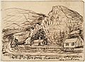
Dobson's house, on left (pencil sketch, 1865)
-
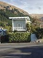
Pascoe House (2012)
-
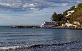
Sumner Lifeboat Station, Scarborough Slipway and Boat Harbour


