Rapanui Rock facts for kids
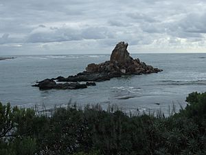
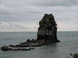
Shag Rock, also known as Rapanui, is a famous rock formation in New Zealand. It stands near the entrance of the Avon Heathcote Estuary in Christchurch. This rock has been an important landmark for sailors and people traveling to Sumner. It sits close to the southern shore, visible even at low tide. In the 2011 Christchurch earthquake, the rock broke into pieces. Locals sometimes jokingly call the remains "Shag Pile" because it looks like a pile of rubble.
Even though large ships no longer use the estuary, smaller boats can still go quite far inland. They can reach places like Ferrymead if the water conditions are good. The main path for boats into the estuary is on the northern side of Shag Rock.
Contents
What's in a Name?
The Māori name for the rock is Rapanui. It means "the great sternpost," like the back part of a canoe. This name comes from an old Māori legend. It's one of the oldest landmarks in the area. Some people also think Rapanui could mean "scattered stones deeply embedded in the ground." This name fits well, especially after the earthquake.
The name Shag Rock first appeared on maps in 1854. Before that, it was just an unnamed rock. After the 2011 earthquakes, the rock became much shorter. Some people started calling it "Shag Pile" as a joke. Others, with a bit more humor, called it "Shagged Rock."
How Did Shag Rock Form?
Shag Rock is a type of rock formation called a sea stack. A sea stack is a tall, thin piece of rock that stands in the sea. It gets separated from the main cliff over time. This happens because of natural processes like waves and wind. The changes you saw in Shag Rock during the 2010-2011 earthquakes are part of this natural process. The cliffs nearby also collapsed, showing how the rock might have become separate. There are also many rocks on the land side of Shag Rock. This suggests it was much bigger a long time ago.
Before the 2011 Earthquake
Before the big earthquake, Shag Rock was about 11 meters (36 feet) tall. Its exact height depended on how high the tide was.
After the 2011 Earthquake
The rock crumbled during the 6.3 magnitude earthquake on 22 February 2011. This event significantly reduced its height.
Shag Rock has always been a clear landmark. Sailors used it to figure out where they were at sea. It also helped travelers on the road to Sumner. The rock shows where the Avon Heathcote Estuary meets the sea. It's close to the shore and you can even walk to it at low tide. Because it's so tall and stands out, it was a great natural marker. Sailors could use it to know their ship's position, especially near the shallow waters of the Sumner Bar.
In the 1800s, the shipping path was different. Ships had to sail very close to another rock called Cave Rock. Then they would turn and sail across the beach to get around Shag Rock. Today, the channel between the estuary and the sea goes more directly out to the ocean. It's now on the northern side of Shag Rock.
Even though big ships don't use the estuary anymore, smaller boats can still go far inland. They could even sail up the Avon River to the city center. They could also go up the Heathcote River. This allowed many goods to be moved by water in the past.
Shag Rock in Art and Culture
Shag Rock has been a popular subject for artists since the 1800s. Many people have captured its beauty in different ways.
Photography of Shag Rock
People have been taking photos of Shag Rock since at least 1861.
- One old photo from 1861 shows Shag Rock as an island. It also shows the road to Sumner before the tramway was built. This photo is now kept at the Auckland Art Gallery.
- Another photo from the early 1900s shows a view of Shag Rock at Sumner. This picture is part of a collection of old postcard negatives.
Poetry and Visual Arts
Shag Rock has even inspired poems, like an "Ode to Shag Rock." Many painters have also featured it in their works:
- Charles Decimus Barraud (1822-1897) painted Shag Rock several times. One painting from 1869 shows the rock and the road under the cliffs. This painting is now at the Christchurch Art Gallery.
- William Mathew Hodgkins (1833-1898) also painted Shag Rock. One of his paintings shows the rock with a sailing ship nearby. Another painting shows Shag Rock in the background, seen through a cave opening.
 | James B. Knighten |
 | Azellia White |
 | Willa Brown |


