Avon Heathcote Estuary facts for kids
Quick facts for kids Estuary of the Heathcote and Avon Rivers / Ihutai |
|
|---|---|

Christchurch with its estuary
|
|
| Coordinates | 43°32′49″S 172°43′23″E / 43.547°S 172.723°E |
| River sources | Avon River Heathcote River |
| Ocean/sea sources | Pacific Ocean |
| Basin countries | New Zealand |
| Surface area | 8 km2 (3.1 sq mi) |
| Settlements | Christchurch |
The Estuary of the Heathcote and Avon Rivers / Ihutai is a special watery place in Canterbury, New Zealand. It's the biggest "semi-enclosed shallow estuary" there. This means it's a bay that's partly closed off from the sea, and it's not very deep.
This estuary is super important! It's one of New Zealand's most valuable coastal wetlands. Wetlands are like nature's sponges, full of amazing plants and animals. The estuary is famous around the world as a home for migratory birds. These birds travel huge distances and stop here to rest and find food.
It's also a great spot for fun activities and learning. Long ago, Māori people called it mahinga kai. This is a Māori term that means a place where you gather food.
Contents
Where is the Estuary?
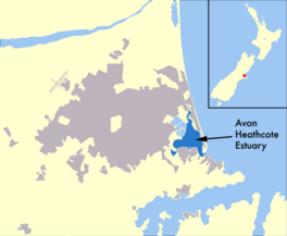
The Estuary of the Heathcote and Avon Rivers / Ihutai is located near the city of Christchurch. Two rivers flow into it: the Avon River from the northwest and the Heathcote River from the southwest.
The estuary has a shape like a triangle. It connects to Pegasus Bay through a short opening. A long strip of land called Brighton Spit helps to enclose it. This spit is about 4 kilometers (2.5 miles) long. The suburbs of New Brighton, South New Brighton, and Southshore are built on this spit.
Near the entrance to the estuary, there's a deep channel. This channel runs between a rock called Rapanui Rock (also known as "Shag Rock") and Brighton Spit.
What is the Estuary Like?
The estuary covers an area of about 8 square kilometers (3 square miles). It's quite shallow, which is typical for an estuary.
At high tide, the average depth is about 1.4 meters (4.6 feet). Most of the estuary is "intertidal." This means that about 85% of its area is covered by water at high tide but becomes exposed land at low tide. Only about 15% of the estuary stays underwater all the time.
How Did it Get its Name?
The official name of this special place is "Estuary of the Heathcote and Avon Rivers / Ihutai." This name was made official in 1998.
It happened because of an important law called the Ngāi Tahu Claims Settlement Act 1998. This law recognized the historical rights and connection of the Ngāi Tahu Māori people to their land and waterways. Adding "Ihutai" to the name honors the Māori heritage and their long relationship with the estuary.
Protecting the Estuary
To help look after the estuary for the future, the Avon–Heathcote Estuary Ihutai Trust was created in 2002. Many people in the community wanted to make sure this important place was protected for a long time.
The Trust brings together different groups and people. This includes local community members, environmental groups like "Friends of the Estuary," and representatives from the Christchurch City Council and Environment Canterbury. It also includes tāngata whenua, who are the local Māori people, and other organizations. They all work together to protect and care for the estuary.
 | Tommie Smith |
 | Simone Manuel |
 | Shani Davis |
 | Simone Biles |
 | Alice Coachman |


