Southshore, New Zealand facts for kids
Quick facts for kids
Southshore
|
|
|---|---|
|
Suburb
|
|
Southshore and South New Brighton
|
|
| Country | New Zealand |
| Local authority | Christchurch |
| Electoral ward | Coastal |
| Area | |
| • Land | 124 ha (306 acre) |
| Population
(2018 Census)
|
|
| • Total | 1,041 |
|
|
||
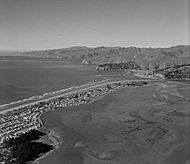
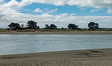
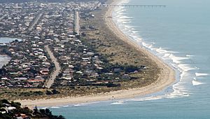
Southshore (which in Māori is Te Kōrero Karoro) is a cool coastal suburb in Christchurch, New Zealand. It sits on a narrow strip of land called a sandspit. This sandspit is about 2.5 kilometers long. It runs along the eastern side of the Avon Heathcote Estuary. Southshore is about 8 kilometers east of the city center. It is also 5 kilometers south of New Brighton's main shops.
Long ago, this area was mostly swampland. It had big sand dunes where Māori people lived. The area is very important to local Māori iwi (tribes). This is because they gathered lots of food and seafood here before Europeans arrived. Early European settlers called the area "Sandhills Run". They built small holiday homes called baches. They also set up a dairy farm. Southshore did not have many people living there permanently at first. This was because it lacked facilities and good transport. It grew much bigger after World War II. Southshore is part of the Coastal Ward for the Christchurch City Council. It is also part of the Christchurch East area for national elections. The suburb was damaged in the 2011 Christchurch earthquake. Many properties were marked as "red-zoned," meaning they were too damaged to rebuild on. Southshore can also be affected by coastal dangers like tsunamis and sea level rise.
Contents
What's in a Name?
The Māori name for Southshore is Te Kōrero Karoro. This means "the chattering of the seagulls." It can also mean "the meeting place of the seagulls." The sandspit was sometimes called Te Ihutai. This means "the nose of the tides."
Before the 1900s, early European settlers called the area "Sandhills Run." But people don't use this name anymore. The name Southshore became official in 1955. The Canterbury Museum suggested using Te Kōrero Karoro. However, many locals did not like this idea. They thought the name was "too long." Also, Māori names were not very popular back then. The Christchurch City Council suggested "Southend." But residents preferred "Southshore." They had known the area by this name for over ten years. "Southshore" was also the name of an early housing area there.
A Look Back in Time
Early Māori Life
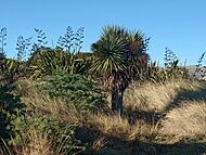
The Māori were the first people to live on the sandspit. They called it Te Kōrero Karoro. Southshore was a very important place for Māori to gather food. The area had (and still has) many different birds and plants. There were many Māori houses (whare) around the estuary. These were mostly built from local raupō plants and other native trees. Southshore is important to Māori culture and history. This is because they gathered lots of pipi (shellfish) and flounder (fish) here.
In the 1700s, Māori mainly grew aruhe (fern root) and kūmara (sweet potato). They grew these in the sandy soil around the area. This was especially true near the mouth of the Avon River. Early European settlers found Māori fishing tools and eel traps. They also found hāngī pits. These were used by Māori to cook seafood. It was once believed that a jogger found a wharenui (meeting house) totem in the sand dunes near Tern Street. But some people doubt this story. There are no official records of it. Later, a human skull was found. It was dated back to the time when Māori lived there.
The suburb is culturally important for Ngāi Tūāhuriri. They are the kaitiaki (caretakers) of the area. They have special rights to gather food in the estuary and nearby. There was a walking path from the fortified village of Kaiapoi Pā. It went towards South New Brighton. Then it continued to what is now Southshore. It even went across the Avon Heathcote Estuary to the Banks Peninsula. There was also a sand dune path called Pohoareare. This path connected the Ōpāwaho settlement to New Brighton and then to Te Kōrero Karoro.
European Settlers Arrive
Before the 1900s, European settlers called the area "Sandhills Run." As more settlers came, they built small holiday homes called baches. They also started a dairy farm in the suburb. In 1916, most of the area was divided into sections for houses. In the early 1900s, there was not much transport. There were also few facilities. So, Southshore had very few people living there all the time.
"The Spit" was used as a gun range for volunteers. They practiced there during and after World War I. The suburb grew slowly because it lacked basic services. It didn't get a water supply until 1954. In 1953, Southshore residents finally got electricity. Southshore grew quickly and became much more developed after World War II. It got a sewerage system in 1967. The main road, Rocking Horse Road, often flooded. So, channels and kerbs were added to fix this.
There is a large public park at the southern end of the suburb. This is where most of the fun outdoor activities happen. Southshore does not have its own primary or secondary schools. The closest primary school is South New Brighton School. It was built in 1922 and is about 3.2 kilometers north.
Where is Southshore?
The Avon-Heathcote Estuary was formed about 1000 to 2000 years ago. This happened because sand from the Waimakariri River mouth was carried south. It built up along the east coast of the South Island. This slowly formed what is now called the "Southshore Spit." The Spit is a 2.5-kilometer-long sandspit. It is about 300 meters wide where it meets South New Brighton. It gets wider at its southern end, reaching about 500 meters.
The suburb is on a narrow sandspit. It is located between the Pacific Ocean and the Avon Heathcote Estuary. To the north of Southshore is South New Brighton. To the south, across the estuary, are Sumner and Rapanui Rock. This rock is also known as "Shag Rock." The "Sumner Bar" is a natural barrier between the suburbs. Southshore is mostly a place where people live. Before Europeans settled, the area from Heron Street to Torea Street was mostly swampland. It was surrounded by large coastal sand dunes. In Christchurch's early days, the "Brighton Spit" meant all the land south of Bridge Street. Today, Southshore's border with South New Brighton is Caspian Street.
From the western side of the "Southshore Spit," you can see the estuary. You can also see some of Christchurch's other eastern suburbs. Parts of the Hillsborough spur are also visible. Other nearby suburbs include Redcliffs, Mount Pleasant, and Ferrymead. Southshore is about 8 kilometers from the city center. It is also about 5 kilometers from New Brighton's main shopping area.
Because it's on the coast, Southshore faces challenges. These include sea-level rise, flooding, and coastal erosion. As of 2024, the Christchurch City Council has approved 12.5 million New Zealand dollars. This money is for fixing erosion and flooding problems in Southshore and South New Brighton. The council said no to fixing collapsed walls along the estuary edge. Instead, they suggested building a cobble (round stone) beach along the eastern edge of the estuary. This plan faces challenges because of local archaeological sites and coastal bird populations. Southshore is also at risk from other sea-related dangers like tsunamis and storms.
How Southshore is Governed
Southshore is part of the Coastal Ward. This is for local elections in Christchurch. The current elected councilor is Celeste Donovan. For national elections, Southshore is part of the Christchurch East area. The current Member of Parliament is Reuben Davidson from the Labour Party. Historically, Christchurch East has usually voted for the Labour Party. It is seen as one of Labour's safest areas. The Christchurch City Council manages Southshore.
Who Lives in Southshore?
Southshore is part of the South New Brighton statistical area.
| Historical population | ||
|---|---|---|
| Year | Pop. | ±% p.a. |
| 2006 | 1,395 | — |
| 2013 | 1,137 | −2.88% |
| 2018 | 1,041 | −1.75% |
In 2018, Southshore had a population of 1,041 people. This was a decrease of 96 people since 2013. It was also a decrease of 354 people since 2006. There were 417 households. There were 519 males and 525 females. About 19% of the people were under 15 years old. About 17.6% were 65 or older.
Most people (94.2%) were European/Pākehā. About 12.1% were Māori. People can identify with more than one ethnic group.
Many people (59.7%) said they had no religion. About 28.8% were Christian.
Earthquakes in Canterbury
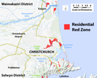
Southshore was badly affected by the earthquakes. These were the 4 September 2010 Canterbury and 22 February 2011 Christchurch earthquakes. Houses and land were damaged. Southshore was first put into an "orange zone." This meant decisions were still being made. Later, on 29 October 2011, the beach side was zoned "green." This meant it was safe to rebuild. But the estuary side stayed in the orange zone. A decision was needed on whether it was worth fixing and rebuilding there. This was because of the huge damage from the main quakes and ongoing aftershocks.
In August 2011, residents were told a decision would come in six weeks. But it was delayed several times. On 12 October, Gerry Brownlee, the Earthquake Recovery Minister, apologized for the delays. He asked for more patience. The decision on 29 October 2011 split Southshore into two zones. In November, another suburb, Brooklands, was zoned "red." This meant people could not rebuild there. But the decision for Southshore was delayed again. On 23 March 2012, decisions were made for other areas. But Brownlee wrote to the 401 Southshore homeowners. He said they should have a decision in April.
By the end of April, Roger Sutton, head of the Canterbury Earthquake Recovery Authority, apologized for more delays. The final decision came on 18 May 2012. Out of 401 properties, 198 were zoned red. The other 203 properties were allowed to be lived in. As of 2024, the red-zoned western side of the suburb, facing the estuary, is now an urban green space.
Getting Around Southshore
Historically, Southshore was an important travel path for the Māori. They used the suburb as a way to travel south along the coastal sand dunes. In 1912, there was a plan to build a bridge from Southshore to Sumner. But several local groups were against it. A local farmer named "Moore," who grazed animals on the spit, also opposed it. So, the bridge was never built. In 2014, another idea came up. This was to install a "chain ferry link" across the estuary. But this idea was also never completed.
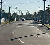
Since 1939, the main and only way into the suburb has been Rocking Horse Road. The name reportedly comes from Peter Skellerup. He was a former deputy-mayor of the city. He drove on the road when it was new. He told his son it felt like "traveling on a rocking horse." This was before it was paved and smoothed out.
In 1952, the suburb was connected by several bus routes. These went to nearby suburbs and central Christchurch. In 1981, residents saw the opening of the South Brighton Bridge. This saved people time and made travel easier. Today, Southshore's public transport uses the Metro bus service. The frequent Hillmorton—Southshore (route 60) bus serves the suburb. It connects to nearby suburbs. Its final stop is the suburb of Wigram, on the other side of the city.
Famous People from Southshore
Many notable people have connections to Southshore. Some of them were "original residents" and lived there for a long time.
- Angus Tait: An inventor and businessman who started Tait Communications.
- Ivan Mauger: A famous motorcycle speedway rider, considered one of the world's "Greatest Riders."
- Peter Skellerup: An industrialist and generous person. He was also the former deputy-mayor of Christchurch from 1974 to 1980.
- Richard Petrie: An international cricketer who played 12 One Day Internationals.
- Tipene O'Regan: A scholar and chairman of the Ngāi Tahu Māori Trust. He moved out of the suburb when his property was red-zoned after the earthquakes.
 | Bessie Coleman |
 | Spann Watson |
 | Jill E. Brown |
 | Sherman W. White |


