
Port Hills facts for kids

The Port Hills (also known as Māori: Ngā Kohatu Whakarakaraka o Tamatea Pōkai Whenua in Māori) are a range of hills in the Canterbury Region of New Zealand. They get their name because they are located between the city of Christchurch and its port at Lyttelton. These hills are what's left of the Lyttelton volcano, which erupted millions of years ago.
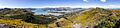
The hills start at Godley Head and stretch mostly from east to west along the northern side of Lyttelton Harbour. They then turn south, separating the city from the harbour. The range ends near Gebbies Pass, which is at the head of the harbour. Many of the peaks in the Port Hills are between 300 and 500 metres above sea level. These hills are very important for their geology, nature, and beautiful views.
Contents
History of the Port Hills

The volcano that formed the Port Hills is one of two volcanoes that created Banks Peninsula about 12 million years ago. The first people to live in this area were the Māori, who arrived in the 14th century.
When European settlers arrived about 500 years later, the Port Hills were a big challenge. They stood between the harbour and the new settlement of Christchurch. The hills were very steep and rugged, making it hard to get across them. For many years, most settlers used a very steep path called the Bridle Path to carry themselves and their belongings to the plains on the other side.
Today, things are much easier! A road tunnel called the Lyttelton road tunnel and a separate rail tunnel connect the port and the city. There are also three main roads that cross the hills: via Evans, Dyers, and Gebbies passes. These roads are all connected by the Summit Road, which offers amazing views.
In February 2017, large bush fires swept through the Port Hills. They burned for several days, destroying over 2000 hectares of bush and some homes.
Geography and Nature of the Port Hills

The Port Hills are a very noticeable part of the central Canterbury landscape. You can see them from many kilometres away to the north and west.
The height of the Port Hills changes along their crest, being lowest at the eastern (seaward) end. Two main road passes cross the Port Hills from Christchurch. Dyers Pass, which is about 330 metres high, is almost directly south of central Christchurch and is the more well-known pass. Evans Pass, about 200 metres high, is near the eastern end of the hills. It usually connects Sumner and Lyttelton. This pass was closed for a while after the 2011 Christchurch earthquake damaged Sumner Road, but it reopened in 2019.
Between Evans Pass and Dyers Pass, there are several important peaks. These include Sugarloaf (494 m), which is easy to spot because of the television tower on its top. There's also Mount Cavendish (448 m) and Tauhinukorokio / Mount Pleasant (499 m), which is the highest peak in the northern part of the Port Hills. West of Dyers Pass, the Port Hills curve southward and become even higher, reaching 573 m at Coopers Knob. From Coopers Knob, the hills slope down to Gebbies Pass (about 160 m high). The hills south and east of Gebbies Pass are considered part of Banks Peninsula itself, not the Port Hills.
Some suburbs of Christchurch are built on the northern slopes of the Port Hills. These include Cashmere, Mt Pleasant, Heathcote Valley, and Sumner. Other parts of the hills are used for farming and growing trees. Many areas are also protected as scenic reserves for people to enjoy and to help nature. This idea started with Christchurch councillor Harry Ell around the year 1900. In 1948, the Summit Road Scenic Society was formed to keep developing and looking after these reserves.
The Port Hills are a popular place for Christchurch residents to have fun outdoors. There are many public parks and reserves with tracks for mountain biking and walking. A gondola lift to the top of Mount Cavendish opened in 1992. It makes it easy to get to the summit and is a big attraction for visitors. The Christchurch Adventure Park opened in 2016, offering more mountain biking trails on the slopes of Worsleys Hill. Road cycling is also very popular on the Port Hills, with routes like "short bays" and "long bays" being favourites.
Wildlife and Plants
Even though a lot of the native bush was cut down when settlers first arrived, many different animals and plants still live in the Port Hills. Native birds like the bellbird (korimako or koparara), fantail, silvereye, grey warbler, and shining cuckoo are often seen in the remaining bush areas. The wood pigeon is also native to New Zealand and common here. However, other birds like the common blackbird, common chaffinch, and song thrush were brought here from other countries and are now very common. Besides many types of insects, you can also often find geckos and skinks.
Native plants like Banks Peninsula hebe grow in rock cracks, along with rare ferns. The more open hillsides are covered with silver tussock and other native grasses. This is quite unusual for an area so close to a city.
The remaining native forest, called podocarp forest, has very old trees. Some mataī, tōtara, and kahikatea trees are 500 to 600 years old! You can also find fruit and flowering plants like kōwhai, ribbonwood, māhoe, cabbage trees, kānuka, and fuchsia.
Images for kids
-
Panoramic view of Port Hills from Mt Ada
