Bridle Path (New Zealand) facts for kids

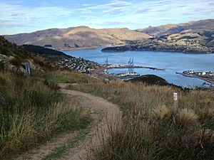
The Bridle Path is a popular track in the South Island of New Zealand. It goes over the hills between the port town of Lyttelton and the city of Christchurch. This path is great for walking and mountain biking.
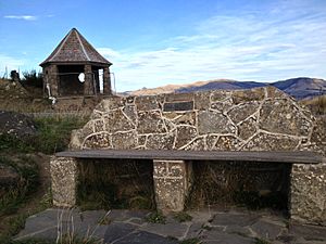
The track climbs high up from Lyttelton, reaching about 333 metres. Then, it goes down towards Christchurch through Heathcote Valley. At the very top, you'll find a stone shelter. This shelter was built in 1940 to remember the brave pioneer women of Canterbury. There are also seven special stone seats along the path, many added for the Canterbury centenary in 1950.
The Bridle Path was built very quickly in late 1850. It was ready just in time for the first settlers from the Canterbury Association. This path was the fastest way to get from the port to the new settlements on the plains. Even though it was very steep, it was the main route over the hills. This was true until the Sumner Road opened in 1858. The path is called a bridle path because it was so steep and narrow. Riders often had to get off their horses and lead them by the bridle. It was not suitable for heavy carts.
The track is still a legal road today. This means vehicles like trail bikes could use it, but most people prefer it for walking and biking.
Contents
What is the Bridle Path Like Today?
The Bridle Path is a legal road that connects Lyttelton and Ferrymead. It was first built so that early settlers could move horses, cattle, and sheep from the port to their new farms. The path was too steep to ride horses all the way. So, riders had to lead their horses, which is how it got its name.
Today, parts of the old path are now sealed roads called Bridle Path Road. You can find these roads in both Lyttelton and Heathcote Valley. The steep middle part is still a walking track.
The walking track starts at the end of Bridle Path Road in Lyttelton. It climbs to the top of the ridge and then goes along the crater rim. It crosses the Summit Road before going down to the Heathcote Valley. This walk is about 2.4 kilometres long. It takes about an hour to walk one way to the 333-metre high summit. You can use the number 28 bus to get between the two ends of the walk.
At the summit, the Bridle Path meets the Summit Road. Here you will find the Canterbury Pioneer Women's Memorial and a car park. Other tracks like the Crater Rim Walkway and Stan Helms Track also meet here. These tracks can be wet and slippery in winter. The city council suggests being careful. You can walk your dog here, but they must be on a lead.
History of the Bridle Path
In 1850, Charlotte Godley wrote about a path over the hills. Her husband, John Robert Godley, and Captain Thomas rode on it when they first visited Lyttelton. Charlotte herself walked the path and found it "very good, though steep." She enjoyed the "very fine" view of the harbour and plains.
A proper Bridle Road was surveyed in November 1850. This was done by Edward Jollie under the direction of Captain Thomas. John Robert Godley had found more money to continue road building. A team of workers then formed the path. It was planned to be about 2.4 metres wide. On the Heathcote Valley side, the path went down to the valley floor. It then ran to Ferrymead, where a ferry crossed the Heathcote River.
When Charlotte Godley used this Bridle Road in December 1850, most of it was ready. Only a small part near the top was still rough.
Before the Bridle Path, shipping heavy goods from Lyttelton to Ferrymead was risky. Ships had to sail on the open sea and then cross a sandbar. This was dangerous, and many settlers lost their belongings. Shipping costs were very high, sometimes as much as shipping goods from England!
By 1851, a refreshment stall was set up at the summit. This offered a place for travellers to rest.
For several years, people wanted a better way to connect Lyttelton and the plains. They looked at different ideas, including road and railway tunnels. A new, easier road was planned, which included a short tunnel. This new road was officially opened in 1857. It was fully open to light traffic by January 1858.
In 1862, New Zealand's first telegraph line was built along this route. It opened on 1 July 1862.
The opening of the Christchurch to Lyttelton Railway in 1869 made the Bridle Path less important for travel.
In the 1930s, the Bridle Path was improved. The Summit Road also opened in 1938, making access even easier.
The Bridle Path became a Historic Area on 6 April 2001. It remains a popular walking track today.
Memorials Along the Path
Pioneer Women in Canterbury
In 1938, a special idea came up. People wanted to build a memorial for the pioneer women of Canterbury. This memorial would be a gift for New Zealand's centenary celebrations. It was planned to be sheltered seats at the top of the Bridle Path.
The Canterbury Pioneer Women's Memorial is located at the top of the Bridle Path. The first stone for the memorial was laid on 16 December 1939. The shelter was designed by Heathcote Helmore. The memorial was officially opened on 14 December 1940, with many people attending.
Commemorative Stone Seats
There are seven special stone seats along the Bridle Path. Most of these were built for the Canterbury centenary celebrations in 1950.
Wayside Memorial Cross
A Wayside Memorial Cross was put up in 1856. Charlotte Godley asked for it to mark a small spring where she had rested. The first cross was made of white stone. It was replaced several times because it was damaged. The cross was eventually destroyed in the 2011 earthquakes.
Re-enactments
In December 1950, people celebrated the Canterbury centennial. They re-enacted the arrival of the first ships. Some descendants of the original settlers dressed in old costumes. They then walked over the Bridle Path, just like their ancestors did.


