Lyttelton Harbour facts for kids
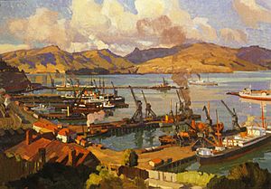
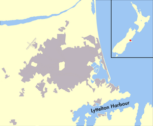
Lyttelton Harbour / Whakaraupō is a large bay on the coast of Canterbury, New Zealand. It's one of two main bays on the Banks Peninsula, with Akaroa Harbour being the other.
This harbour stretches about 15 kilometers (9 miles) from its entrance to a town called Teddington. It sits inside what used to be a huge volcano! The steep sides of this old volcano now form the Port Hills on its northern side.
The main town here is Lyttelton, which is a busy port for the city of Christchurch. Lyttelton is connected to Christchurch by a rail tunnel (opened in 1867), a road tunnel (opened in 1964), and two roads over the Port Hills. Other towns around the harbour include Diamond Harbour to the south, the Māori village of Rāpaki to the west, and Governors Bay at the very end of the harbour.
Two islands are also found here: Quail Island is near the end of the harbour, and Ripapa Island is just off the south shore near Purau Bay.
The harbour is home to a busy commercial port in Lyttelton. This port has a place to store oil and a modern terminal for shipping containers and other goods. You might even spot Hector's dolphins, a special type of dolphin found only in New Zealand, and New Zealand fur seals living in the harbour.
Contents
What's in a Name?
The official name for this bay is Lyttelton Harbour / Whakaraupō. This dual name is usually seen on maps or official papers. It became official because of a law passed in 1998 called the Ngai Tahu Claims Settlement Act.
Māori Names
In the Māori language, the harbour is called Te Whakaraupō. This means "Bay of raupō" (a type of reed). This name came from a swamp where many raupō reeds grew near Ōhinetahi, or Governors Bay. Sometimes, in older writings, you might see it spelled Whangaraupo, which also means "Bay of the Raupo reeds."
In 1849, Captain Stokes, who was surveying the harbour, preferred to call it Wakaraupo Bay. However, when the harbour officially became a port in August 1849, it was named Port Victoria instead.
European Names
Most people today use the name Lyttelton Harbour, especially in everyday talk. This name isn't official, but everyone knows it. It was used before 1998. It's not totally clear how it got this name. John Robert Godley used it in a speech in 1853. It appeared officially in 1858 when describing the area for the town of Lyttelton.
The first common European name for the harbour was Port Cooper. This name was used in the mid-1840s. It was named after a person called Daniel Cooper.
In 1849, Port Cooper was officially changed to Port Victoria. This was when it became a "Port of Entry," meaning ships could officially enter and leave New Zealand from here. It was named after Queen Victoria, who was the monarch of the United Kingdom. However, the name Port Victoria didn't become widely used right away.
The harbour's name was officially changed to Lyttelton Harbour in 1858. This was to honor George William Lyttelton, who was the chairman of the Canterbury Association.
Another older, less common name was Cook's Harbour. This name came from the early explorations by James Cook.
A Look Back in Time

Some islands in the harbour have interesting histories. King Billy Island was a place where Māori people found sandstone. They used this stone to grind other stones, like pounamu (greenstone).
Nearby Quail Island was used as a place for people with leprosy (a serious skin disease) between 1918 and 1925. Today, Quail Island is a special nature reserve.
Fort Jervois
Ripapa Island has a fort called Fort Jervois. It was built between 1885 and 1895 to protect the harbour. During World War I, Ripapa Island was used to hold German citizens who were considered "enemy aliens." One famous person held there was Count Felix von Luckner.
Ferry Services
In 1877, the Lyttelton Harbour Board (now Lyttelton Port Company) began building an inner harbour. In 1895, a company started a steamship service between Lyttelton and Wellington. This service was called the "Steamer Express" from 1933.
However, in 1962, New Zealand Railways started a new ferry service called the Interislander. This new service went between Picton and Wellington. It was a shorter trip and used diesel ships, which were cheaper to run. The Steamer Express service eventually stopped in 1976, leaving the Interislander as the main ferry link between New Zealand's two main islands.
Harbour Geography
Lyttelton Harbour was formed when an ancient volcano collapsed and the sea flooded into the crater. This volcano was one of several that created the Banks Peninsula.
The entrance to Lyttelton Harbour is about 2 kilometers (1.2 miles) wide. From the entrance, the harbour stretches about 7 nautical miles (13 kilometers) to the west-south-west. The port of Lyttelton is about 4 nautical miles (7.4 kilometers) up the harbour on the northern shore.
The harbour is about 8 fathoms (15 meters) deep at its entrance. It gets shallower towards the port, where it's about 3.5 fathoms (6.4 meters) deep. The bottom is mostly soft mud. There's one main danger for ships near the port called Parson Rock, which is a submerged rock. The shipping channel has been made deeper so that larger container ships can use the port.
The winds in Lyttelton Harbour usually come from the north-east and south-west. Strong south-west winds can be very powerful. In October 2000, a storm with winds of 130 km/h (81 mph) sank 32 boats and destroyed a marina.
Bays and Headlands
As you go around the harbour from Godley Head to Adderley Head, you'll find many interesting bays and points:
- Mechanics Bay: This is where supplies for the Godley Head lighthouse were brought ashore.
- Otokitoki / Gollans Bay: This bay is below Evans Pass.
- Polhill's Bay: This area has been completely filled in to create Cashin Quay, part of the port.
- Corsair Bay: A popular spot for swimming.
- Cass Bay: Named after Thomas Cass, one of the harbour's early surveyors.
- Governors Bay: A settlement at the head of the harbour.
- Te Wharau / Charteris Bay: Another bay with a dual name.
- Kaioruru / Church Bay:
- Te Waipapa / Diamond Harbour: A town on the south side of the harbour.
- Purau Bay:
- Waitata / Little Port Cooper: This was once a whaling station.
Islands in the Harbour
- Aua / King Billy Island: This is a small island between Quail Island and Moepuku Point. It's also been called Little Quail Island.
- Otamahua / Quail Island: This island is usually known as Quail Island. It got its name in 1842 when a captain saw native quail there. The Māori name Otamahua means "eggs of the sea fowl."
- Kamautaurua Island: This island was also known as Kamautaurua or Shag Reef.
- Ripapa Island: Also called Ripa Island. Near this island is Parson Rock, a submerged rock that ships need to be careful of.
 | Lonnie Johnson |
 | Granville Woods |
 | Lewis Howard Latimer |
 | James West |


