Awaroa / Godley Head facts for kids
Quick facts for kids Awaroa / Godley Head |
|
|---|---|

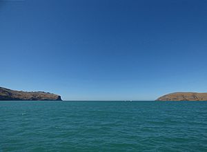
Godley Head (left) and Adderley Head seen from Lyttelton Harbour
|
|
| Location | Christchurch, New Zealand |
| Coordinates | 43°35′17″S 172°48′00″E / 43.588°S 172.800°E |
| Range | Port Hills |
| Offshore water bodies | Lyttelton Harbour |
Godley Head, also known by its Māori name Awaroa, is a well-known piece of land that sticks out into the sea. You can find it in Christchurch, New Zealand. It sits right at the entrance to Lyttelton Harbour. This headland was named after John Robert Godley.
Contents
What's in a Name? The History of Godley Head's Names
Godley Head has had a few different names over time. Each name tells a bit about its past.
Māori Names: Awaroa and Otokitoki
The Māori knew this headland as Awaroa. This name means "long river" or "long valley". The wider area around it, near Gollans Bay, was called Otokitoki. This Māori word might mean "the place of the tītoki tree," which is a native New Zealand tree. It could also refer to a type of brown duck or a small New Zealand bird called a dabchick.
French Name: Cachalot Head
In 1838, a French whaler ship named Cachalot had an accident near this spot. Because of this event, early French explorers started calling the headland Cachalot Head.
English Name: Godley Head
Later, in 1849, Captain Joseph Thomas explored the Canterbury area. He was the main surveyor for the Canterbury Association. Captain Thomas decided to rename the headland Godley Head.
Where is Godley Head Located?
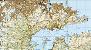
Godley Head is the very eastern end of the Port Hills. It forms the northern side of the entrance to Lyttelton Harbour. On the southern side of the harbour entrance, you'll find another headland called Adderley Head.
The closest town to Godley Head is Te Onepoto / Taylors Mistake. You can walk to Godley Head along Pilgrims Way, which goes past the small holiday homes at Boulder Bay. Since the late 1920s, you can also drive there using the Summit Road.
A Look Back: History of Godley Head
For a long time, people didn't live on top of Godley Head. This was because the land is very open and there was no easy way to get fresh water. This is why there are no signs of early Māori settlements there.
Railway Plans
In the 1850s, people talked a lot about how to build a railway line between Christchurch Central City and Lyttelton. A British engineer named George Robert Stephenson was asked for his advice. He looked at the idea of building a railway along Godley Head at sea level. But he said it would be "useless and unprofitable." Instead, he suggested a "direct route," which became the Lyttelton Rail Tunnel.
The Godley Head Lighthouse
Captain Thomas thought Godley Head would be a perfect spot for a lighthouse back in 1849. The Canterbury Provincial Council agreed in 1859 and set aside money for the project. The lighthouse was finally lit and started working on March 1, 1865. It helped guide ships safely into Lyttelton Harbour.
Godley Head as a Military Base
In 1939, during a time of war, the New Zealand army built a coastal defence site at Godley Head. This was a place to protect the coast. At its busiest, about 400 soldiers were stationed there. The military base was closed in 1963.
Camping at Godley Head
Today, the Department of Conservation (DOC) owns the land at Godley Head. In October 2016, DOC opened a simple campground there. It has 25 spots for tents and camper vans, letting people enjoy the beautiful views and history of the area.
Images for kids
 | Sharif Bey |
 | Hale Woodruff |
 | Richmond Barthé |
 | Purvis Young |


