
Akaroa Harbour facts for kids
Quick facts for kids Akaroa Harbour |
|
|---|---|

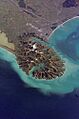
A photo of Akaroa Harbour from the northwest with Ōnawe Peninsula clearly visible
|
|

Akaroa Harbour
Location in New Zealand
|
|

Nautical chart "NZ 6324 Akaroa Harbour"
|
|
| Location | Banks Peninsula |
| Coordinates | 43°50′40.56″S 172°55′30.719″E / 43.8446000°S 172.92519972°E |
| Type | Harbour |
| Islands | The Long Boat |
| Settlements | Akaroa, Duvauchelle, Takapūneke, Takamatua |
Akaroa Harbour is a beautiful natural harbour located on Banks Peninsula in the Canterbury area of New Zealand. It is one of two large inlets on the peninsula. The other is Lyttelton Harbour.
The harbour stretches inland from the southern coast of Banks Peninsula. It mainly goes in a northerly direction.
The name Akaroa comes from the Kāi Tahu dialect of the Māori language. It means "Long Harbour".
In the mid-1800s, the harbour was used for whaling. Both ships and people on shore hunted whales. Today, large Cruise ships sometimes visit the harbour. Passengers often go ashore to explore the town of Akaroa.
At the very end of the harbour is Ōnawe Peninsula. This was once the site of a Māori pā, which was a fortified village.
Towns and Villages
People have lived along the shores of Akaroa Harbour since the 1840s.
Several towns and villages are located on the harbour's waterfront. These include Akaroa, Duvauchelle, Takapūneke, Takamatua, Barrys Bay, French Farm, and Wainui.
These places are connected to the rest of Canterbury by State Highway 75. French Bay, where the French first settled Akaroa, was originally known as Paka Ariki.
Nature and Geography
Akaroa Harbour was formed a very long time ago. It is one of two eroded centres of the extinct Banks Peninsula Volcano. This means it was once part of a giant volcano that is no longer active.
The Akaroa Marine Reserve covers 475 hectares (about 1,174 acres) of the harbour. This special area was approved in 2013. It took 17 years of effort to get it established. The reserve helps protect the marine life in the harbour.
As of 2011, the water quality in the harbour was generally good. Seven different spots are tested regularly. Six of these spots were rated "good" for swimming and other fun activities. One spot was rated "fair." Heavy rainfall can sometimes affect the water quality.
Images for kids
-
Akaroa Harbour's position within the Banks Peninsula Volcano
-
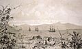
Ships in Akaroa Harbour in the early 19th century. Some Māori whare (houses) are in the foreground.
-
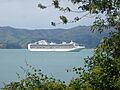
The Sapphire Princess cruise ship in Akaroa Harbour (October 2010).
-
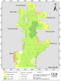
A map showing the holding ground (where ships can drop anchor) in the harbour.


See also
 In Spanish: Puerto de Akaroa para niños
