Cashmere, New Zealand facts for kids
Quick facts for kids Cashmere |
|
|---|---|

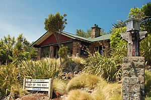
Sign of the Kiwi at Dyer's Pass
|
|
| Basic information | |
| Local authority | Christchurch |
| Electoral ward | Cashmere |
| Land area | 472 ha (1.82 sq mi)* |
| Coordinates | 43°34′22″S 172°37′52″E / 43.572751°S 172.631100°E |
| Population | 6720 (June 2022) |
| Facilities | |
| Hospitals(s) | Princess Margaret Hospital |
| Surrounds | |
| North | Somerfield |
| Northeast | Beckenham |
| East | Huntsbury |
| South | (Port Hills) |
| West | Cracroft |
| Northwest | Hoon Hay |
Cashmere is a lovely suburb located on the southern edge of Christchurch, a big city in New Zealand's South Island. It sits on hills, giving it great views!
Contents
Exploring Cashmere's Location
Cashmere is found on the northern side of the Port Hills. It's right above the end of Colombo Street, which is a main road in Christchurch. This suburb is about 5 kilometers south of the city center. From places like Victoria Park, you can see amazing views of the whole city! Even higher than Victoria Park is a peak called Sugarloaf. This peak is 496 meters tall. It's home to a 119-meter tower that sends out signals for local radio and TV stations.
A Look at Cashmere's Past
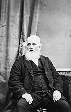
Cashmere got its name from a farm owned by Sir John Cracroft Wilson. His farm covered the area where the suburb is today. Sir John was born in India. He named his farm after a region there called Kashmir. "Cashmere" is an older way of spelling Kashmir. The house Sir John built for his workers from India is now a place for events. It's called The Old Stone House. It's currently being fixed after some earthquakes. Cashmere is known as one of the more well-off suburbs in New Zealand. A census in 2006 showed that people living here generally earned higher incomes.
Important Buildings and Places
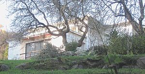
Cashmere is home to two special rest houses built by Harry Ell. These are the Sign of the Takahe and the Sign of the Kiwi. Both are very old and important buildings. The former home of Dame Ngaio Marsh is also in Cashmere. She was a famous writer. Her house in Valley Road is now a museum. It's also a very important historical site. Princess Margaret Hospital was built in 1959. People once thought it would be Christchurch's main hospital. But it was too far from the city center. The Cashmere Club is a popular spot for many local sports. You can find groups for rugby, soccer, bowls, badminton, darts, squash, and even small bore rifle shooting there. Deep underground, in the Cracroft Caverns, is the Canterbury Ring Laser facility. These caverns were built during World War II as an underground bunker. If you love adventure, the Christchurch Adventure Park is in Cashmere. It's a mountain bike park that opened in December 2016.
Who Lives in Cashmere?
Cashmere covers an area of about 4.72 square kilometers. In 2018, it had an estimated population of about 6,453 people. This means there were roughly 1,367 people living in each square kilometer.
| Year | Population |
|---|---|
| 2006 | 6,333 |
| 2013 | 6,135 |
| 2018 | 6,453 |
At the 2018 New Zealand census, Cashmere had 6,453 residents. This was an increase of 318 people since the 2013 census. It was also 120 more people than in the 2006 census. There were 2,394 homes in Cashmere. There were slightly more females (3,255) than males (3,198). About 1,206 people (18.7%) were under 15 years old. About 1,017 people (15.8%) were aged 15 to 29. Most people, 3,084 (47.8%), were aged 30 to 64. And 1,149 people (17.8%) were 65 or older. Most people in Cashmere (92.4%) were European/Pākehā. Other groups included Māori (4.4%), Pacific peoples (0.8%), and Asian (5.3%). Some people identified with more than one group. About 24.9% of people in Cashmere were born overseas. This is a bit less than the national average of 27.1%. When asked about religion, 55.9% said they had no religion. About 34.6% were Christian. Other religions included Hindu (0.3%), Muslim (0.5%), and Buddhist (1.0%). Many adults in Cashmere have a good education. About 2,274 people (43.3%) aged 15 or older had a university degree or higher. Only 411 people (7.8%) had no formal qualifications. For jobs, 2,658 people (50.7%) worked full-time. Another 990 people (18.9%) worked part-time. About 120 people (2.3%) were unemployed.
| Name | Population | Homes | Average Age | Average Income |
|---|---|---|---|---|
| Cashmere West | 3,060 | 1,116 | 44.6 years | $45,300 |
| Cashmere East | 3,393 | 1,278 | 43.4 years | $45,500 |
| New Zealand | 37.4 years | $31,800 |
Schools in Cashmere
Cashmere has two primary schools:
- Cashmere Primary Te Pae Kererū is a school for students in years 1 to 8. It has about 396 students. The school first opened in 1900 as Port Hills Aided School. It moved to its current location in 1905 and changed its name to Cashmere School in 1907.
- Te Kura o Huriawa Thorrington is a primary school for students in years 1 to 6. It has about 391 students. This school opened in 1958.
Both schools welcome both boys and girls. The student numbers are from February 2024. .
Famous People From Cashmere
Some well-known people have lived in Cashmere:
- Ursula Bethell (1874–1945), a famous poet.
- Fanny B. Cole (1860-1913), who was a national leader for the Women's Christian Temperance Union New Zealand.
- Ruth Dyson (born 1957), a politician.
- Norman Hardie (born 1924), a mountaineer.
- T.E. "Tommy" Taylor (1862-1911), a politician.
- John Cracroft Wilson (1808–1881), who was a Member of Parliament.
 | Bessie Coleman |
 | Spann Watson |
 | Jill E. Brown |
 | Sherman W. White |


