
Te Heru o Kahukura / Sugarloaf facts for kids
Quick facts for kids Sugarloaf communications tower |
|
|---|---|

The Sugarloaf communications tower viewed from Bowenvale Valley
|
|
| Highest point | |
| Elevation | 493.78 m (1,620.0 ft) |
| Geography | |

Te Heru o Kahukura / Sugarloaf
Location in Christchurch, New Zealand
|
|
| Location | Christchurch, New Zealand |
| Geology | |
| Mountain type | Basalt volcanic rock |
Te Heru o Kahukura / Sugarloaf is a famous landmark in the Port Hills near Christchurch, New Zealand. Its name, "Te Heru o Kahukura," means "the headcomb of Kahukura." On top of this hill stands the Sugarloaf communications tower, a tall mast that sends out radio and television signals.
Contents
Where is Sugarloaf Tower?
The Sugarloaf communications tower is located on top of the Port Hills, about 494 meters (1,620 feet) above sea level. This area is known as the Sugarloaf Scenic Reserve. It's a beautiful spot that sometimes doubles as a sheep farm. There's also a car park lookout point where visitors can enjoy amazing views.
About the Communications Tower
In 1965, the New Zealand Broadcasting Corporation (now called Television New Zealand) rented a piece of land on Sugarloaf Hill. They built the communications tower and a control building there. The tower is 121 meters (397 feet) tall and is made of strong steel. It stands on a deep concrete base, which rests on volcanic rock. This tower, along with its building, can be seen from most parts of Christchurch city.
What the Tower Looks Like Up Close
If you look closely at the red and white tower, you'll see many different antennas. These include dish-shaped antennas, dipoles, and microwave links. The tower has three main platforms for technicians to work on, with ladders running up the side. At night, the tower lights up with three red beacons. Two of these lights are steady, while the top one flashes on and off. On a clear night, you can often see these lights from the city, along with some light from inside the main building.
The Transmission Building
About 50 meters (164 feet) behind the tower is a single-story building. This building holds all the important equipment that helps send out signals. The main room, called the "great transmitter hall" by technicians, is kept cool with air conditioning. The building is about 40 meters (131 feet) wide and 20 meters (66 feet) deep. On its roof, you can see satellites, small antennas, and more dish antennas used for private Wi-Fi networks. Thick cables connect this building to the tower. This building has not had people working inside it for several years.
Visiting the Tower Area
The entire area around the tower is protected by a security fence and a thick hedge. Only authorized people are allowed inside the site, and climbing the tower is strictly forbidden. Vehicles can only enter the site through a locked gate. However, there is a public car park lookout point about 200 meters (656 feet) in front of the tower. From here, you can see wide views of Canterbury. The public can visit this reserve until about 6:00 PM, when the gate is locked for the night.
How the Tower Works
The Sugarloaf tower has six main antennas that send out TV and FM radio signals. These signals cover a wide range, from 45 MHz to 800 MHz. The total power sent to all the antennas is about 64 kW. Many different services use this tower, including television, radio, emergency services, aviation, and mobile phone signals.
The tower's signals reach most of Christchurch and central Canterbury. For example, digital TV signals go as far north as Waipara, west to the Southern Alps foothills, and south to the Rangitata River. However, not all areas in central Canterbury get good coverage. Places like Akaroa often have poor TV and radio reception. Also, the Christchurch suburbs of Redcliffs and Sumner have limited coverage from Sugarloaf. For these areas, radio signals are sent through a smaller, local repeater in Southshore.
TV and Radio Frequencies
Here are the television and radio frequencies currently broadcast from Sugarloaf:
| TV Channel | Transmit Channel | Transmit Frequency | Band | ERP (kW) |
|---|---|---|---|---|
| World TV digital | 28 | 530 MHz | UHF | 50, horizontal |
| MediaWorks digital | 32 | 562 MHz | UHF | 50, horizontal |
| TVNZ digital | 34 | 578 MHz | UHF | 50, horizontal |
| Kordia digital | 36 | 594 MHz | UHF | 50, horizontal |
| Māori TV digital | 38 | 610 MHz | UHF | 50, horizontal |
| Radio Station | Transmit Channel | Transmit Frequency | Band | ERP (kW) |
| The Edge | 88.9 MHz | VHF | 32, mixed | |
| RNZ Concert | 89.7 MHz | VHF | 80, mixed | |
| Tahu FM | 90.5 MHz | VHF | 16, mixed | |
| ZM | 91.3 MHz | VHF | 80, mixed | |
| More FM | 92.1 MHz | VHF | 80, mixed | |
| The Sound | 92.9 MHz | VHF | 50, slant | |
| The Rock | 93.7 MHz | VHF | 80, mixed | |
| The Breeze | 94.5 MHz | VHF | 32, mixed | |
| Mai FM | 95.3 MHz | VHF | 32, mixed | |
| The Garage 96.1 (New Zealand Broadcasting School) |
96.1 MHz | VHF | 16, mixed | |
| Plains FM | 96.9 MHz | VHF | 5, slant | |
| The Hits | 97.7 MHz | VHF | 80, mixed | |
| Magic Music | 99.3 MHz | VHF | 32, mixed | |
| Newstalk ZB | 100.1 MHz | VHF | 5, mixed | |
| RNZ National | 101.7 MHz | VHF | 16, mixed | |
| Niu FM | 104.1 MHz | VHF | 16, mixed | |
| Radio Hauraki | 106.5 MHz | VHF | 16, mixed |
Old Analogue TV Frequencies
The following frequencies were used until April 28, 2013. On that date, Sugarloaf stopped sending out analogue TV signals.
| TV Channel | Transmit Channel | Transmit Frequency | Band | Power (kW) |
|---|---|---|---|---|
| TV One | 3 | 62.2396 MHz | VHF | 100 |
| TV3 | 6 | 189.2604 MHz | VHF | 320 |
| TV2 | 8 | 203.25 MHz | VHF | 320 |
| Four | 11 | 224.239575 MHz | VHF | 200 |
| CTV | 44 | 655.25 MHz | UHF | 25 |
| Māori Television | 46 | 671.2604 MHz | UHF | 320 |
| Prime | 62 | 799.25 MHz | UHF | 320 |
Images for kids
- Sugarloaf Mountain communications tower
-
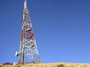
The Sugarloaf Communications tower stands 121 m high.
-
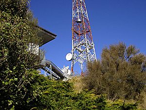
Sugarloaf Communications Tower showing cable runs from back of building to base of tower.
-
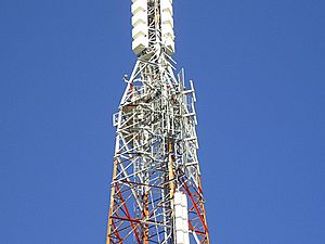
Close up view of Sugarloaf Communications Tower.
-
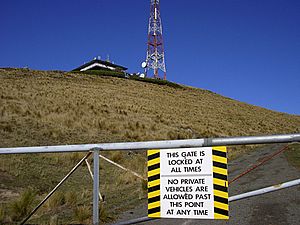
A gate prevents access to the transmitter site for private vehicles.
-
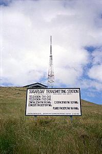
View of the tower from the carpark in 1990, showing old signage.


Who Manages the Tower?
The Sugarloaf tower and its building are currently owned and looked after by a company called Kordia. This company used to be known as Broadcast Communications Limited (BCL NZ).
