Tauhinukorokio / Mount Pleasant facts for kids
Quick facts for kids Mount Pleasant |
|
|---|---|
| Tauhinu Korokio | |

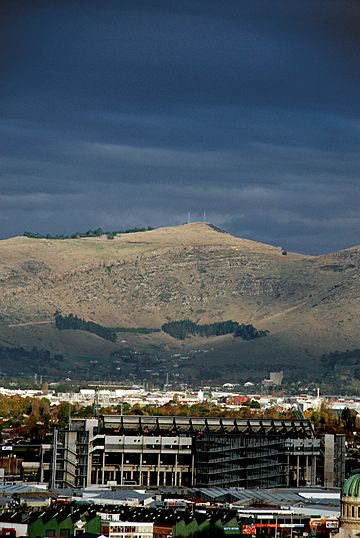
A view of Mount Pleasant, with AMI Stadium in the foreground (From Hotel Grand Chancellor, demolished after the 2011 Christchurch earthquake)
|
|
| Highest point | |
| Elevation | 499 m (1,637 ft) |
| Geography | |
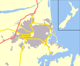
| Location | Christchurch |
| Parent range | Port Hills |
| Geology | |
| Mountain type | Basalt volcanic rock |
Mount Pleasant (Māori: Tauhinu Korokio or Tauhinukorokio) is the tallest peak in the eastern Port Hills near Christchurch, New Zealand. Long ago, it was home to a Māori pā, which was like a fortified village. By the time European settlers arrived in the 1840s, not much of the pā remained.
The hill was first used for grazing sheep. It also became an important "trig station," a fixed point used by surveyors to create maps of the Canterbury area. People also used Mount Pleasant as a signal station. They would light fires or raise flags to let residents know when ships were arriving in Lyttelton Harbour. During World War II, a large anti-aircraft gun battery was built near the top. You can still see the foundations of these old buildings today.
Contents
Where is Mount Pleasant?
Mount Pleasant is part of the Port Hills, a range of hills formed by ancient volcanoes. It stands at 499 metres (1,637 ft) (about 1,637 feet) high.
On the northern side of the hill, you'll find the Christchurch suburb also called Mount Pleasant. On its southern side, the hill overlooks the beautiful Lyttelton Harbour.
What Does the Name Mount Pleasant Mean?
Māori Name: Tauhinu Korokio
The Māori name for the hill is Tauhinu Korokio. This name comes from two native New Zealand plants.
- Tauhinu is a type of cottonwood plant (Ozothamnus leptophyllus).
- Korokio is a densely branched shrub (Corokia cotoneaster).
In September 1948, the New Zealand Geographic Board officially changed the name to Tauhinukorokio/Mount Pleasant.
European Name: Mount Pleasant
The name "Mount Pleasant" was given by the crew of a ship called HMS Pegasus in 1809. They were surveying the coast of Canterbury at the time.
Later, in 1848, Joseph Thomas, a chief surveyor, climbed the mountain. He knew its European name but decided to rename it Mount Cavendish. He did this to honor Lord Richard Cavendish, who was part of the Canterbury Association, a group that helped settle the area. However, the name Mount Cavendish did not become popular for this hill. Instead, it was later given to a nearby hill.
A Look Back: History of Mount Pleasant
Early Māori History
Long ago, the hill was home to a pā (fortified village) belonging to the Ngāti Māmoe people. About 300 years ago, another Māori tribe, Ngāi Tahu, led by Te Rakiwhakaputa, took control of the pā. When the first European settlers arrived, they could still see the remains of this old pā near the peak.
Surveying Canterbury
Captain Thomas, the chief surveyor for the Canterbury Association, chose Mount Pleasant as a key "trig station." This was a very important point for surveying and mapping the new Canterbury settlement.
Early European Farmers
The first European to farm on Mount Pleasant was Joseph Greenwood. He started farming there in 1846 and built a small hut near the top. In 1847, he sold his land to the Rhodes brothers, William Barnard and George.
Edward Ward, one of the "Pilgrims" (early settlers who arrived on the ship Charlotte Jane), climbed Mount Pleasant in 1850. He wanted to see the Canterbury Plains. He stood by a hut managed by Charles Crawford, who worked for the Rhodes brothers. Ward was amazed by the plants and springs he saw. He even wished he could buy the hut and the land!
Ward later bought Quail Island instead. Sadly, he and his brother Henry drowned in Lyttelton Harbour in 1851.
Major Hornbrook's Signal Station
Major Alfred Hornbrook arrived in Lyttelton in 1849. He bought Mount Pleasant from the Rhodes brothers in 1852. Major Hornbrook was known for being a bit unusual, but he was also very helpful to the community.
He would signal all ships arriving in Lyttelton Harbour from the top of Mount Pleasant. In 1853, people in the community raised money to buy him a telescope, a flagstaff, and flags for this important job. The walking path from Mount Cavendish down to Lyttelton, which Major Hornbrook used to get supplies, is still called Major Hornbrook's Track today.
Major Hornbrook faced financial difficulties in 1871. He owned many sheep, including 6,000 on his Mount Pleasant farm. His land was then sold to Richard May Morten and William White. Morten later bought the land himself in 1879.
Subdivision and Development
After Morten passed away in 1909, his large land area of about 6,500 acres (2,600 ha) was divided up. Some land was set aside for roads, like the Summit Road, and other public uses. The rest was sold off in smaller sections for building homes and small farms.
The old Hornbrook homestead, which was just below the summit, burned down before World War I. In its place, tearooms and accommodation opened in March 1914. These buildings are still there today, just above where Mount Pleasant Road meets the Summit Road, but they are no longer open to the public.
World War II Battery
Between late 1942 and early 1943, a large anti-aircraft artillery (HAA) battery was built near the summit of Mount Pleasant. This battery was designed to protect the area from air attacks during World War II. A total of 91 buildings were put up, and soldiers staffed the battery from January 1943 to September 1944. However, it was never used in actual combat.
This Mount Pleasant battery is special because it's the only one of the 21 HAA batteries built in New Zealand (outside of Wellington) that still has its foundations remaining.
After the war, the New Zealand Post Office used the peak for radio services, helping with communication for mobile radios.
 | Frances Mary Albrier |
 | Whitney Young |
 | Muhammad Ali |


