
Arthur's Pass (mountain pass) facts for kids
Quick facts for kids Arthur's Pass |
|
|---|---|

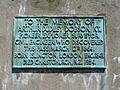
Sir Arthur Dudley Dobson memorial
|
|
| Elevation | 920 m (3,018 ft) |
| Traversed by | New Zealand State Highway 73 |
| Location | New Zealand |
| Range | Southern Alps |
| Coordinates | 42°54′11.272″S 171°33′42.221″E / 42.90313111°S 171.56172806°E |
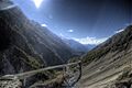
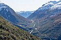
Arthur's Pass is a famous mountain pass in the Southern Alps of New Zealand's South Island. It sits high up, about 920 meters (or 3,018 feet) above sea level. This pass marks part of the border between the West Coast and Canterbury areas.
Arthur's Pass is located about 140 kilometers (87 miles) from Christchurch and 95 kilometers (59 miles) from Greymouth. It connects the valleys of the Otira River in the west and the Bealey River in the east. A small township with the same name, Arthur's Pass, is located about 5 kilometers (3 miles) south of the mountain pass itself.
Contents
Exploring Arthur's Pass: A Journey Through Time
For hundreds of years, the Māori knew about and used mountain passes to cross the Southern Alps. They traveled during the summer when the passes were free of snow. Their main reason for these tough journeys was to find pounamu, also known as greenstone. This special stone was highly valued for its strength and beauty, and it could only be found on the West Coast of the South Island.
By the time Europeans arrived, the pass most often used by Māori was Harper Pass, which is north of Arthur's Pass.
Early European Explorers
In 1857, a man named Leonard Harper was guided by Māori across Harper Pass. The Māori chief Tarapuhi told him about another route over the mountains at the top of the Otira River. This route hadn't been used in a very long time. Bad weather stopped Harper from exploring it on his way back.
In 1860, the writer and explorer Samuel Butler saw a pass at the top of the Bealey Valley. However, he was traveling with his horse and didn't want to leave it alone, so he didn't investigate further.
The Dobson Brothers' Discovery
In 1863, Arthur Dudley Dobson (1841–1934) went to the mostly unknown West Coast to do survey work. His job was to map the area from the Grey River to Abut Head, and inland towards the Main Divide of the Southern Alps. His brother, Edward Dobson, was busy clearing a rough track over Harper Pass.
Arthur Dobson returned to Christchurch and told the chief surveyor, Thomas Cass, what he had found. Cass then asked Arthur Dobson in 1864 to find a good pass from the Waimakariri area to the West Coast.
Arthur and his brother George started their journey in March 1864. Their brother Edward joined them later at Craigieburn. While George surveyed roads, Edward and Arthur explored the high country. On March 13, 1864, they found the pass that Tarapuhi had told Harper about. This pass dropped steeply down to what became known as Otira. They explored the gorge but didn't find good land for sheep, so they turned back. Arthur wrote a report and drew a sketch of the pass. He called it the "Arahura Saddle," thinking it led to the Arahura River.

The Gold Rush and Road Building
Soon after, gold was discovered, starting the West Coast Gold Rush. This meant people needed a good way to get to the gold fields. The provincial engineer, who was Arthur and Edward's father, Edward Dobson, was asked to check every possible pass to the West Coast. After looking at all of them, he said that "Arthur's pass" was the best way to reach the gold fields.
The government decided to build a road between Christchurch and Hokitika, which was about 156 miles (251 kilometers) long. Edward Dobson was put in charge of this big project. The road was officially opened on March 20, 1866. The alpine pass became known as Arthur's Pass, and a nearby village and later a national park also took this name.
Traveling Through Arthur's Pass
Arthur's Pass is an important route for both cars and trains.
The Road Over the Pass
State Highway 73 goes right over Arthur's Pass. It is one of only three roads that cross the Southern Alps. The other two are the Haast Pass and the Lewis Pass. Interestingly, Porters Pass, which is on the same road, is actually a bit higher (at 939 meters or 3,081 feet) than Arthur's Pass. However, Porters Pass is not considered an "alpine pass" because it's in the Canterbury foothills, not far from Springfield.
The road on the western side of Arthur's Pass used to have problems with landslides and avalanches. But in the late 1990s, a lot of engineering work was done to make it safer. The most impressive part of this work is the Otira Viaduct. This huge bridge, near the small town of Otira, spans 440 meters (1,444 feet) over tricky ground and was finished in 1999.
The Rail Link Through the Mountains
The Midland Line is a train track that connects Christchurch with the West Coast. This railway crosses the Main Divide of the Southern Alps by going through the Otira Tunnel. This tunnel is located between the Arthur's Pass township and Otira. When it opened in 1923, the Otira Tunnel was the longest railway tunnel in the entire British Empire!
Images for kids
-
Otira Viaduct
-
Memorial inscription
-
Arthur's Pass
-
Boundary marker


See also
 In Spanish: Paso de Arthur para niños
