
Arthur's Pass National Park facts for kids
Quick facts for kids Arthur's Pass National Park |
|
|---|---|
|
IUCN Category II (National Park)
|
|

Arthur's Pass National Park
Location in New Zealand
|
|
| Location | Canterbury, New Zealand |
| Nearest city | Christchurch, New Zealand |
| Area | 1,184.7 km2 (457.4 sq mi) |
| Established | 1929 |
| Governing body | Department of Conservation |


Arthur's Pass National Park is a huge park in the South Island of New Zealand. It covers about 1,185 square kilometres. Most of this land is made up of mountains. It's a place of amazing natural beauty, with tall peaks, deep valleys, and rushing rivers.
Contents
History of Arthur's Pass National Park
Arthur's Pass National Park was created in 1929. It was the first national park in the South Island. It was also the third national park in all of New Zealand. Some land, like Arthur's Pass and the Ōtira Gorge, was protected even earlier. This protected land became the start of the national park.

In the 1920s, people started taking train trips to Arthur's Pass. They loved to collect native flowers as souvenirs. Some even cut down trees to get beautiful rātā blooms. People soon realised that the area needed more protection. This led to the park being officially established in 1929.
At first, the park didn't have much funding. It took a few years for the plants and animals to be fully protected. The first full-time park ranger, Ray Cleland, started in 1950. He had many jobs, like building huts and tracks. He also helped promote the park and keep it safe. The first visitor centre was built in 1959. It was made from local stone to match the park's natural look.
Geography of Arthur's Pass

State Highway 73 cuts right through Arthur's Pass National Park. This road goes through Arthur's Pass village and over the mountain pass. The pass is 920 metres high in the Southern Alps. The park is looked after by the Department of Conservation. They have an office and information centre in Arthur's Pass village.
The park is divided by the main mountain range of the South Island. The eastern side is usually drier. It has mountain beech forests and wide riverbeds. The western side gets more rain. It has thick rainforests with different types of trees. The landscape was shaped by ancient glaciers. They carved out wide, U-shaped valleys. In the middle are high, snowy peaks and rocky slopes.
The park has many cool natural features:
- Several mountain passes, including Harman, Waimakariri Col, Arthur's, Goat, Tarahuna, Worsley, Minchin, and Harper.
- The start of the Waimakariri River, near the Waimakariri Falls Hut.
- Many rivers that flow into the Waimakariri River. These include the Bealey, Poulter, Hawdon, White, Crow, and Anti Crow Rivers.
- Several rivers that flow into the Taramakau River. These are the Otira, Deception, and Otehake Rivers.
- Mt Murchison is the highest peak in the park. It stands at 2400 metres tall.
Fun Activities in the Park
Arthur's Pass National Park is a great place for outdoor adventures. People love to go tramping (which is like hiking), skiing, hunting, and mountaineering. The Mingha-Deception tramping route is used every February. It's part of the running section for the famous Coast to Coast race.
Avalanche Peak
Avalanche Peak is special because it's the only peak in the park with a marked path to the top. The climb is steep, going up 1100 metres from Arthur's Pass village. On a clear day, you get amazing views of the Southern Alps from the summit.
Devils Punchbowl Waterfall

The Devils Punchbowl waterfall is near the northern end of Arthur's Pass Village. You can walk to it in under two hours. The path starts at a footbridge over the Bealey River. The walk goes through a beautiful beech forest, where you can spot many birds. The track climbs up to a viewing platform at the base of the 131-metre waterfall.
Mount Rolleston
Mount Rolleston is one of the highest peaks in the National Park. It is 2271 metres tall. It's a popular mountain for climbers, with several ways to reach the top. The Rolleston Glacier on the mountain has been melting a lot. Scientists say this is happening much faster because of climate change.
Bealey Spur Track


This track is a popular day trip in Arthur's Pass National Park. It's an easy 2.5-hour walk up to the Bealey Spur Hut. On a clear day, the views over the Waimakariri Basin and the mountains are fantastic.
Edwards-Hawdon Tramping Track

This is a challenging tramping trip. It goes up the Edwards River, crosses two alpine passes, and then goes down the Hawdon River. The Department of Conservation says it shows "the best of Arthur's Pass National Park's stunning alpine landscapes." It's usually a two-night, three-day trip. You can stay at Edwards Hut and Hawdon Hut. This trip is only for very experienced tramping groups.
Andrews-Poulter Tramping Track

The Andrews-Poulter is a popular trip on the eastern side of Arthur's Pass National Park. It crosses two passes. The first is Casey Saddle, surrounded by beech forest, leading to Casey Hut. The second day follows the Poulter River flats. Then it climbs through beech forest to Binser Saddle before going down to the carpark.
Casey Hut burned down in 2015. Fire investigators thought the fire started near the woodstove. Luckily, the fire did not spread to the forest. The original hut was built in 1969 and had 16 bunks. In 2019, two people gave $250,000 to rebuild the hut. The new Casey Hut opened in August 2020. It has cool upgrades like a better fireplace, double-glazed windows, insulation, and solar lighting.
Mingha-Deception Tramping Track
This is a well-known tramping trip. It goes up the Mingha River to Goat Pass. Goat Pass Hut is located at the pass and has 20 bunk beds. The second day involves going down the Deception River and crossing it many times. You can also take a side trip to Lake Mavis from Goat Pass. This trip is used for the mountain run in the Coast to Coast race. There's also work done here to control pests like stoats and rats. This helps protect native birds like the blue duck.
Carroll Hut Track
The Carroll Hut Track is on the west coast side of Arthur's Pass National Park. It's about 3 kilometres north of Otira on State Highway 73. The walk to the hut takes about three hours. It's a steep climb through different types of forest. On a clear day, you get good views of the Taramakau River. The hut has 10 bunk beds and no heating. The trip back from the hut to the road takes about 90 minutes.
Amazing Animals in the Park
Whio
Seventeen Whio (blue ducks) were released into the park in March 2021. There are fewer than 3000 whio left in New Zealand. They are very special native ducks.
Kākāriki Karaka
The orange-fronted parakeet, called Kākāriki karaka, is very rare. It's one of New Zealand's six kākāriki species. You can only find it in Arthur's Pass National Park. They are most often seen in the Hawdon and Poulter valleys.
Kea
Kea are often seen in the park and the village. These smart parrots like to hang out near the tree line on Scotts Track, which leads to Avalanche Peak. Young kea can sometimes be seen from the carpark at the viaduct lookout. This is about 8km west of Arthur's Pass Village. Kea also visit the local ski fields.
Great Spotted Kiwi (Roroa)
You can sometimes hear the calls of the great spotted kiwi, or roroa, around Arthur's Pass Village. But because they are nocturnal, kiwi are often hard to see. There are up to 40 kiwi living in the Bealey Valley.
Weka
Weka are becoming more common on the western side of the park. They are also sometimes seen in the Edwards Valley. Weka were not seen here between the 1920s until the 1970s. Since then, their numbers have grown, especially with efforts to control predators.
Staying Safe in the Park
Arthur's Pass National Park is a wild and beautiful place. It's important to be prepared when you visit. The mountains here can be challenging. Even marked day walks can involve climbing about 1000 metres. These paths often go above the tree line, where you are exposed to the weather. The tracks can be very steep, and sometimes you need to use your hands to pull yourself up.
The weather in the mountains can change very quickly. There are also many cliffs and waterfalls. Some harder routes need special mountaineering skills and equipment. To stay safe, you need to have some experience, knowledge, and the right gear. It's true "back country" here.
Many people visit Arthur's Pass National Park because it's easy to reach from Christchurch. This means that sometimes people who are not fully prepared try to do too much. It's very important to know your limits. Always check the weather forecast. Make sure you have enough warm clothing, food, and water. Carry a map and know how to use it. If you are unsure, it's always best to choose an easier track or go with an experienced guide.
Images for kids
-
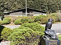
Arthurs Pass Visitor Centre (built 1959, closed 2019). The visitor centre facilities relocated to across the road.
-
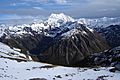
Mount Rolleston (2009)
-
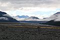
Waimakariri basin


See also
 In Spanish: Parque nacional del Paso de Arthur para niños
