Ōtira River facts for kids
Quick facts for kids Ōtira River |
|
|---|---|

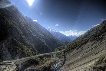
Upper Ōtira River and Ōtira Viaduct
|
|
| Country | New Zealand |
| Physical characteristics | |
| Main source | Mount Rolleston |
| River mouth | Taramakau River |
| Length | 20 km (12 mi) |
The Ōtira River is a river found in the middle of New Zealand's South Island. It starts high up on Mount Rolleston in the Southern Alps / Kā Tiritiri o te Moana mountains. The river flows north for about 20 kilometers (12 miles). It passes by the small town of Otira before joining another river called the Taramakau River. The Taramakau River then flows into the Tasman Sea, which is about 12 kilometers (7.5 miles) south of Greymouth.
The Ōtira River's Journey
The Ōtira River begins its journey on the slopes of Mount Rolleston. This mountain is part of the Southern Alps, a large mountain range in New Zealand. From its source, the river flows mainly north.
It travels for about 20 kilometers (which is about 12 miles). Along its path, the river flows through the area near the small town of Otira. Eventually, the Ōtira River joins the Taramakau River.
Path to the Sea
After the Ōtira River joins the Taramakau River, the combined waters continue their journey. The Taramakau River then flows towards the coast. It empties into the Tasman Sea. The Tasman Sea is the body of water that separates New Zealand from Australia. This meeting point with the sea is about 12 kilometers (7.5 miles) south of a larger town called Greymouth.
Connection to Arthur's Pass
The valley of the Ōtira River is very important. It forms the northwestern path to Arthur's Pass. Arthur's Pass is one of the three main mountain passes that cross the Southern Alps. These passes are like natural doorways through the mountains. The Ōtira River valley makes it easier to travel through this part of the rugged landscape.
See also
 In Spanish: Río Otira para niños
 | Sharif Bey |
 | Hale Woodruff |
 | Richmond Barthé |
 | Purvis Young |

