Porters Pass facts for kids
Quick facts for kids Porters Pass |
|
|---|---|

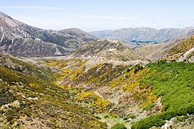
State Highway 73 descending from Porters Pass towards Springfield.
|
|
| Elevation | 939 m (3,081 ft) |
| Traversed by | State Highway 73 |
| Location | New Zealand |
| Range | Southern Alps |
| Coordinates | 43°17′48″S 171°44′31″E / 43.29667°S 171.74194°E |
Porters Pass is a mountain pass in the Canterbury region of New Zealand. It is located on the South Island and reaches an elevation of 939 metres (about 3,081 feet) above sea level.
This pass is found near Lake Lyndon. It is also part of the Korowai/Torlesse Tussocklands Park. The main road, State Highway 73, goes right through Porters Pass. This road connects towns like Springfield and Cass.
Contents
A High Road in the South Island
Porters Pass is a very important part of the road network. It is the last mountain pass you cross when traveling east from Westland towards Christchurch.
How High Is It?
Porters Pass is one of the highest points on the South Island's state highway system. It is the third-highest, right after the Lindis Pass and the Milford Road. It is only one metre lower than the Milford Road's highest point!
Porters Pass vs. Arthur's Pass
You might have heard of Arthur's Pass, which is quite famous. However, Porters Pass is actually a few metres higher than Arthur's Pass. From Porters Pass, you can see amazing views of the wide Canterbury Plains.
Who Named Porters Pass?
The pass was named in 1858. It got its name from the Porter brothers. They were farmers who lived and worked in the area nearby.
 | Sharif Bey |
 | Hale Woodruff |
 | Richmond Barthé |
 | Purvis Young |


