State Highway 94 (New Zealand) facts for kids
Quick facts for kids
State Highway 94 |
||||
|---|---|---|---|---|
 |
||||
| Route information | ||||
| Maintained by NZ Transport Agency | ||||
| Length | 254.4 km (158.1 mi) | |||
| Tourist routes |
Southern Scenic Route |
|||
| Major junctions | ||||
| Southeast end | ||||
| Northwest end | Milford Sound | |||
| Location | ||||
| Primary destinations: |
Riversdale, Lumsden, Mossburn, Te Anau, Homer Tunnel | |||
| Highway system | ||||
|
||||
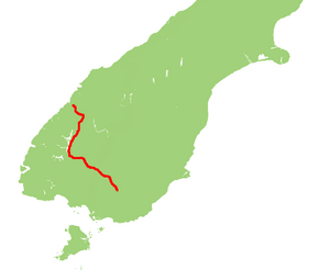
State Highway 94 is a major road in New Zealand. It connects the town of Gore in the Southland area to Milford Sound. Milford Sound is one of New Zealand's most famous places to visit.
This highway also goes through important towns like Lumsden and Te Anau. A special part of the road is called the 'Milford Road'. This section includes the famous Homer Tunnel. The Milford Road part is about 119 kilometers long, starting from Te Anau.
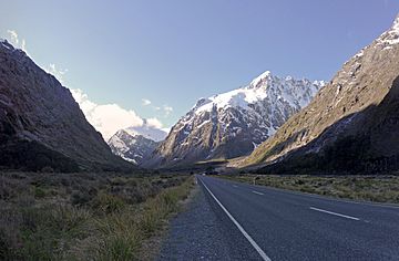
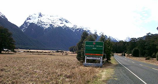
The highway also travels through Fiordland and crosses the main mountain range, the Southern Alps. Many people think it's one of the most beautiful roads in New Zealand. It reaches a high point of 940 meters. This makes it the third highest highway in the country.
It's a very beautiful road, but it's also important to drive carefully. The Milford Road section can be challenging. It's always a good idea to be prepared and drive safely.
Contents
Building the Road: A Look Back
The idea for this road started a long time ago. In 1890, an engineer named Robert Holmes first planned the route. He later became a top engineer for the government. He first thought about starting the road from Lake Wakatipu. But they decided to start it from Te Anau instead.
From Idea to Reality: A Long Journey
After the first plans, the project didn't move forward for 40 years! Building roads was taken away from the Public Works Department for a while. It wasn't until 1935 that a rough road reached the spot where the Homer Tunnel would be.
The tunnel itself was built by hand. Workers used picks and shovels. Many of these workers were sent there by the government during the Great Depression. Life was very tough for them. Sadly, some workers even lost their lives in avalanches in the 1930s.
The tunnel was finally dug all the way through in February 1940. But World War II caused more delays. There weren't enough workers to finish the job. So, the Homer Tunnel wasn't fully completed until 1953.
Modern Upgrades for a Safer Road
For many years, large parts of the Milford Road, including the tunnel, were covered in gravel. They weren't sealed with pavement until the 1980s.
Today, improvements are still being made to the Homer Tunnel. The goal is to keep this important tourist route open as much as possible. For example, the western entrance of the tunnel was recently extended. This helps to protect it from avalanches.
Exploring the Route of State Highway 94
Here's how State Highway 94 travels across the South Island.
From Gore to Te Anau: Farms and Rivers
In Gore, SH 94 starts as Hokonui Drive. It goes through the northern part of the town. Outside Gore, the road changes its name to Waimea Highway. It passes north of the Hokonui Hills. This area was once famous for making illegal alcohol.
Then, the road turns right and crosses the Waimea Plains. It goes through small towns like Riversdale and Balfour. The road continues northwest to Lumsden.
From Lumsden, SH 94 joins up with SH 6 for about 2.5 kilometers. They run together towards Queenstown. Then, SH 94 turns left, crosses the Oreti River, and goes back onto the plains.
It travels another 20 kilometers to Mossburn. Mossburn calls itself the "deer capital of New Zealand." Many tourists from Queenstown join SH 94 here. After Mossburn, the road changes its name again. It passes through farmland and near the turnoff to Mavora Lakes. This was one of the places used in The Lord of the Rings movies! The road then goes into rolling hills before reaching Te Anau.
From Te Anau to Milford Sound: The Milford Road Adventure
In Te Anau, the road becomes Luxmore Drive and then Milford Road. Outside town, it's called Te Anau Milford Highway. The road follows the edge of Lake Te Anau for about 29 kilometers. It skirts the edge of Fiordland National Park.
From Te Anau Downs, the road enters the beautiful Eglinton Valley. It officially enters the national park about 45 kilometers north of Te Anau. It runs alongside the Eglinton River for 33 kilometers, passing through Knobs Flat. A popular stop for buses is at Mirror Lakes. It's about halfway between Te Anau and Milford Sound.
At Cascade Creek, you'll find the closest camping ground to Milford Sound. The road then reaches the shores of Lake Gunn and Lake Fergus. It passes through a low point called "The Divide." This is where the Routeburn Track ends. The Divide marks the line where rivers flow to either the west or east coast. It's only 532 meters high here.
After The Divide, the Milford Road enters the upper part of the Hollyford Valley. It then goes down into the valley, leading to the turn-off for the Hollyford Track.
The road then climbs steadily to the top of the valley. This area is like a huge bowl surrounded by tall cliffs. This spot, at the eastern entrance of the Homer Tunnel, is the highest point of Milford Road at 945 meters.
The Homer Tunnel is wide enough for two lanes. But during busy summer times, traffic lights control it to one direction at a time. This can cause delays of up to 20 minutes. At 1270 meters long, the Homer Tunnel is the third-longest road tunnel in New Zealand.
On the western side of the tunnel, the road comes out into the Cleddau Valley. This valley is U-shaped, which is common in Fiordland's fiords. The road goes steeply down with three sharp turns. Then it follows the valley floor for its last 16 kilometers to sea level at Milford Sound. Along the way, you'll pass The Chasm, which has a short walking track to a waterfall. At the end of the road in Milford Sound, there's parking for cars and tour buses.
Fun Things to See Along the Way
The Milford Road section became a tourist highlight in 1926. A local landowner started building his own road from Te Anau Downs Harbour. This project grew into one of New Zealand's most scenic highways.
Famous Landmarks and Movie Magic
Along the Milford Road, you can see amazing places like the Mirror Lakes, Lake Gunn, the Key Summit, Mount Christina, Mount Talbot, the Homer Tunnel, The Chasm, Mount Tūtoko, and Mitre Peak. Before the road was sealed in the 1980s, visiting Milford Sound was a full day's adventure from Te Anau.
This route is also part of the Te Waipounamu Wilderness Area.
The Eglinton Mountains above Lake Gunn were used in Peter Jackson's movie The Fellowship of the Ring. The actors walked along a mountain path with the Key Summit in the background. These mountains also appeared in the movie's introduction as the Misty Mountains. Emily Peak on the Routeburn Track and the Mavora Lakes near Mossburn were also used in the film.
Hidden History and Cool Stops
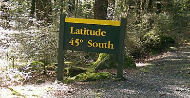
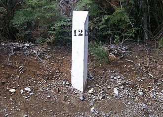
There are many interesting historical spots not marked by signs. These include the Cleddau Horse Bridge and the old Homer Tunnel construction village site. However, the historic White Mile Posts are still there. They show how the Milford Road was built long ago. The Department of Conservation still keeps up the Latitude 45 South Marker.
You'll find car parks at popular tourist stops along Milford Road. These include Mirror Lakes, The Divide (where the Routeburn Track ends), the eastern entrance of Homer Tunnel (with a short walking track), and The Chasm (a short walk to a waterfall).
Outside the Milford Road section, Mandeville is home to the Croydon Aircraft Company. Its local airport has several rare old airplanes. Mossburn is close to the Mount White Wind Farm. This wind farm can power almost all of the Southland region when it's running at full power.
The Oreti, Mataura, and Waiau Rivers are popular for fishing. They are known for brown trout. Remember to be careful when fishing to prevent the spread of tiny algae called Didymosphenia geminata.
Traveling to Milford Sound
Most tourists get to Milford Sound by coach. They travel along SH 94 from Mossburn. This is a high mountain road, and it can have avalanches in winter. The road only fully opened in 1953 after the Homer Tunnel was finished. It took almost 20 years to build!
It's very important to drive carefully on this road. Conditions can change quickly. Stopping is not allowed in some areas because of the risk of falling rocks or snow. The road often closes in winter. If there's snow, you must carry snow chains for your tires. Helicopters are sometimes used in winter to drop explosives. This causes controlled avalanches to clear snow from above the road. But even with these efforts, there's still a risk of uncontrolled avalanches, especially near the Homer Tunnel.
There are no petrol stations between Te Anau and Milford Sound. So, make sure your vehicle has enough fuel for the round trip! Even with these challenges, many coaches and hundreds of private cars travel this road every day. Almost 60% of tourists choose to travel by coach. This is often seen as a safer way to experience the road.
Weather and Road Conditions
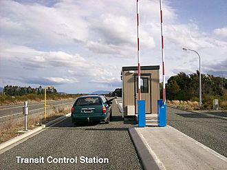
Avalanches are a common danger in the high mountains above the Milford Road during winter. Snow and ice also affect the road surface. Signs along the road tell drivers about the conditions. There's also a Transit New Zealand checkpoint. This ensures that drivers carry snow chains when needed for safe travel to Milford Sound.
Metal gates can close the Milford Road in the Hollyford and Cleddau Valleys. This happens when there's a high chance of avalanches. The road is closed about 8 days a year on average, mostly in winter. But snow can fall on the higher parts of the road at any time of year. Because of the nature of Fiordland, the road can close at any time due to landslides, fallen trees, or washouts. Always be careful, especially in the hillier areas between Mossburn and Milford Sound. Flooding can also happen at any time, especially near rivers.
Books About the Milford Road
Building the Milford Road section of SH 94 is a famous story. It's about the dangers, hard work, and cleverness of New Zealanders during the Great Depression. Several books have been written about it:
- Harold Anderson's 1975 book, Men of the Milford Road, tells the story from his view as a paymaster.
- Wilson Campbell's 2000 novel, When stars were brightly shining, is a fictional story about a murder in one of the work camps.
- John Hall-Jones's book, Milford Sound An Illustrated History of the Sound, the Track and the Road, shares detailed history and old photos of the road.
- Amy McDonalds' 2005 book, Below the Mountains, is a young girl's diary about living on the Milford Road from 1935 to 1936.
There are also books about mountain climbing in this area. These include Jack Ede's 1988 book, "Mountain Men of Milford," and Anita Crozier's 1950 book, Beyond the Southern Lakes.
Main Road Connections
| Territorial authority | Location | km | jct | Destinations | Notes |
|---|---|---|---|---|---|
| Gore District | Gore | 0 | SH 94 begins | ||
| Southland District | Lumsden | 61 | SH 94/SH 6 concurrency begins | ||
| 64 | SH 94/SH 6 concurrency ends | ||||
| Oreti River | |||||
| Mossburn | 80 | ||||
| The Key | 124 | (Hillside Manapouri Road) – Manapouri | |||
| Te Anau | 138 | ||||
| Fiordland National Park | 238 | Homer Tunnel 1,270 m (4,170 ft) length |
|||
| Milford Sound | 256 | SH 94 ends |
 | Delilah Pierce |
 | Gordon Parks |
 | Augusta Savage |
 | Charles Ethan Porter |


