Grey River / Māwheranui facts for kids
Quick facts for kids Grey River / Māwheranui |
|
|---|---|

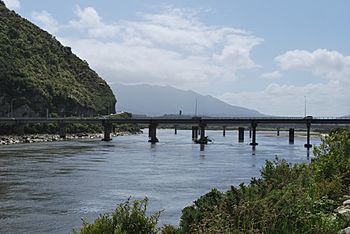
Cobden Bridge over the Grey River near its mouth at Greymouth
|
|

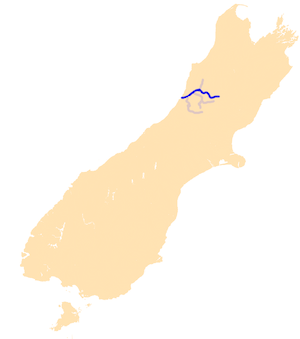
The Grey River system
|
|
| Native name | Māwheranui |
| Country | New Zealand |
| Region | Tasman, West Coast |
| Cities | Stillwater, Cobden, Greymouth |
| Physical characteristics | |
| Main source | Southern Alps (Saint Arnaud Range) Lake Christabel, New Zealand |
| River mouth | Tasman Sea New Zealand 0 m (0 ft) |
The Grey River / Māwheranui is an important river located on the northwest side of the South Island in New Zealand. It starts high up in the Southern Alps and flows for about 120 kilometers (75 miles) before reaching the Tasman Sea at a town called Greymouth. This river is a significant feature of the West Coast area.
Contents
Where the River Starts and Ends
The Grey River begins in Lake Christabel, which is one of many small lakes found on the western slopes of the Southern Alps. This area is about 12 kilometers (7.5 miles) southwest of the Lewis Pass. From there, the river travels west, collecting water from many smaller streams and rivers along its path. Finally, it empties into the Tasman Sea at the town of Greymouth, which is named after the river's mouth.
Naming the River
The river has two official names: Grey River and Māwheranui. The name "Grey River" was given by Thomas Brunner, an explorer who explored the area in the late 1840s. He named it after Sir George Grey, who was the Governor of New Zealand from 1845 to 1854.
The Māori name for the river is Māwheranui. The word Māwhera refers to the entire river system and the surrounding area. Māwheranui helps to tell it apart from a smaller northern branch called the Little Grey River / Māwheraiti. The New Zealand Ministry for Culture and Heritage explains that Māwheranui means "broad and widespread (river mouth)."
Other Rivers Joining In
Many smaller rivers and streams flow into the Grey River, making it bigger as it travels. Some of these smaller rivers also drain water from lakes. Two important rivers that join the Grey are the Ahaura River and the Arnold River. The Arnold River is especially notable because it flows out of Lake Brunner, which is the largest lake in the northwest part of the South Island. There is also a small hydroelectric power station on the river, about 25 kilometers (15.5 miles) upstream from its mouth. This station uses the river's water to create electricity.
Challenges and Solutions
The mouth of the Grey River at Greymouth has a large sandbar called the Greymouth bar. This sandbar can be quite dangerous for ships trying to enter or leave the river, making navigation tricky.
In the past, wastewater from the towns of Greymouth, Cobden, and Blaketown was released directly into the Grey River without being treated. However, the Grey District Council has made changes to improve their wastewater systems. Now, sewage is separated and treated before being released. During very heavy rainfall, like in springtime, the amount of water can sometimes be too much for the treatment system to handle. When this happens, some untreated water might still go into the river, but efforts are ongoing to reduce this impact and protect the river's health.
See also
 In Spanish: Río Grey (Nueva Zelanda) para niños
 | Tommie Smith |
 | Simone Manuel |
 | Shani Davis |
 | Simone Biles |
 | Alice Coachman |

