Cobden, New Zealand facts for kids
Quick facts for kids Cobden |
|
|---|---|
 |
|
| Basic information | |
| Local authority | Greymouth |
| Electoral ward | Central |
| Land area | 368 ha (1.42 sq mi)* |
| Population | 1,620 (June 2023) |
|
|
||
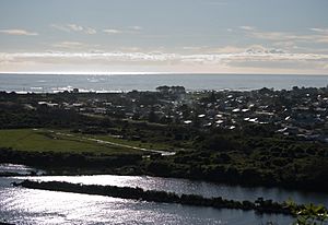
Cobden is a suburb located just north of Greymouth on the West Coast of New Zealand. The Grey River acts as a natural border, separating Cobden from the main part of Greymouth. North of Cobden, you'll find the Rapahoe Range, also known as the Twelve Apostles Range. A main road, State Highway 6, runs along the south-eastern side of Cobden.
For many years, from 1853 to 1876, Cobden was managed as part of the Nelson Province.
Contents
History of Cobden
Early Explorers and Settlements
Long ago, an explorer named Arthur Dudley Dobson saw Māori people living on the north side of the Grey River. They had a good-sized Pa (a fortified village) near where the Cobden quarry is today. There were also some huts, which were the remains of a much larger village.
In 1827, a French sailor named Jules Dumont d'Urville sailed along the West Coast of the South Island. He noticed the tall, pyramid-shaped limestone rocks at the bottom of the Rapahoe Range. These rocks are still known as the 'Twelve Apostles'.
Later, in 1846, Thomas Brunner and Charles Heaphy traveled from Nelson to explore the West Coast. They were very tired when they reached a place called Twelve Mile, just north of Rapahoe. Luckily, they met friendly Māori who gave them food and shelter. A group of Māori then guided them along the beach and past 'Matangitawau Point' (now Point Elizabeth). They continued to the Māwhera River, which was later named the Grey River. They couldn't cross the river for several days because it was flooded. Even though they didn't give a very good report about the area when they returned to Nelson, people soon became interested in the small settlement on the north side of the river.
How Cobden Got Its Name
After James Mackay finished buying the West Coast land from the Māori Chiefs in 1860, he needed to go back to Nelson. Even though the Grey River was a bit flooded, he and his friends tried to cross to the north bank by canoe. This was so they could continue their journey north. However, their canoe flipped over and was swept out to sea. Luckily, the group managed to reach the north bank safely. A few days later, their canoe washed up on the north beach.
The Grey River became the southern border for the Nelson Provincial Government. The leader at the time, Alfred Saunders, decided it was time to see the area's potential for himself. First, he sent two officials, John Blackett and H.W. Barnicoat, by sea to check out the area. But then Saunders himself set off overland with his own group. Both groups arrived at the Grey River around the same time. After looking around and checking on the people already living there, Superintendent Saunders decided the place needed a name. Saunders was very interested in English politics. He chose the name 'Cobden' to honor Richard Cobden, a famous English politician.
The Cobden Bridge Story
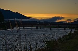
From the 1860s to the 1880s, the only ways to cross the Grey River were by boat or a public ferry. The ferry's schedule changed depending on the river's water level and the tides. This made crossing the river difficult and sometimes dangerous. In June 1883, a public meeting was held in Greymouth. People decided it was time to build a bridge to finally end 20 years of tricky river crossings.
Building the First Bridge
In February 1884, companies were asked to submit bids to build the bridge. The lowest bid, £15,000, came from Mr. J. M. Watson of Dunedin and was accepted. The bridge was designed to be made of kauri timber. It had six sections, each 109 feet long. It rested on five pairs of cast iron cylinders. These cylinders were 53 feet long and were 6 feet wide at the top, widening to 8 feet at the bottom. They were filled with concrete to make them strong.
The kauri timber was cut in forests north of Auckland. It was then shipped from Kaipara by a large sailing ship and brought across the Grey River bar. The heavy cast iron cylinders were sunk into the riverbed using a special method. Air was pumped into the cylinders, allowing workers to dig inside them in a dry space.
The bridge construction faced serious problems in 1885. Two big floods damaged and destroyed the last two cylinders on the Cobden side. However, the bridge was finally finished and opened in February 1886. The total cost of the bridge was £18,000. Local authorities paid £4,500 of this amount.
The Second Bridge
By 1916, the kauri timber parts of the bridge were starting to wear out. In March 1916, a new contract was given to Mr. H. Bignall of Greymouth. He was to replace the old timber with Australian hardwood for £14,320. This new construction was finished in 1920. The updated bridge even had a walkway wide enough for two baby strollers to pass each other!
The New Bridge Today
By 1960, the Road Safety Council asked for a new bridge. This was because the old one caused long delays for cars. By 1965, about 4,000 vehicles crossed the bridge every day. This number was expected to double in the next 10 years.
Construction on the newest bridge began in October 1973. To build the foundations, a temporary road of gravel was built across the river. Then, large steel cylinders were sunk into it to lower the water level. This allowed long steel H-shaped piles, up to 85 feet long, to be driven down to the solid limestone underneath. In the main part of the river, where the limestone is very deep (up to 160 feet below the riverbed), three piers were built. These piers were supported by 66-foot-long concrete piles. Fifty-five large concrete beams, each weighing 25 tons, were made locally. These were then lifted by crane to connect the piers. The bridge also included special hydraulic shock absorbers. These help the bridge withstand earthquakes.
During construction, two major floods caused some serious delays. The temporary gravel road was mainly damaged. Once completed, the bridge was 910 feet long with 11 sections. The total cost was $1.22 million. It was officially opened on Saturday, August 9, 1975. The opening ceremony was led by the Hon. Michael Aynsley Connelly, who was the Minister of Works and Development.
Population and People
Cobden covers an area of about 3.68 square kilometers. As of 2023, it has an estimated population of 1,620 people. This means there are about 440 people living in each square kilometer.
In the 2018 New Zealand census, Cobden had 1,551 residents. This was a small decrease from previous years. There were 666 households. The population included 771 males and 783 females. The average age was 40.5 years. About 19.3% of the people were under 15 years old.
Most people in Cobden (89.7%) are of European or Pākehā background. There are also people who identify as Māori (15.5%), Pasifika (1.9%), Asian (2.1%), and other ethnicities. Some people identify with more than one ethnic group. About 8.1% of the people in Cobden were born overseas.
When asked about their religion, 58.8% of people said they had no religion. About 27.5% were Christian. Smaller numbers followed Māori religious beliefs, Hindu, Muslim, Buddhist, or other religions.
Education
Cobden School is a school for both boys and girls. It teaches students from Year 1 to Year 8. As of February 2024. , the school has 84 students.
 | Jewel Prestage |
 | Ella Baker |
 | Fannie Lou Hamer |


