
Lake Brunner facts for kids
Quick facts for kids Lake Brunner |
|
|---|---|

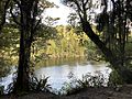
Fishing on Lake Brunner
|
|

Lake Brunner
Location in New Zealand
|
|
| Location | Grey District, West Coast region, South Island |
| Coordinates | 42°37′S 171°27′E / 42.617°S 171.450°E |
| Primary outflows | Arnold River |
| Basin countries | New Zealand |
| Surface area | 40 km2 (15 sq mi) |
| Max. depth | 109 m (358 ft) |
| Settlements | Moana |
Lake Brunner is the biggest lake in the northwest part of New Zealand's South Island. It covers a huge area of 40 square kilometers! Water flows out of Lake Brunner into the Arnold River. This river then joins the Grey River.
The lake is about 31 kilometers southeast of a town called Greymouth. The main town right by the lake is Moana, located on its northern side.
Even though it's a bit inland from the main coastal road (State Highway 6), Lake Brunner is becoming more and more popular. Many people visit it, especially because it's known as a great place for fishing.
What's in a Name?
Lake Brunner was named by John Rochfort after an explorer from the 1800s, Thomas Brunner. The Māori name for the lake is Kotuku moana. This beautiful name means "Sea of herons."
Amazing Lake Life
Lake Brunner is home to some interesting creatures. One of them is the New Zealand freshwater mussel. This mussel is also known as Hyridella menziesi. It lives in the lake's waters.
Keeping the Water Clean
The water quality of Lake Brunner has been checked regularly since the 1990s. These checks show that the water quality in the lake is slowly getting worse.
By 2010, most things measured for water quality were showing a decline. However, the lake was still thought to have good water quality overall. The area with the lowest water quality is Cashmere Bay, which is close to the town of Moana.
The local government, the West Coast Regional Council, has a plan to help. Their goal is to make sure the water quality stays good or even gets better.
Gallery


Images for kids
-
Rakaitane Walk beside the Arnold River

