Grey District facts for kids
Quick facts for kids
Grey District
|
|
|---|---|
|
Territorial authority district
|
|
 |
|
 |
|
| Country | New Zealand |
| Region | West Coast Regional Council |
| Wards |
|
| Seat | Greymouth |
| Area | |
| • Total | 3,474.44 km2 (1,341.49 sq mi) |
| Population
(June 2023)
|
|
| • Total | 14,250 |
| • Density | 4.1014/km2 (10.623/sq mi) |
| Time zone | UTC+12 (NZST) |
| • Summer (DST) | UTC+13 (NZDT) |
| Postcode(s) |
Map of postcodes
|
| Area code(s) | 03 |
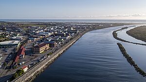
Grey District is a special area, or district, located in the West Coast Region of New Zealand. It includes the towns of Greymouth, Runanga, Blackball, Cobden, and other small places along the Grey River.
This district covers a land area of about 3,474 square kilometers. The main town and the place where the local government, the Grey District Council, is based is Greymouth. A large part of the district's population lives in Greymouth.
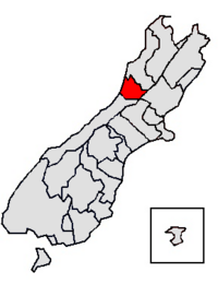
The Grey District is found on the west side of New Zealand's South Island. It stretches from the Punakaiki River in the north down to the Taramakau River in the south. The district reaches from the mountains to the Tasman Sea.
This area has a rich past and a unique feel. Important industries here include tourism, mining, farming, fishing, and making things. The main hospital for the entire West Coast region is also located in Greymouth.
People and Population
Grey District is about 3,474 square kilometers in size. In 2023, about 14,043 people lived here. This means there are about 4 people living in each square kilometer.
| Historical population | ||
|---|---|---|
| Year | Pop. | ±% p.a. |
| 2006 | 13,221 | — |
| 2013 | 13,371 | +0.16% |
| 2018 | 13,344 | −0.04% |
| 2023 | 14,043 | +1.03% |
| Ethnicity | Population |
|---|---|
| New Zealand European |
12,744
|
| Māori |
1,662
|
| Pasifika |
192
|
| Asian |
564
|
| MELAA |
66
|
| Other |
294
|
The population of Grey District grew by 5.2% between 2018 and 2023. The average age of people living here is 44.9 years old. About 18% of the people are under 15 years old. Also, about 21% are 65 years or older.
Most people in Grey District are of European background (90.7%). About 11.8% are Māori, and smaller numbers are from Pacific Islands or Asia.
In 2018, 10.1% of the people living in Grey District were born outside of New Zealand. This is less than the national average for New Zealand.
When asked about their beliefs, many people (51.7%) said they had no religion. About 36.9% were Christian. A small number followed other religions like Hinduism, Islam, or Buddhism.
District History

The first buildings near the Grey River mouth were built by the Ngati Wairangi Māori people in a place called Cobden. Later, European settlers arrived after they found coal and gold in the area.
Greymouth, the biggest town in the district, is located by the Tasman Sea and the Grey River. When gold was discovered, many new people moved to Greymouth. This changed the culture of the region quickly. People came for the gold rush, mining jobs, and other business chances.
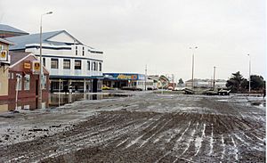
As Greymouth grew, it often suffered from floods. After two very big floods in 1988, a special flood wall was built. This wall was finished in 1990. It helps keep the town safe from floods and has allowed businesses to grow more.
A Māori settlement called Māwhera pā had been on the south bank of the Māwheranui river for a long time. In 1846, the first European explorers, Thomas Brunner and Charles Heaphy, visited. They stayed at the pā and were given food. Two years later, Brunner explored the river and renamed it after Governor George Grey.
In 1860, a man named James Mackay talked with the local Māori chiefs. They agreed for the government to buy the West Coast region. This agreement was signed at Māwhera pā on May 21, 1860. The land around the pā was kept as a special Māori reserve. Today, this area is the main business part of Greymouth, and much of it is still owned by Māori.
Roads and Transport
The Grey District has a network of roads. There are 619 kilometers of roads in total. About 358 kilometers of these roads are sealed, meaning they have a smooth, paved surface.
See also
 In Spanish: Distrito de Grey para niños
 | Janet Taylor Pickett |
 | Synthia Saint James |
 | Howardena Pindell |
 | Faith Ringgold |

