Hooker Valley Track facts for kids
Quick facts for kids Hooker Valley Track |
|
|---|---|
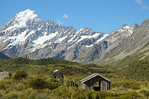
Typical view from along the track - an old shelter at Stocking Stream, in front of Aoraki / Mount Cook
|
|
| Length | 5 km (3.1 mi) |
| Location | Aoraki/Mount Cook National Park, New Zealand |
| Designation | Walking track |
| Trailheads | White Horse Hill camping ground, Hooker Lake |
| Use | Tramping |
| Highest point | Hooker Lake 877 m (2,877 ft) |
| Lowest point | 760 m (2,490 ft) |
| Difficulty | Easy |
| Season | All year |
| Sights | Wide glacier valleys with tussock vegetation, glaciers and glacier lakes, moraine ridges, clear views of Aoraki / Mount Cook and other snow-covered peaks (weather permitting) |
| Hazards | Sunburn |
| Surface | Fine gravel, well-formed |
| Website | Department of Conservation |
The Hooker Valley Track is a super popular walking path in Aoraki/Mount Cook National Park in New Zealand. It's about 5 kilometres (3.1 mi) long and only goes up about 100 metres (330 ft), so it's easy for almost everyone to walk.
The Department of Conservation takes care of the track. Along the way, you'll see amazing views of Aoraki / Mount Cook, New Zealand's tallest mountain. The path also leads to Hooker Lake, a special lake often filled with floating icebergs! Many people say the Hooker Valley Track is one of the 'best day walks in New Zealand'.
The end of the track offers the closest views you can get of Aoraki / Mount Cook without climbing. You'll see the huge Hooker Glacier down in the valley. You can even walk right down to the lake's edge. The area around the track is open and grassy, with low-growing plants called tussocks. This means you get clear, wide-open views of the snowy mountains all around you.
Contents
Starting Your Adventure: The Track's Beginning
The Hooker Valley Track begins at the White Horse Hill camping ground. You can get there from Mount Cook Village by driving about 4 kilometres (2.5 mi) on a paved road. Or, you can walk a similar distance from Mount Cook Village to the camping ground. This walking path starts near The Hermitage Hotel.
At the camping ground, you'll find a car park, toilets, and a big, modern shelter. This shelter has cool information boards about the area. Sometimes in winter, heavy snow can close the road to White Horse Hill. But you can still walk from Mount Cook Village to the track's start. The path from The Hermitage Hotel is usually open too.
Memorial and First Bridge Views
The very start of the Hooker Valley Track goes through open grassy fields. You'll pass close to the Alpine Memorial. This is a special place to remember climbers who have sadly passed away in Mount Cook National Park. From here, you can also see the lake formed by the Mueller Glacier.
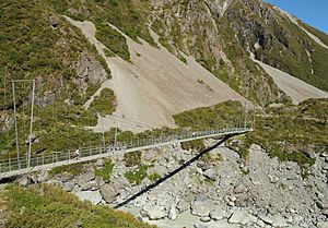
Soon after the memorial, you'll cross the Hooker River on the first of three strong wooden suspension bridges. These bridges were updated in 2015. The track then goes around a natural wall of rock and dirt, called a moraine wall. This wall holds back the Mueller Glacier lake.
You'll cross the Hooker River again, this time above the Mueller Glacier lake. After this second bridge, the track continues north into the wide Hooker Valley. As you walk, you'll get clearer and clearer views of Aoraki / Mount Cook. This amazing mountain stays in sight for the whole second half of your walk!
Plants and Scenery Along the Way
The plants along this part of the track change. You'll see snow tussock, spiky spear grass, large mountain daisies, and the beautiful Mount Cook Lily. All these alpine plants bloom with flowers during the summer months, from December to February.
Sometimes, the track gets very close to the Hooker River. The river water is a light bluish-grey color. This is because of tiny rock particles, called rock flour, that are suspended in the melting glacier water. When you reach Stocking Stream, you'll cross it on a small footbridge. Here, you'll see the concrete base of an old hut that used to be there. There are also two self-composting toilets, which are the only toilets along the Hooker Valley Track.
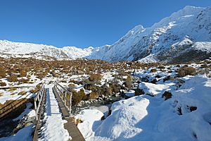
North of Stocking Stream, the wide, flat valley floor can get a bit swampy. So, the track continues on a wooden boardwalk to keep your feet dry. After this, you'll reach the last of the suspension bridges.
Reaching Hooker Lake: Icebergs and Views
The track crosses the Hooker River for a third time, just below the moraine walls of Hooker Lake. A short side path leads off the main track to a small pond. Then, the main track goes around the moraine wall, gently climbing up.
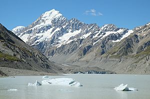
You'll reach a lookout point with picnic tables, offering amazing views over the glacial Hooker Lake. From the lookout, a small path goes down to the lake's shore. In the summer, you can often see cool icebergs floating in the lake! The lookout also gives you a great view across the lake to the end of the Hooker Glacier.
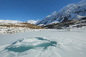
In winter, the track can have snow and ice. The lake often freezes over completely. The walking track isn't cleared of snow, but it's mostly flat and not near dangerous avalanche areas. So, it's usually safe for people with average fitness. The wooden steps near the memorial can get slippery after frosty nights. You can walk through the snow next to the steps to avoid them.
In the coldest parts of winter, if the ice on Hooker Lake is thick enough, it can even be safe to walk on it. But you must be very careful! Icebergs that were already in the lake before it froze will be stuck in place. The slight movement of these icebergs can break the ice around them, so you should avoid those areas.
Important Tips for Your Walk
The Hooker Valley Track is very open, so there's no shade from the strong sunlight. It's a good idea to wear sunscreen to protect your skin. There are no boat tours on Hooker Lake, unlike at the nearby Tasman Lake.
You don't need a special permit or have to pay a fee to walk the Hooker Valley Track. Also, please remember that dogs and bicycles are not allowed on the track.
 | Kyle Baker |
 | Joseph Yoakum |
 | Laura Wheeler Waring |
 | Henry Ossawa Tanner |


