
Mount Cook Village facts for kids
Quick facts for kids
Mount Cook Village
|
|
|---|---|
|
Town
|
|
| Aoraki / Mount Cook | |

Mount Cook Village down below in Hooker Valley, The Hermitage on the left, lodge and motel complex on the bottom right
|
|
| Country | New Zealand |
| Island | South Island |
| Region | Canterbury |
| Territorial Authority | Mackenzie District |
| Ward | Pukaki Ward |
| Community | Twizel Community |
| Electorates |
|
| Area | |
| • Total | 4.26 km2 (1.64 sq mi) |
| Elevation | 750 m (2,460 ft) |
| Population
(June 2023)
|
|
| • Total | 200 |
| • Density | 47/km2 (122/sq mi) |
Mount Cook Village, officially known as Aoraki / Mount Cook, is a special place in New Zealand. It's located right inside the Aoraki / Mount Cook National Park. This village is only about 15 kilometers (9 miles) south of Aoraki / Mount Cook, New Zealand's highest mountain, which is part of the Southern Alps.
Because the village is inside a National Park, people can't actually own land or property here. However, since the hotels and motels are open all year, about 250 people live in the village permanently.
All the buildings and services in the village operate with special permission from the government. You won't find big grocery stores here, just a small convenience shop inside the hotel. The closest large supermarket is about 65 kilometers (40 miles) away in Twizel. There's also a self-service petrol pump, but fuel can be expensive because the village is so remote.
Mount Cook Village even has a small school, sometimes with as few as a dozen students! It's the only school in New Zealand that is located inside a national park.
Contents
History of Mount Cook Village
The very first building in the area that became Mount Cook Village was the second Hermitage hotel. It was built in 1913 and opened its doors in 1914. Sadly, this hotel burned down completely in 1957. A new hotel was built in its place in 1958, which is now part of the current hotel complex.
The 1960s and 1970s were a time of big growth for the hotel and Mount Cook Village. Important things like water pipes, sewage treatment, local streets, and paved roads (State Highway 80) were added. These improvements made it much easier to get to the village. A local fire brigade was also started in 1976 to help keep everyone safe.
The official name of the village was changed to a dual name, Aoraki / Mount Cook, in 1998. This change was part of the Ngāi Tahu Claims Settlement Act 1998, which recognized the importance of Māori names.
Who Lives in Mount Cook Village?
Statistics New Zealand describes Mount Cook Village as a rural settlement. It covers about 4.26 square kilometers (1.64 sq mi). In 2018, the village had an estimated population of 213 people. This means there were about 50 people living in each square kilometer.
Before 2023, the village area was larger, covering 9.68 square kilometers (3.74 sq mi). In the 2018 New Zealand census, 213 people lived here. This was a small increase from 2013 and 2006. Most people living here were from Europe (53.5%), but there were also people from Asia (25.4%), Pasifika (8.5%), and Māori (2.8%).
Exploring Mount Cook Village: Tourism and Activities
Mount Cook Village is a popular spot, welcoming around 250,000 visitors every year. It has many different places to stay and things to do.
The main hotel in the village is called The Hermitage. This name goes all the way back to the very first hotel built in 1884. The Hermitage is a very popular place, especially for visitors from other countries. Sometimes, people even use "The Hermitage" as another name for the whole village. The hotel also has smaller chalets, a lodge, and motel rooms, offering options from backpacker beds to family units.
There are two other motels in the village, and a total of four restaurants or pubs. Two of these are located inside the main Hermitage hotel. Paved paths connect all the buildings and motel units, making it easy to walk around.
If you like camping, there's a small camping ground called White Horse Hill about 2 kilometers (1.2 miles) outside the village. You can reach it by a walking track.
Many companies offer exciting activities from the village. You can go on guided walks, 4WD safaris, or even take a boat trip on the Tasman glacier lake. Other adventures include horse treks, fishing, and scenic flights that even land on the glaciers! These tours usually start and end at the main entrance of The Hermitage hotel.
Mount Cook Village is also a great starting point for many walks and climbs. There are short, easy walks through the forest right in the village. For longer adventures, you can try the popular Hooker Valley Track or more challenging climbs like the steep path to Sealy Tarns.
The village is home to the national park's visitor center. It's also where climbers, hunters, and trampers begin their journeys to the many huts in the area.
Climate in Mount Cook Village
Mount Cook Village has an oceanic climate, which means it has mild summers with cool nights. Winters are chilly, and temperatures often drop below freezing at night. It rains a lot throughout the year.
| Climate data for Mount Cook Village, elevation 730 m (2,400 ft), (1991–2020 normals, extremes 1929-present) | |||||||||||||
|---|---|---|---|---|---|---|---|---|---|---|---|---|---|
| Month | Jan | Feb | Mar | Apr | May | Jun | Jul | Aug | Sep | Oct | Nov | Dec | Year |
| Record high °C (°F) | 32.8 (91.0) |
32.4 (90.3) |
29.9 (85.8) |
24.4 (75.9) |
23.2 (73.8) |
19.0 (66.2) |
18.3 (64.9) |
22.1 (71.8) |
25.0 (77.0) |
25.7 (78.3) |
28.6 (83.5) |
30.1 (86.2) |
32.8 (91.0) |
| Mean maximum °C (°F) | 28 (82) |
27.6 (81.7) |
25.5 (77.9) |
21.9 (71.4) |
18.1 (64.6) |
14.8 (58.6) |
14.0 (57.2) |
15.6 (60.1) |
19.0 (66.2) |
21.9 (71.4) |
24.4 (75.9) |
26 (79) |
29.7 (85.5) |
| Mean daily maximum °C (°F) | 20.4 (68.7) |
20.8 (69.4) |
18.4 (65.1) |
14.9 (58.8) |
11.0 (51.8) |
7.9 (46.2) |
7.2 (45.0) |
9.1 (48.4) |
11.8 (53.2) |
14.0 (57.2) |
16.3 (61.3) |
18.5 (65.3) |
14.2 (57.6) |
| Daily mean °C (°F) | 14.6 (58.3) |
14.7 (58.5) |
12.4 (54.3) |
9.4 (48.9) |
6.2 (43.2) |
3.2 (37.8) |
2.5 (36.5) |
4.1 (39.4) |
6.6 (43.9) |
8.6 (47.5) |
10.6 (51.1) |
12.8 (55.0) |
8.8 (47.8) |
| Mean daily minimum °C (°F) | 8.7 (47.7) |
8.5 (47.3) |
6.5 (43.7) |
4.0 (39.2) |
1.3 (34.3) |
−1.4 (29.5) |
−2.2 (28.0) |
−0.8 (30.6) |
1.5 (34.7) |
3.1 (37.6) |
5.0 (41.0) |
7.0 (44.6) |
3.4 (38.1) |
| Mean minimum °C (°F) | 2 (36) |
2.1 (35.8) |
0.4 (32.7) |
−1.5 (29.3) |
−3.7 (25.3) |
−6.8 (19.8) |
−7.2 (19.0) |
−5.8 (21.6) |
−4.0 (24.8) |
−2.7 (27.1) |
−1.1 (30.0) |
1.2 (34.2) |
−8.3 (17.1) |
| Record low °C (°F) | −8.3 (17.1) |
−4.4 (24.1) |
−7.2 (19.0) |
−7.8 (18.0) |
−13.3 (8.1) |
−13.9 (7.0) |
−16.9 (1.6) |
−12.8 (9.0) |
−15.0 (5.0) |
−10.0 (14.0) |
−12.2 (10.0) |
−10.6 (12.9) |
−16.9 (1.6) |
| Average rainfall mm (inches) | 418.7 (16.48) |
272.0 (10.71) |
315.0 (12.40) |
336.5 (13.25) |
377.8 (14.87) |
291.0 (11.46) |
288.6 (11.36) |
283.8 (11.17) |
361.0 (14.21) |
394.4 (15.53) |
367.6 (14.47) |
425.9 (16.77) |
4,132.3 (162.68) |
| Average rainy days (≥ 1.0 mm) | 11.3 | 9.0 | 10.0 | 11.5 | 15.2 | 14.2 | 13.2 | 13.6 | 15.0 | 15.8 | 13.5 | 13.8 | 156.1 |
| Average relative humidity (%) | 64.7 | 69.8 | 73.7 | 76.1 | 81.4 | 82.0 | 79.0 | 79.4 | 67.5 | 66.3 | 64.1 | 66.7 | 72.6 |
| Mean monthly sunshine hours | 183.5 | 172.3 | 157.5 | 123.8 | 86.0 | 73.4 | 80.0 | 112.8 | 121.1 | 152.1 | 165.8 | 178.9 | 1,607.2 |
| Source: NIWA Climate Data | |||||||||||||
| Climate data for Mt Cook Airport, elevation 656 m (2,152 ft), (2012-2024 normals, extremes 2012-present) | |||||||||||||
|---|---|---|---|---|---|---|---|---|---|---|---|---|---|
| Month | Jan | Feb | Mar | Apr | May | Jun | Jul | Aug | Sep | Oct | Nov | Dec | Year |
| Record high °C (°F) | 33.5 (92.3) |
30.5 (86.9) |
27.2 (81.0) |
23.7 (74.7) |
20.3 (68.5) |
17.9 (64.2) |
16.0 (60.8) |
17.7 (63.9) |
22.3 (72.1) |
26.1 (79.0) |
28.5 (83.3) |
29.3 (84.7) |
33.5 (92.3) |
| Mean maximum °C (°F) | 29.2 (84.6) |
28.0 (82.4) |
25.6 (78.1) |
22.2 (72.0) |
18.9 (66.0) |
14.9 (58.8) |
14.3 (57.7) |
15.3 (59.5) |
18.9 (66.0) |
22.7 (72.9) |
24.8 (76.6) |
27.0 (80.6) |
30.2 (86.4) |
| Mean daily maximum °C (°F) | 22.0 (71.6) |
21.7 (71.1) |
19.3 (66.7) |
15.1 (59.2) |
11.9 (53.4) |
8.3 (46.9) |
7.9 (46.2) |
9.6 (49.3) |
12.2 (54.0) |
14.9 (58.8) |
17.1 (62.8) |
19.8 (67.6) |
15.0 (59.0) |
| Daily mean °C (°F) | 15.5 (59.9) |
15.2 (59.4) |
12.9 (55.2) |
9.5 (49.1) |
6.5 (43.7) |
3.2 (37.8) |
2.8 (37.0) |
4.3 (39.7) |
6.6 (43.9) |
9.2 (48.6) |
11.3 (52.3) |
13.9 (57.0) |
9.2 (48.6) |
| Mean daily minimum °C (°F) | 9.1 (48.4) |
8.7 (47.7) |
6.6 (43.9) |
3.9 (39.0) |
1.2 (34.2) |
−1.8 (28.8) |
−2.4 (27.7) |
−0.9 (30.4) |
1.0 (33.8) |
3.5 (38.3) |
5.6 (42.1) |
8.1 (46.6) |
3.6 (38.4) |
| Mean minimum °C (°F) | 1.2 (34.2) |
1.8 (35.2) |
0.0 (32.0) |
−2.6 (27.3) |
−6.0 (21.2) |
−8.7 (16.3) |
−9.8 (14.4) |
−8.6 (16.5) |
−6.9 (19.6) |
−4.4 (24.1) |
−1.5 (29.3) |
0.8 (33.4) |
−11.6 (11.1) |
| Record low °C (°F) | −1.9 (28.6) |
−0.2 (31.6) |
−2.0 (28.4) |
−4.5 (23.9) |
−8.8 (16.2) |
−15.0 (5.0) |
−13.7 (7.3) |
−14.1 (6.6) |
−9.6 (14.7) |
−7.5 (18.5) |
−3.7 (25.3) |
−1.7 (28.9) |
−15.0 (5.0) |
| Average rainfall mm (inches) | 235.7 (9.28) |
136.8 (5.39) |
152.6 (6.01) |
191.8 (7.55) |
233.7 (9.20) |
227.5 (8.96) |
235.0 (9.25) |
191.1 (7.52) |
224.7 (8.85) |
223.8 (8.81) |
190.3 (7.49) |
197.1 (7.76) |
2,440.1 (96.07) |
| Source: NIWA | |||||||||||||
| Climate data for Mueller Hut, elevation 1,818 m (5,965 ft), (1991–2020) | |||||||||||||
|---|---|---|---|---|---|---|---|---|---|---|---|---|---|
| Month | Jan | Feb | Mar | Apr | May | Jun | Jul | Aug | Sep | Oct | Nov | Dec | Year |
| Mean daily maximum °C (°F) | 10.9 (51.6) |
11.8 (53.2) |
10.3 (50.5) |
7.3 (45.1) |
4.9 (40.8) |
3.7 (38.7) |
2.0 (35.6) |
2.8 (37.0) |
3.8 (38.8) |
4.7 (40.5) |
7.2 (45.0) |
9.3 (48.7) |
6.6 (43.8) |
| Daily mean °C (°F) | 7.4 (45.3) |
8.3 (46.9) |
6.9 (44.4) |
3.9 (39.0) |
1.9 (35.4) |
0.2 (32.4) |
−1.2 (29.8) |
−0.8 (30.6) |
0.1 (32.2) |
1.3 (34.3) |
3.5 (38.3) |
5.6 (42.1) |
3.1 (37.6) |
| Mean daily minimum °C (°F) | 3.8 (38.8) |
4.9 (40.8) |
3.5 (38.3) |
0.6 (33.1) |
−1.1 (30.0) |
−3.2 (26.2) |
−4.4 (24.1) |
−4.3 (24.3) |
−3.5 (25.7) |
−2.0 (28.4) |
−0.3 (31.5) |
2.0 (35.6) |
−0.3 (31.4) |
| Source: NIWA | |||||||||||||
Education in Aoraki Mount Cook
Aoraki Mount Cook School is a primary school that teaches students from year 1 to year 8. As of 2024, it has 12 students. The school first opened in 1960.
Images for kids
-
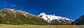
Panorama of Hooker valley with Mount Cook Village on left in front of the Sealy Range, and Mount Sefton and The Footstool in the center of the frame
