
National parks of New Zealand facts for kids


New Zealand's national parks are special natural places. The Department of Conservation (DOC) looks after them. At first, the parks were mostly about mountains. But since the 1980s, they have included many different types of New Zealand landscapes. These parks are important for their culture and history too. Tongariro National Park is a World Heritage Site because it's important for both its nature and culture. Four parks in the South Island together form Te Wahipounamu, which is another World Heritage Site.
Today, New Zealand has 13 national parks. There used to be 14, but Te Urewera National Park became a different kind of protected area in 2014. The Department of Conservation manages these parks so everyone can enjoy them. Many tourists from other countries visit at least one national park when they come to New Zealand.
Contents
Laws for National Parks
The National Parks Act of 1980 is a law that explains what national parks are for. It also says how they should be managed and chosen. The law says that national parks are places that are kept forever. They are important because of their beautiful scenery, unique plants and animals, or special natural features. Protecting these areas is good for the whole country.
Everyone can visit national parks. However, there are some rules to follow. These rules help protect the native plants and animals. They also keep the parks safe and healthy. Some very special areas, about 550 square kilometers, need a permit to enter.
What You Can Do in Parks
The National Parks Act says that the Department of Conservation can build things like huts, campgrounds, and walking tracks. They can also provide parking areas and roads. The department also offers some places to stay and transport near the park entrances. Other groups and businesses also offer services like guided walks or skiing lessons inside the parks. They need special permission from the department to do this.
Important Court Decision in 2018
In 2018, a Māori tribe called Ngāi Tai ki Tāmaki won a case in the Supreme Court. This decision meant they could ask the Department of Conservation for special rights. These rights would allow them to run businesses on Motutapu and Rangitoto islands. The court's decision was based on the Treaty of Waitangi. It recognized that Ngāi Tai ki Tāmaki traditionally owned these islands, even though the Department of Conservation manages them. This decision affected how the Department of Conservation plans for all protected areas, including national parks. Because of this, reviews of plans for Aoraki / Mount Cook National Park and Westland Tai Poutini National Park were paused.
List of National Parks
This table shows all the current and former national parks in New Zealand. They are listed in alphabetical order. * Green shading and asterisk – Parks that are part of a World Heritage Site
| National Park | Image | Area | Established | Location | Number of DOC huts | Description | |
|---|---|---|---|---|---|---|---|
| km2 | sq mi | ||||||
| Abel Tasman National Park |  |
237 | 92 | 1942 | 40°50′S 172°54′E / 40.833°S 172.900°E | 7 | This is the smallest national park. It has many golden sand beaches and tidal inlets along Tasman Bay. Many people enjoy hiking or kayaking here. |
| Aoraki / Mount Cook National Park* |  |
722 | 279 | 1953 | 43°44′S 170°6′E / 43.733°S 170.100°E | 16 | This park is in the alpine mountains. It has New Zealand's highest mountain, Aoraki / Mount Cook (3,724 m). It also has the longest glacier, Haupapa / Tasman Glacier (29 km). It's a great place for mountaineering and scenic flights. |
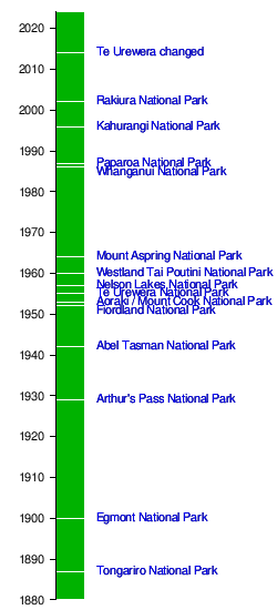
| Arthur's Pass National Park |  |
1,185 | 458 | 1929 | 42°57′S 171°34′E / 42.950°S 171.567°E | 28 | This is a rough and mountainous area. It crosses the main ridge of the Southern Alps. |
| Egmont National Park |  |
342 | 132 | 1900 | 39°16′S 174°6′E / 39.267°S 174.100°E | 8 | This park covers the land around Mount Taranaki. The mountain is a dormant volcano with a perfect cone shape. It's a famous landmark in the area. |
| Fiordland National Park* |  |
12,607 | 4,868 | 1952 | 45°25′S 167°43′E / 45.417°S 167.717°E | 51 | This is the largest national park in New Zealand. It's one of the biggest in the world. It covers the southwest part of the South Island. Its deep fiords, glacial lakes, mountains, and waterfalls make it a popular place to visit. |
| Kahurangi National Park |  |
4,529 | 1,749 | 1996 | 41°15′S 172°7′E / 41.250°S 172.117°E | 51 | This park is in the northwest of the South Island. It has amazing and wild country, including the popular Heaphy Track. Old landforms and unique plants and animals make this New Zealand's second largest national park very special. |
| Mount Aspiring National Park* |  |
3,562 | 1,375 | 1964 | 44°23′S 168°44′E / 44.383°S 168.733°E | 19 | This park has many mountains shaped by glaciers. It is centered around Mount Aspiring / Tititea (3,033 metres (9,951 ft)). This is New Zealand's highest peak outside of Aoraki/Mt Cook National Park. |
| Nelson Lakes National Park |  |
1,019 | 393 | 1956 | 41°49′9″S 172°50′15″E / 41.81917°S 172.83750°E | 20 | This is a rugged, mountainous area south of Nelson. It stretches from the forested shores of Lakes Rotoiti and Rotoroa to the Lewis Pass National Reserve. |
| Paparoa National Park | .jpg) |
430 | 170 | 1987 | 42°5′S 171°30′E / 42.083°S 171.500°E | 2 | This park is on the West Coast of the South Island. It is located between Westport and Greymouth. It includes the famous Pancake Rocks at Punakaiki. |
| Rakiura National Park |  |
1,400 | 540 | 2002 | 46°54′S 168°7′E / 46.900°S 168.117°E | 24 | This is the newest national park. It covers about 85% of Stewart Island / Rakiura. |
| Te Urewera National Park (disestablished 2014) |  |
2,127 | 821 | 1954 | 38°45′S 177°9′E / 38.750°S 177.150°E | 29 | Te Urewera and the nearby Whirinaki Te Pua-a-Tāne Conservation Park have the largest native forest in the North Island. Lake Waikaremoana is known for its beautiful shoreline. Since 2014, it's still a protected area. However, it's no longer a national park. It's now managed under a special agreement between the government and the Tūhoe iwi (Māori tribe). |
| Tongariro National Park* |  |
786 | 303 | 1887 | 39°12′S 175°35′E / 39.200°S 175.583°E | 10 | This was New Zealand's first national park. It's a World Heritage Site because of its amazing nature and cultural importance. Te Heuheu Tūkino IV gave the land to the Crown. The park has several sacred Māori sites and three active volcanoes: Ruapehu, Ngauruhoe, and Tongariro. |
| Westland Tai Poutini National Park* |  |
1,320 | 510 | 1960 | 43°23′S 170°11′E / 43.383°S 170.183°E | 12 | This park stretches from the highest peaks of the Southern Alps to a wild coastline. It includes glaciers, beautiful lakes, and thick rainforest. You can also find remains of old gold mining towns along the coast. |
| Whanganui National Park |  |
742 | 286 | 1986 | 39°35′S 175°5′E / 39.583°S 175.083°E | 5 | This park borders the Whanganui River. It includes areas of government land, old state forests, and several former reserves. |
Timeline of National Parks
Future National Parks
There are ideas for new national parks. One idea is for a Kauri National Park around Waipoua Forest. This area has most of New Zealand's remaining kauri trees, including the giant Tāne Mahuta. These kauri forests are also safe homes for endangered animals like the North Island brown kiwi. The Department of Conservation is currently looking into this idea.
In 2014, a group called Forest and Bird started a campaign. They want Great Barrier Island (Aotea) to become a National Park. This was in response to a proposal from the Department of Conservation to give the island more protection.
In 2020, a political party announced that they would create two new national parks if they won the election. These would be Coromandel National Park and Catlins National Park.
Protecting Parks from Mining
In 2010, the New Zealand Government suggested allowing mining in some national park and conservation areas. These areas were protected by a law that stopped mining. However, many people disagreed with this idea. They sent in a lot of comments, mostly saying no to mining. Because of this, the government decided not to go ahead with the plan.
