
Lake Waikaremoana facts for kids
Quick facts for kids Lake Waikaremoana |
|
|---|---|
.JPG)
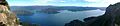
Lake Waikaremoana (winter 2015)
|
|

Lake Waikaremoana
Location in North Island
|
|

Location
|
|
| Location | Wairoa District, Hawke's Bay Region, North Island |
| Coordinates | 38°46′S 177°05′E / 38.767°S 177.083°E |
| Primary outflows | Waikaretaheke River |
| Basin countries | New Zealand |
| Surface area | 54 km2 (21 sq mi) |
| Max. depth | 256 m (840 ft) |
| Shore length1 | 102.3 km (63.6 mi) |
| Surface elevation | 600 m (2,000 ft) |
| Settlements | Āniwaniwa |
| 1 Shore length is not a well-defined measure. | |
Lake Waikaremoana is a beautiful lake found in Te Urewera on the North Island of New Zealand. It's about 60 kilometres (37 miles) northwest of Wairoa. The lake is quite large, covering an area of 54 square kilometres (21 square miles). Its name comes from the Māori language and means 'sea of rippling waters'.
This lake is in the heart of the Tuhoe people's traditional lands. You can find the small village of Aniwaniwa and the Waikaremoana Holiday Park right on the lake's edge. They are located along State Highway 38. This road connects the lake to other parts of the North Island, like Rotorua and Gisborne.
There is a Department of Conservation office in Aniwaniwa. Many walking trails start here, including a short walk to the lovely Aniwaniwa Falls. Another village, Onepoto, is on the southern side of the lake. Its name means 'short beach', because of a small bay with a beach only 60 metres (200 feet) long.
Lake Waikaremoana is a popular spot for holidays. People come here to fish, hike, and enjoy other outdoor activities. The Lake Waikaremoana Track is one of New Zealand's famous "Great Walks". This hike takes about three to four days and goes around half of the lake. You can walk it on your own or with a guided group. There are huts along the track where you can stay, but you need to book them in advance. Camping is also allowed, as long as you are not too close to the track.
The weather around the lake is mild in summer and cool in winter. It sometimes snows a few times a year. Not too many tourists visit the area because the road to get there is mostly unsealed (not paved). This means Lake Waikaremoana is often quieter than other Great Walks in New Zealand. A smaller lake called Lake Waikareiti is just four kilometres (2.5 miles) to the northeast.
Contents
Lake Waikaremoana: Deepest Lake and Unique Formation
Lake Waikaremoana is the deepest lake on New Zealand's North Island. It is 256 metres (840 feet) deep! The surface of the lake is 600 metres (1,969 feet) above sea level. This amazing lake was formed about 2,200 years ago by a huge landslide dam. A massive landslide, about 250 metres (820 feet) high, blocked a river and created the lake behind it.
Other interesting natural features around the lake include Panekiri Bluff and Puketukutuku Peninsula. The peninsula is a special place where they work to protect the native kiwi birds. The lake is surrounded by mountains covered in native forest that has never been cut down. Many native bird species that are rare elsewhere in the North Island live here. There's also a programme to hunt possums to help protect the forest and its plants.
The weather at Lake Waikaremoana can change quickly. Hikers need to be careful and watch out for sudden changes in conditions. Heavy rains can happen, especially in late winter and early spring.
Hydroelectric Power from a Natural Dam
.JPG)
The Waikaremoana Hydroelectric Power Scheme is quite special. It's one of the only power stations built on a natural landslide dam. This means it uses the water held back by the ancient landslide to create electricity.
How the Dam Was Made Stronger
Engineers have carefully studied the natural dam to make sure it is strong and safe. In the 1930s and 1940s, they built tunnels through the landslide to control the water flow. This was a difficult job because they had to deal with water leaking into the tunnels.
After the tunnels were finished, they sealed the lake's side of the natural dam. They removed wood from under the water and then added many layers of crushed rock and clay. This helped to stop water from leaking out naturally. This sealing work greatly reduced the amount of water that used to flow out of the lake through the landslide.
Power Stations and Electricity
The Waikaretaheke River carries water from Lake Waikaremoana. This water flows through three power stations: Kaitawa, Tuai, and Piripaua. These stations use the water's drop in height, which is about 450 metres (1,476 feet), to generate electricity. Together, they can produce up to 138 megawatts of power. The Kaitawa station uses a 250-metre (820-foot) drop in water, which is one of the highest for a dam in New Zealand and even in the world!
Images for kids
-
View of Lake Waikaremoana from Panekiri Bluff
See also
 In Spanish: Lago Waikaremoana para niños
