
Wairoa facts for kids
Quick facts for kids
Wairoa
|
|
|---|---|
|
Minor urban area
|
|

Riverbank adjacent to town centre, viewed from the bridge over the Wairoa River, 2010
|
|
| Country | New Zealand |
| Region | Hawke's Bay |
| Territorial authority | Wairoa District |
| Electorates |
|
| Area | |
| • Total | 7.57 km2 (2.92 sq mi) |
| Population
(June 2023)
|
|
| • Total | 5,020 |
| • Density | 663.1/km2 (1,717.5/sq mi) |
| Postcode(s) |
4108
|
| Website | Official website: http://www.wairoadc.govt.nz/ |
Wairoa is a town in the Hawke's Bay region of New Zealand. It is the biggest town in the Wairoa District. Wairoa is located on the northern shore of Hawke Bay. It sits where the Wairoa River meets the sea.
The town is about 118 kilometers northeast of Napier. It is also 92 kilometers southwest of Gisborne. You can reach Wairoa by State Highway 2. It is also the closest town to the Te Urewera protected area. This area used to be a national park. Wairoa is special because many Māori live here. About 62% of the people in Wairoa identify as Māori.
Contents
History of Wairoa
Early Beginnings
Wairoa was first a Māori settlement. An old canoe, called Tākitimu, traveled up the Wairoa River. It landed near where the Tākitimu meeting house is today. The river was very important for travel and trading. It was also a key source of food. People still fish for whitebait, flounder, and eels there.

Europeans started settling here in 1839. William Rhodes set up a station for whaling and trading. They mainly traded flax. Wairoa was first called Clyde. But its name was changed to avoid confusion with other towns. The northern part of the town is still called North Clyde. Wairoa became important during the New Zealand Wars. It was a place where soldiers were stationed.
The New Zealand government bought the land for the town in 1864. This land was then sold in smaller pieces in 1866. The Wairoa Harbour Board was created in 1872. The Wairoa lighthouse was built between 1877 and 1878. Its light first shone in 1878. The first bridge over the Wairoa River was built in 1888.
Events in the 1900s
The Wairoa Borough Council was set up in 1909. Building a railway line from Napier to Wairoa started in 1911. The railway bridge over the Wairoa River was finished in 1930. The whole railway line was completed in 1937. In 1938, heavy floods damaged the railway line. Workers repaired it, and trains were running again by 1939. This meant fewer ships used the port at Wairoa. The port closed in 1942. The Wairoa Harbour Board was then closed in 1946. The road bridge was damaged in the 1931 Hawke's Bay earthquake. A new road bridge was finished in 1933.
In 1988, a big storm called Cyclone Bola hit the North Island. Wairoa had three days of heavy rain. This caused severe flooding and damage. A 60-meter part of the town's main bridge was lost. This cut the town in half. Phone lines and water supply were also affected. Farms, businesses, and homes were badly flooded. A new bridge, the third one in that spot, was opened in 1990 by Queen Elizabeth II.
In 1990, Wairoa won the last New Zealand Top Town Final. This was in the original Top Town TV series. They were the champions until the show started again in 2009.
Wairoa in the 2000s
In 2017, Rocket Lab built a rocket launch site. It is on the Mahia Peninsula. Wairoa is the closest town to this site. This has created many job opportunities for people in Wairoa.
Some banks in Wairoa have closed. The ANZ bank closed in 2018. The BNZ and Westpac banks closed in 2021. Wairoa also lost its only dentist in 2020. Now, people have to travel to Gisborne or Napier for dental care.
In February 2023, Cyclone Gabrielle hit Wairoa. It was described as the worst weather event in memory. State Highway 2 between Napier and Wairoa was closed until May 2023. This was due to the damage. In May 2023, plans began to stop future flooding. The Hawke's Bay Regional Council wants to invest in a flood protection plan. The mayor, Craig Little, said Wairoa currently has "zero flood protection".
In June 2024, Wairoa had very heavy rain and high tides. This caused 118 homes to flood. A blockage at the mouth of the Wairoa River made the flooding worse. The river burst its banks, flooding areas three blocks inland. The New Zealand Government gave NZ$3 million to help with disaster relief. Both the Hawke's Bay Regional Council and the Government are looking into ways to prevent future floods.
People of Wairoa
Wairoa covers about 7.57 square kilometers. In 2023, its estimated population was around 5,170 people. This means there are about 683 people per square kilometer.
In 2018, Wairoa had 4,527 people. This was an increase from 2013. There were 1,548 homes. The population included 2,223 males and 2,304 females. The average age was 36.4 years old. About 24.7% of people were under 15 years old.
The people of Wairoa come from different backgrounds. About 43.0% were European/Pākehā. A large part, 69.5%, were Māori. There were also Pacific peoples (4.4%) and Asian people (3.5%). Some people identify with more than one group.
About 8.3% of people were born outside New Zealand. Many people (34.7%) said they had no religion. About 39.4% were Christian. Also, 14.6% followed Māori religious beliefs.
For those aged 15 and older, 8.4% had a university degree or higher. About 29.4% had no formal qualifications. The average income was $21,500. About 39.3% of people worked full-time. Another 13.5% worked part-time.
Wairoa's Weather
| Climate data for Wairoa (1991–2020 normals, extremes 1950–present) | |||||||||||||
|---|---|---|---|---|---|---|---|---|---|---|---|---|---|
| Month | Jan | Feb | Mar | Apr | May | Jun | Jul | Aug | Sep | Oct | Nov | Dec | Year |
| Record high °C (°F) | 38.0 (100.4) |
37.3 (99.1) |
33.0 (91.4) |
30.6 (87.1) |
26.7 (80.1) |
24.7 (76.5) |
23.3 (73.9) |
24.3 (75.7) |
29.6 (85.3) |
31.2 (88.2) |
34.1 (93.4) |
34.5 (94.1) |
38.0 (100.4) |
| Mean maximum °C (°F) | 32.2 (90.0) |
31.3 (88.3) |
28.9 (84.0) |
25.8 (78.4) |
23.3 (73.9) |
20.0 (68.0) |
19.0 (66.2) |
19.9 (67.8) |
22.8 (73.0) |
25.7 (78.3) |
27.9 (82.2) |
29.6 (85.3) |
33.1 (91.6) |
| Mean daily maximum °C (°F) | 25.1 (77.2) |
24.5 (76.1) |
22.6 (72.7) |
19.9 (67.8) |
17.7 (63.9) |
15.2 (59.4) |
14.2 (57.6) |
15.1 (59.2) |
17.1 (62.8) |
19.4 (66.9) |
21.2 (70.2) |
23.4 (74.1) |
19.6 (67.3) |
| Daily mean °C (°F) | 19.4 (66.9) |
19.3 (66.7) |
17.4 (63.3) |
14.9 (58.8) |
12.5 (54.5) |
10.2 (50.4) |
9.5 (49.1) |
10.2 (50.4) |
12.0 (53.6) |
14.0 (57.2) |
15.8 (60.4) |
18.2 (64.8) |
14.5 (58.0) |
| Mean daily minimum °C (°F) | 13.8 (56.8) |
14.0 (57.2) |
12.2 (54.0) |
9.9 (49.8) |
7.4 (45.3) |
5.2 (41.4) |
4.8 (40.6) |
5.2 (41.4) |
6.8 (44.2) |
8.6 (47.5) |
10.5 (50.9) |
12.9 (55.2) |
9.3 (48.7) |
| Mean minimum °C (°F) | 7.9 (46.2) |
8.4 (47.1) |
7.0 (44.6) |
4.3 (39.7) |
1.8 (35.2) |
0.2 (32.4) |
0.0 (32.0) |
0.4 (32.7) |
1.5 (34.7) |
2.9 (37.2) |
4.6 (40.3) |
7.2 (45.0) |
−0.4 (31.3) |
| Record low °C (°F) | 4.7 (40.5) |
4.5 (40.1) |
3.5 (38.3) |
0.6 (33.1) |
−0.9 (30.4) |
−2.5 (27.5) |
−2.3 (27.9) |
−1.6 (29.1) |
−0.8 (30.6) |
0.1 (32.2) |
−0.2 (31.6) |
3.1 (37.6) |
−2.5 (27.5) |
| Average rainfall mm (inches) | 87.3 (3.44) |
87.7 (3.45) |
102.6 (4.04) |
130.7 (5.15) |
98.5 (3.88) |
124.5 (4.90) |
123.2 (4.85) |
92.1 (3.63) |
87.9 (3.46) |
93.1 (3.67) |
80.7 (3.18) |
77.1 (3.04) |
1,185.4 (46.69) |
| Source: NIWA | |||||||||||||
Wairoa's Economy
Wairoa has a meat processing plant. It started in 1916. The company AFFCO bought it in 1990. This plant employs about 650 people during its busiest time. They process sheep, lamb, goat, and beef. Much of their product is sent overseas. There is also a plant that makes bone meal and tallow from animal parts.
Growing forests is becoming more important for Wairoa's economy. Many farms are being turned into forests. These forests help earn carbon credits. Some people worry that losing farms might make the town's economy smaller. This could also lead to fewer people living in the town.
In 2020, the government gave $6.1 million to help rebuild the town center. This money will help create a business and tourism center. It will also support digital job programs and a digital hub.
Things to Do and See in Wairoa
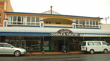
Since 2005, Wairoa has hosted the annual Wairoa Māori Film Festival. This is New Zealand's main Māori and indigenous film festival. Filmmakers from New Zealand and around the world come to this event. Since 2015, parts of the festival have been held at the Gaiety Cinema and Theatre. This cinema has a very advanced sound system.
The Wairoa Agricultural & Pastoral Society started in 1899. They hold an annual show with many events. These include rodeo, dog trials, sheep shearing, and horse jumping. The 2022 show was canceled because of Covid-19 rules.
The Wairoa museum is at 142 Marine Parade. Since 2001, it has been in the old ANZ bank building. The museum shows local and Māori history. It has a Māori flag from the Māori land wars in 1865. In 2016, the museum made its exhibition space bigger. It also updated its galleries and added a new "discovery space" for visitors.
The Wairoa Centennial Library was built in 1960. The Wairoa Rotary Club raised money to add an extension in 1974. This extension was to house a museum. More work was done on the library in 1988 and 2003. The library is at 212 Marine Parade.
Wairoa has two golf courses. The Wairoa Golf Club is 5 kilometers north of the town center. The Mahia Golf Club is on the Mahia Peninsula. It has a nine-hole course.
The Wairoa community center has an indoor stadium. You can play indoor soccer, netball, cricket, badminton, volleyball, and basketball there. It also has a gym and a 25-meter indoor swimming pool. It is located at 33 Marine Parade.
Marae in Wairoa
The town has several marae (meeting grounds) and wharenui (meeting houses). These are for the local iwi (tribe) of Ngāti Kahungunu. They are also for its hapū (sub-tribes).
| Marae | Wharenui | Affiliated hapū |
|---|---|---|
| Hinemihi | Te Poho o Hinemihi | Ngāti Hinemihi |
| Hurumua | Hurumua Memorial Hall | Ngāi Tānemitirangi |
| Iwitea | Te Poho o Tahu | Mātawhaiti |
| Kihitu | Te Rauhina | Ngāti Kahu |
| Ruataniwha | Te Poho o Riria | Ngāi Te Kapuamātotoru |
| Taihoa | Te Otane | Ngāti Kurupakiaka and Te Kāwiti |
| Tākitimu-Waihirere | Tākitimu Wharenui | Ngāi Te Apatu and Ngāti Moewhare |
| Tawhiti A Maru | St Therese's Church | Catholic church |
| Te Mira, Whetū Mārama and Mill Pā | Mākoro | Ngāti Mākoro |
| Whaakirangi | Whaakirangi | Ngāti Mātangirau |
| Arimawha | Te Poho o Hinetu, Ko Amiria | Ngāti Hinetu |
| Rangiāhua | Te Poho o Tama te Rangi | Ngai Tama Te Rangi |
| Pākōwhai | Te Huinga o te Aroha | Ngāti Mihi |
In October 2020, the government gave $1,949,075 to upgrade many marae. This included Ruataniwha, Hinemihi, Hurumua, and others. This project also created 164 jobs.
Wairoa's Infrastructure
Water Services
In 2020, the Wairoa District Council asked for permission for its wastewater system. Wastewater is released into an estuary in the Wairoa River. An independent review said that releasing wastewater into the river is not good for the community's culture. However, they noted that treating wastewater on land is too expensive right now. The council was urged to get help from the government.
In 2021, the government talked about big changes for water services across New Zealand. This would involve moving water assets from local councils to four new large groups. The mayor of Wairoa, Craig Little, was concerned about these changes. He worried about losing local control over water services.
Wairoa Hospital
Wairoa Hospital is called Te Hauora o te Wairoa / Wairoa Health. It has 12 beds for maternity and medical patients. The Hawke's Bay District Health Board runs it. The hospital also has a general doctor's office. It has an emergency department, X-ray services, and lab services. Mental health and addiction services are also available. It is located at 36 Kitchener Street, Wairoa.
Getting Around Wairoa
The Wairoa airport is on Airport Road. Its runway is 914 meters long. The Wairoa Aero Club is based at this airport.
Wairoa is connected to Napier by State Highway 2. This highway also goes northeast to Gisborne. State Highway 38 connects Wairoa to the northwest. It passes Lake Waikaremoana and joins State Highway 5.
The railway line from Napier to Gisborne was closed in 2012. It was damaged by a storm. It was repaired and reopened between Napier and Wairoa in 2020. This was thanks to $6.2 million in funding. Freight trains carried logs to Napier Port. The service stopped briefly due to COVID-19. It reopened in November 2020.
Important Buildings
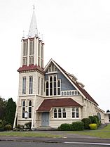
St Andrew's Church (Presbyterian-Methodist) is at 98 Queen Street. It is a historic place. It was likely built between 1932 and 1935.
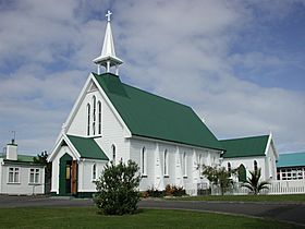
St Peter's Catholic Church is at 64 Queen Street. It is also a historic place. It is one of Wairoa's oldest buildings. It was finished in 1882. It is made of timber and shows New Zealand Gothic Revival church style.
The Wairoa Meat Company building is on Marine Parade. It is a historic place. Built between 1915 and 1920, it shows Wairoa's long history with meat processing. It survived the 1931 Napier earthquake. In 2020, it received money to make it stronger against earthquakes.
The Wairoa County Chambers building is on Queen Street. It is a historic place.
The Gaiety Cinema and Theatre is at 252 Marine Parade. It was built in 1925. It was destroyed in the 1931 Hawkes Bay earthquake. It was rebuilt in 1932 in an Art Deco style. It has hosted movies, concerts, and other events. It closed in 1960 and was used for other things. In 1998, work began to restore it as a cinema and theatre. It reopened in 2000. It closed again in 2009 due to money issues. It reopened in 2015 with help from the Wairoa District Council. It can hold 250 people.
- Notable buildings
-
St Andrew's Church
-
St Peter's Church
-
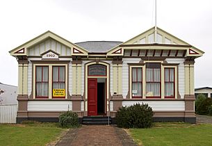
Wairoa County Chambers (1902)
-
Gaiety Cinema and Theatre


Schools in Wairoa
- Wairoa College is a high school for students aged 11-18. It is a state school for both boys and girls.
- Wairoa Primary School is a state primary school for students aged 5-10. It is for both boys and girls.
- Tiaho Primary School is a state primary school for students aged 5-10. It is for both boys and girls.
- TKKM o Ngati Kahungunu o Te Wairoa is a Māori immersion school. Students aged 5-18 learn mostly in Māori here. It is for both boys and girls.
- St Joseph's School is a Catholic primary school. It is a state-integrated school for students aged 5-12. It is for both boys and girls.
Famous People from Wairoa
- Ethan Browne, actor
- Bronwyn Elsmore, writer and religious studies lecturer
- Derek Fox, broadcaster and former mayor of Wairoa
- Pana Hema Taylor, actor
- Katarina Kawana, musician
- Esme Tombleson, politician
- Mere Whaanga, author and historian
