
Wairoa River (Hawke's Bay) facts for kids
Quick facts for kids Wairoa River |
|
|---|---|
.png)
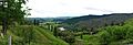
Hawke's Bay's Wairoa River system
|
|
| Country | New Zealand |
| Physical characteristics | |
| Main source | Te Reinga Falls |
| River mouth | Hawke Bay |
| Length | 65 km (40 mi) |
The Wairoa River is a river in the Hawke's Bay area of New Zealand. It flows for 65 kilometres (about 40 miles) from the eastern part of the North Island. The river starts west of Gisborne and then flows south. It finally empties into northern Hawke Bay at the town of Wairoa.
The full Māori name for the river is Te Wairoa Hōpūpū Hōnengenenge Mātangi Rau. This long name means "the long, bubbling, swirling, uneven waters."
Contents
What is the Wairoa River?
The Wairoa River is an important waterway in New Zealand. It is 65 kilometres (40 miles) long. The river's water comes from a large area called a catchment area. This area covers about 3,660 square kilometres (1,415 square miles). This huge area includes Lake Waikaremoana, a well-known lake.
Where Does the Wairoa River Start?
The Wairoa River begins where two other rivers meet. These are the Hangaroa River and the Ruakituri River. They join together at a place called Te Reinga Falls, near the town of Te Reinga. This is the official start of the Wairoa River.
Main Rivers that Feed the Wairoa
Many smaller rivers flow into the Wairoa River, bringing it water. These are called tributaries. The main tributaries include:
- the Hangaroa River
- the Ruakituri River
- the Mangapoike River
- the Mangaaruhe River
- the Waiau River
- the Waikaretaheke River
Lake Waikaremoana is a special lake that feeds the Wairoa River. It was formed when a rockfall blocked the Waikaretaheke River. The Waikaretaheke River later joins the Waiau River, about 14 miles (22 kilometres) from the coast.
Major Flooding Events
Rivers can sometimes overflow their banks, causing floods. The Wairoa River has had some big floods in the past.
The Great Flood of 1948
In 1948, a very large flood happened on the Wairoa River. The water rose so high that it went over the traffic bridge in the town of Wairoa. Parts of the town were flooded with water up to 3 feet (about 1 metre) deep. This flood was one of the biggest ever recorded for any river in New Zealand.
Wairoa River Walkway Project
The Wairoa River is also a place for people to enjoy. In 2010, a project started to build a walkway along the river.
Exploring the River Walkway
This project is called the Wairoa Township River Walkway. It is a path for people to walk or cycle. The walkway starts on the south bank of the Wairoa River, near the main bridge. The plan is to eventually make the walkway go all the way around the town of Wairoa. This will give people a great way to explore the river and the town.
Images for kids
-
Wairoa River Valley between Te Reinga and Frasertown
