
Paparoa National Park facts for kids
Quick facts for kids Paparoa National Park |
|
|---|---|
|
IUCN Category II (National Park)
|
|

Paparoa National Park
Location in New Zealand
|
|
| Location | West Coast, New Zealand |
| Area | 429.7 km2 (165.9 sq mi) |
| Established | January 1, 1987 |
| Governing body | Department of Conservation |
Paparoa National Park is a special place on the west coast of the South Island of New Zealand. It was created in 1987 and covers about 430 square kilometers (166 square miles). The park stretches from the coast all the way up to the top of the Paparoa Mountains. There's also a separate part of the park further north, around Ananui Creek.

This park is famous for its limestone karst area, which means it has many caves. One of these, Metro Cave / Te Ananui Cave, is a popular place for visitors. Most of the park is covered in forests with many different kinds of plants. Sadly, the park was also the site of the 1995 Cave Creek disaster, where a viewing platform collapsed and fourteen people died.
The Paparoa Track, which is one of New Zealand's famous "Great Walks," goes right through the park. The small town of Punakaiki, known for its "Pancake Rocks," is right next to the park. Other nearby towns include Westport, Greymouth, and Barrytown.
Contents
How the Park Was Created
People started thinking about protecting the Paparoa Ranges a long time ago. In 1976, a group called the Federated Mountain Clubs of New Zealand thought the northern part of the mountains would be a great wilderness area. Later, in 1979, the Native Forest Action Council suggested creating a huge national park.
This idea led to the government looking into making the western Paparoa Range a national park. Other environmental groups, like the Royal Forest and Bird Protection Society of New Zealand, also helped. After many discussions and proposals, Paparoa National Park was officially opened on November 23, 1987. It started with an area of about 30,327 hectares.
Amazing Landforms
Paparoa National Park has a mix of different landscapes. You can find mountains, lowlands, and coastal areas all in one park!
Mountains
More than half of the park is mountainous. These mountains have steep cliffs and deep valleys. The rocks in the Paparoa mountains are very old, mostly granite and gneiss. These rocks are actually similar to those found far away in Fiordland. This is because a huge crack in the Earth's crust, called the Alpine Fault, has slowly moved them apart over millions of years.
Karst Caves and Rivers

One of the most exciting features of the park is its karst landscape. This means that as rivers flow from the Paparoa Mountains, they pass through soft limestone rock. Over time, the water carves out amazing underground rivers and huge cave systems. The main rivers here are the Fox, Pororari, and Punakaiki. Cave Creek, where the 1995 accident happened, is another one of these rivers.
The rivers often flow through narrow, deep gorges with high, forest-covered limestone cliffs. You might also see dry streambeds, holes where water disappears into the ground (called sinkholes), and places where water suddenly comes out of a cave. All these signs show that there's a complex network of tunnels and caverns hidden beneath the surface. Water slowly creates these caves by dissolving the limestone. The forests help this process by adding natural acids to the water from decaying plants.
Coastal Region


The coastline of Paparoa National Park is very dramatic. It has tall cliffs shaped by the waves of the Tasman Sea, along with small coves and sandy beaches. You can also see small islands and tall rock pillars just off the shore. These areas were once islands but became part of the mainland when New Zealand's land was pushed up by geological forces.
The most famous part of the coast is the "Pancake Rocks" at Dolomite Point, near Punakaiki. Here, you can see layers of limestone that look like stacks of pancakes. The waves have carved out holes and blowholes in these rocks, creating amazing water displays when the tide is right.
Wildlife of the Park
The park is home to many different animals, especially birds. You can find birds living from the coastline all the way up to the mountain peaks. Some birds, like tui, bellbird, kaka, New Zealand pigeon, and parakeets, move between the lower forests in winter and the higher forests in summer.
A very special bird found here is the rare Westland petrel or tāiko. A large group of these seabirds lives on the forested terraces just south of the Punakaiki River. This breeding site is so important that it has been named an Important Bird Area by BirdLife International.
You can also see large groups of New Zealand fur seals in nearby areas like Cape Foulwind near Westport. Sometimes, rare southern elephant seals and leopard seals visit the coast. Hector's dolphins, which are some of the smallest and rarest dolphins, are often seen close to shore. Other dolphins, including killer whales, can also be spotted. While whale numbers are still small, different types of whales have been observed here.
Protecting the Park from Mining
Paparoa National Park is usually protected from mining by a special law called the Crown Minerals Act. However, there have been times when people wanted to allow some mining inside the park.
In 2010, the government suggested removing some land from this protection, which would have allowed mining in about 8% of the park. This idea caused a lot of discussion. Many people were worried about the park's future.
After receiving over 37,000 comments from the public, the government decided not to remove any land from the protected list. Instead, they even added more land to the protected areas, including a small part of Paparoa National Park. This showed how much people cared about keeping the park safe from mining.
Park Additions and Memorial Tracks
After a mining company called Pike River Coal closed down, the government bought the land around the Pike River Mine. In 2015, the environment minister announced that this land, about 3,580 hectares, would be added to Paparoa National Park.
A new 55-kilometer walking and biking trail, called the Paparoa Track, was built through the park. It goes from Blackball to Punakaiki. There's also a special path called the Pike29 Memorial Track. Both of these tracks were created to remember the 29 miners who tragically died in the 2010 Pike River Mine disaster.
Most of the miners' families supported the creation of these tracks. The Paparoa Track has also helped the West Coast become a popular place for adventure sports, like trail running and mountain biking. Events like "The Paparoa" celebrate the region's mining history and its amazing female athletes.
Images for kids
-
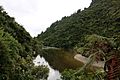
Pororari River Track
-
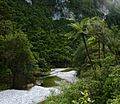
Fox River- Paparoa National Park
-
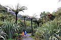
Paparoa Track (Pororari river)


See also
 In Spanish: Parque nacional de Paparoa para niños
