Barrytown facts for kids
Quick facts for kids
Barrytown
|
|
|---|---|

Barrytown Hall
|
|
| Country | New Zealand |
| Region | West Coast |
| District | Grey District |
| Ward | Northern |
| Electorates |
|
| Area | |
| • Total | 30.27 km2 (11.69 sq mi) |
| Population
(2018 Census)
|
|
| • Total | 186 |
| • Density | 6.145/km2 (15.91/sq mi) |
| Local iwi | Ngāi Tahu |
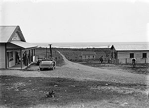
Barrytown is a small town in the West Coast of New Zealand's South Island. It's located on State Highway 6, about 21 kilometers (13 miles) north of Runanga. The town sits on an area called the Barrytown Flats, close to Pakiroa Beach. The Māori name for this area is Paparoa. Barrytown was once known as Seventeen Mile Beach and Fosbery.
Contents
History of Barrytown
Early Māori History
The land around Barrytown originally belonged to the Māori people. The local group, or hapū, is Ngāti Waewae, part of the iwi (tribe) Ngāi Tahu. Pakiroa Beach, along the Barrytown Flats, was a very important place for Māori to find food. Old shell piles, called middens, found here show that people lived and gathered food in this area as far back as 1500 AD. These middens are linked to the Waitaha iwi.
Gold Rush and Naming the Town
In the 1860s, a gold rush brought many miners to the area. They worked at Seventeen Mile Beach and Canoe Creek. By 1879, about 2,000 miners lived there. In 1880, the small town that served these miners was officially named "Fosbery." A post office opened there.
However, the next year, the government asked residents and miners to vote on a name. They could choose between Fosbery and Barrytown. All 130 votes were for Barrytown, so the town was renamed!
Life in Early Barrytown
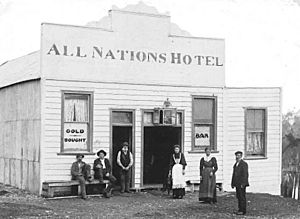
By 1895, Barrytown had grown. It had a Catholic church and a state school for children. There were also two places to stay (lodging-houses), a smithy (where metal was worked), and the All Nations Hotel. Two general stores, one with a butchery and bakery, had been open since the 1870s. Mail was sent out twice a week from the post office.
People of Barrytown
Barrytown is a small community. In 2018, about 186 people lived in the immediate Barrytown area. This was an increase from previous years, showing the community is growing.
| Historical population for Barrytown and surrounds | ||
|---|---|---|
| Year | Pop. | ±% p.a. |
| 2006 | 132 | — |
| 2013 | 156 | +2.42% |
| 2018 | 186 | +3.58% |
Most people living in Barrytown are of European descent. Some residents also identify as Māori, Pasifika, or Asian. The community has a mix of ages, with people of all generations living there.
Economy and Culture
Barrytown is known as a place where artists and craftspeople live and work. You can find people doing things like stone carving and making knives here.
All Nations Hotel
The Barrytown hotel was built in 1879. It had seven bedrooms and another building that could sleep 10 people. It was famous for its billiard room, which had a special Alcock billiard table. The hotel is still open today and is a popular spot.
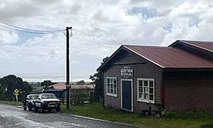
Barrytown Settlers Hall
The Barrytown Settlers Hall was built in 1929. It's a very famous place for music! Since 1972, it has hosted many concerts. Both international and local bands often play there when they tour New Zealand. Some famous groups that have performed include Blerta, Trinity Roots, The Mint Chicks, and Bad Manners. Sometimes, there are as many as 25 music events in a single year!
Barrytown Flats and Environment
The town is located near the end of a 17-kilometer (11-mile) flat coastal area called the Barrytown Flats. In the 1860s, people used special methods to search for gold in the sands here.
Today, some of the drier parts of the flats are used for farming. However, many important forest areas remain, like the Nikau Scenic Reserve. The flats are next to Paparoa National Park. This area is also the only place where the Westland petrel, a special type of seabird, breeds.
There are also large amounts of a mineral called ilmenite in the Barrytown sands. This mineral contains titanium dioxide. There have been ideas to mine it, but people worry about how this might affect the environment.
Education in Barrytown
The first school in Barrytown was built in the early 1880s. An inspector visited the town and found that 57 children were old enough for school. Because of this, a school was built, and a school committee was set up.
Today, Barrytown School is a coeducational primary school. It teaches students from Year 1 to Year 8. As of 2023, there were 28 students attending the school.
Climate
| Climate data for Barrytown (1981–2010) | |||||||||||||
|---|---|---|---|---|---|---|---|---|---|---|---|---|---|
| Month | Jan | Feb | Mar | Apr | May | Jun | Jul | Aug | Sep | Oct | Nov | Dec | Year |
| Mean daily maximum °C (°F) | 19.8 (67.6) |
20.4 (68.7) |
19.3 (66.7) |
17.1 (62.8) |
15.3 (59.5) |
13.4 (56.1) |
13.0 (55.4) |
13.4 (56.1) |
14.4 (57.9) |
15.4 (59.7) |
16.7 (62.1) |
18.6 (65.5) |
16.4 (61.5) |
| Daily mean °C (°F) | 16.4 (61.5) |
16.9 (62.4) |
15.8 (60.4) |
13.9 (57.0) |
12.2 (54.0) |
10.4 (50.7) |
9.8 (49.6) |
10.3 (50.5) |
11.3 (52.3) |
12.2 (54.0) |
13.4 (56.1) |
15.2 (59.4) |
13.2 (55.7) |
| Mean daily minimum °C (°F) | 12.9 (55.2) |
13.3 (55.9) |
12.3 (54.1) |
10.6 (51.1) |
9.2 (48.6) |
7.4 (45.3) |
6.6 (43.9) |
7.2 (45.0) |
8.2 (46.8) |
9.0 (48.2) |
10.1 (50.2) |
11.9 (53.4) |
9.9 (49.8) |
| Average rainfall mm (inches) | 246.3 (9.70) |
181.9 (7.16) |
200.4 (7.89) |
220.4 (8.68) |
255.5 (10.06) |
225.0 (8.86) |
223.5 (8.80) |
168.2 (6.62) |
228.3 (8.99) |
248.2 (9.77) |
243.7 (9.59) |
290.6 (11.44) |
2,732 (107.56) |
| Source: NIWA (rain 1971–2000) | |||||||||||||
 | Aaron Henry |
 | T. R. M. Howard |
 | Jesse Jackson |


