Lake Tekapo facts for kids
Quick facts for kids Lake Tekapo |
|
|---|---|
Lake Tekapo
|
|
| Lua error in Module:Location_map at line 420: attempt to index field 'wikibase' (a nil value). | |
| Location | Mackenzie District, Canterbury region, South Island |
| Native name | Takapō (Māori) |
| Primary inflows | Godley River (north), Macauley River (north), Mistake River (west), Cass River (west) |
| Primary outflows | Tekapo River |
| Catchment area | 1,463 km2 (565 sq mi) |
| Max. length | 27 km (17 mi) |
| Max. width | 6 km (3.7 mi) (max), 3.5 kilometres (2.2 mi) (mean) |
| Surface area | 87 km2 (34 sq mi) (summer), 82 km2 (32 sq mi) (winter), |
| Average depth | 69 m (226 ft) |
| Max. depth | 120 m (390 ft) |
| Water volume | 6 km3 (4.9×10⁶ acre⋅ft) |
| Surface elevation | 710 m (2,330 ft) |
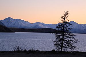
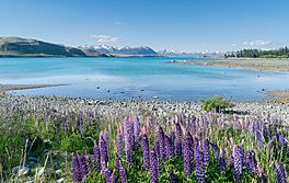
Lake Tekapo (Māori: Takapō) is a beautiful lake in the South Island of New Zealand. It's one of three large lakes in the Mackenzie Basin, along with Lake Pukaki and Lake Ōhau. This lake covers about 83 km2 (32 sq mi) and sits high up at 710 m (2,330 ft) above sea level. It's a popular spot for tourists and is known for its amazing turquoise water and clear night skies.
Contents
What's in a Name? The Story of Takapō
The name "Tekapo" is actually a slightly different spelling of Takapō, which is the lake's name in the Māori language. Takapō means "to leave in haste at night."
In 2021, the local council decided to use both names, Tekapo and Takapō, when talking about the lake. This helps honor the Māori heritage of the area.
Ancient Legends: How Takapō Was Formed
According to the Ngāi Tahu people, Lake Tekapo was created by a brave explorer named Rākaihautū. He used his special digging stick, called Tūwhakaroria, to dig out many of the freshwater lakes in the South Island.
Rākaihautū arrived in New Zealand on a large canoe called the Uruao waka. He then split his group into two. Rākaihautū led one group down the middle of the island, digging lakes as he went. His son, Rakihouia, led the other group along the east coast.
Motuariki Island: A Legend in Stone
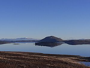
Motuariki is a small island in the middle of Lake Tekapo. The Ngāi Tahu people have a legend about this island. It tells of an ancestor named Motuariki, who was on the Āraiteuru waka. This canoe capsized near Shag Point.
Many passengers went ashore to explore, but they had to return to the waka before daylight. Motuariki didn't make it back in time. Because of this, he was turned into the island we see today.
Exploring Lake Tekapo's Geography
Lake Tekapo gets its water from the Godley River and Macaulay River in the north. These rivers flow from the Southern Alps. The water from melting glaciers carries tiny bits of rock, called glacial silt. This silt gives Lake Tekapo its special light turquoise color.
The lake is surrounded by mountains. To the east, you'll find the Two Thumb Range with peaks like Mount Toby. On the western side, there's Mount John, which is close to the town.
The water temperature on the lake's surface changes with the seasons. It's coldest in September, around 5.8 to 5.9 °C, and warmest in January, reaching about 17 °C.
Lake Tekapo is a popular place for visitors. There are hotels in the town of Lake Tekapo, which is at the southern end of the lake. You can also visit the Lake Tekapo Regional Park nearby. State Highway 8 runs right past the lake.
On a clear day, you can even see the tall, snow-capped mountains of Aoraki / Mount Cook National Park from Lake Tekapo. The area is also very sunny, with over 2,400 hours of sunshine each year!
Stargazing: A Dark-Sky Wonderland
Lake Tekapo and the area around it are part of the Aoraki Mackenzie International Dark-Sky Reserve. This special area was created in 2012. It's huge, covering 4,367 km2 (1,686 sq mi), making it the largest dark-sky reserve in the southern hemisphere as of 2024.
Being a dark-sky reserve means the night skies here are almost completely free of light pollution. This makes it a perfect place for astronomers, astrophotographers, and tourists who love to look at the stars. There's even an astronomical observatory on Mount John, just north of the town.
Beautiful Lupins
Lake Tekapo is famous for its stunning display of Lupin flowers. These colorful flowers bloom along the lake's shores from mid-November until the end of December.
Russell lupins were first brought to the Mackenzie Basin in the 1940s. A woman named Connie Scott scattered lupin seeds along the roadside in 1949. While these flowers are beautiful, they can also change the natural environment of the braided rivers. Sometimes, if the lake's water level is too high at a key time, fewer lupins might bloom.
Drivers are asked to be careful during lupin season. Many visitors slow down or stop to admire the flowers along State Highway 8, which can be dangerous if not done safely.
Power from the Lake: Hydroelectricity
Lake Tekapo plays an important role in making electricity for New Zealand. Originally, the lake's water flowed into the Tekapo River. But in 1938, work began on a power station. This station, now called Tekapo A, started making power in 1951.
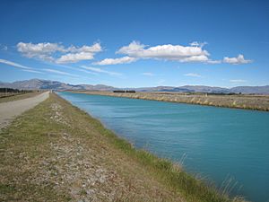
Water from the lake travels through a 1.4 km (4,600 ft) tunnel under the town to reach the power station. In the 1970s, a large hydroelectric project was built. Now, the water from Tekapo A flows into a 26 km (16 mi) canal. This canal carries the water to another power station, Tekapo B, which is located on the shores of Lake Pukaki.
These power stations help provide electricity to many homes. For example, the Tekapo A power station alone can power almost 100,000 homes! In 2021, Tekapo A was even upgraded to be stronger against earthquakes.
Fun on the Slopes: Roundhill Ski Area
On the north side of Lake Tekapo, about 24 km (15 mi) from the town, you'll find the Roundhill Ski Area. This ski field is great for beginners and intermediate skiers.
For more advanced skiers, Roundhill has the world's longest and steepest rope tow. This tow takes skiers to the top of the Richmond Range, at an elevation of 2,133 m (6,998 ft)!
Famous Buildings and Statues
The Church of the Good Shepherd
Right on the shores of Lake Tekapo stands the Church of the Good Shepherd. Built in 1935, it was the first church in the Mackenzie Basin.
The church was designed by an architect from Christchurch, based on ideas from a local artist. It's one of the most photographed churches in New Zealand. Its altar window offers amazing views of the lake and mountains.
The Bronze Sheepdog Statue
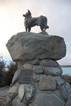
Near the Church of the Good Shepherd, you'll find a famous bronze statue of a New Zealand Collie sheepdog. The people who live in the Mackenzie Country had this statue made. It's a way to thank the sheepdogs for their incredibly important role in their lives.
The sculptor, Innes Elliott, used a neighbor's dog named Haig as his model. It took him about fifteen months to create the statue.
Fishing Adventures
Lake Tekapo is a fantastic place for fishing! You can catch large brown trout and rainbow trout here. One way to fish is by trolling a lure from a boat. You can also fish from the shore, especially near the mouths of the small streams that flow into the lake. These include the Cass River, Mistake River, and Macauley River.
To help keep the fish numbers high, thousands of baby salmon are released into Lake Tekapo regularly. For example, 45,000 were released in 2016, and another 50,000 in 2020. The Tekapo Canal, which is part of the hydroelectric scheme, is also known for having very large rainbow trout.
See also
 In Spanish: Lago Tékapo para niños
 | Victor J. Glover |
 | Yvonne Cagle |
 | Jeanette Epps |
 | Bernard A. Harris Jr. |


