Tasman Glacier facts for kids
Quick facts for kids Haupapa / Tasman Glacier |
|
|---|---|

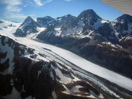
Upper half of the Tasman Glacier
|
|
| Type | Mountain glacier |
| Location | New Zealand |
| Coordinates | 43°37′S 170°12′E / 43.617°S 170.200°E |
| Area | 101 km2 (39 sq mi) |
| Length | 23.5 km (14.6 mi) |
| Thickness | 600 m (2,000 ft) |
| Terminus | Lake Tasman |
| Status | Retreating |
The Haupapa / Tasman Glacier is the biggest glacier in New Zealand. It's one of many large glaciers that flow from the Southern Alps in New Zealand's South Island. These glaciers move south and east towards the Mackenzie Basin.
Contents
What is the Tasman Glacier Like?
The Tasman Glacier is still New Zealand's longest glacier. It measures about 23.5 kilometres (14.6 mi) long. Even though it's shrinking, it's very wide, up to 4 kilometres (2.5 mi). It's also incredibly thick, about 600 metres (2,000 ft) deep.
Where is the Tasman Glacier Located?
This huge glacier is completely inside Aoraki / Mount Cook National Park. It covers an area of 101 square kilometres (39 sq mi). The glacier starts high up, at about 3,000 metres (9,800 ft) above sea level.
During winter and spring, a lot of snow falls on the glacier. Up to 50 metres (160 ft) of snow can pile up! After the summer sun melts some of it, about 7 metres (23 ft) of snow might still be left at the top.
How Does the Glacier Flow?
The Tasman Glacier flows southwest from Hochstetter Dome and Mount Elie De Beaumont. It moves along the southern side of The Minarets. It also flows south along the eastern side of New Zealand's two tallest mountains: Mount Tasman and Aoraki / Mount Cook.
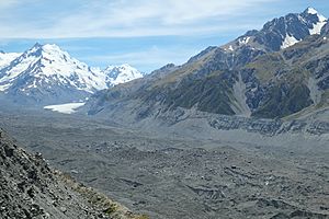
The top parts of the glacier are covered in snow. But as it moves, rocks get exposed. The lower part of the glacier is completely covered in rocks. This rock layer actually helps the ice. It acts like a blanket, protecting the ice from the sun and slowing down how fast it melts.
Where Does the Meltwater Go?
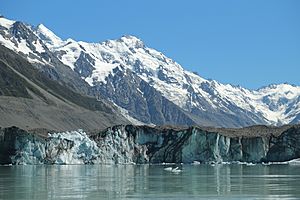
The water from the melting glacier forms a lake called Tasman Lake. Water from the Murchison Glacier also flows into Tasman Lake. The water from Tasman Lake then flows into the Tasman River. This river joins the Hooker River, which drains lakes from the Hooker and Mueller Glaciers.
The Tasman River has many small channels, looking like a braid. It flows south into Lake Pukaki. Eventually, all this water flows into the Waitaki River and then out to the Pacific Ocean.
Why is the Glacier Shrinking?
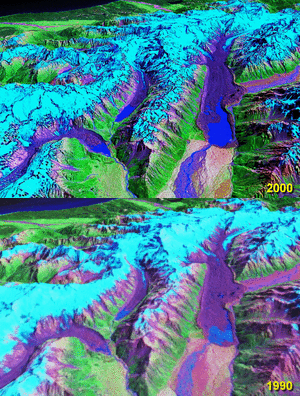
The Tasman Glacier stayed about 28 km (17 mi) long for most of the 1900s. But in the 1990s, it started melting very quickly. This is called a period of rapid retreat.
Between 2000 and 2008, the end of the glacier moved back 3.7 kilometres (2.3 mi). Since the 1990s, it has been shrinking by about 180 metres (590 ft) each year on average. Now, it's melting even faster, retreating between 477 to 822 metres (1,565 to 2,697 ft) every year. Scientists think the Tasman Glacier will eventually disappear. Tasman Lake will grow to its biggest size in the next 10 to 19 years. In 1973, there was no lake at the end of the glacier. By 2008, Tasman Lake was 7 kilometres (4.3 mi) long, 2 kilometres (1.2 mi) wide, and 245 metres (804 ft) deep.
What Caused the Ice to Break Off?
On February 22, 2011, a huge amount of ice broke off the glacier. This event, called calving, might have been caused or helped by the 2011 Christchurch earthquake. About 30 to 40 million metric tons of ice fell into Tasman Lake. Boats on the lake were hit by tsunami waves up to 3.5 metres (11 ft) high! Similar events have happened before, often linked to high water pressure under the glacier or higher lake levels after heavy rain.
How Can You Visit the Glacier?
People have been visiting the Tasman Glacier for a long time. Heli-skiing tours, where you fly by helicopter to ski on the upper glacier, started in the early 1970s. The nearby Ball Glacier was also popular for skiing, but it has shrunk too much to be safe now.
The glacier's ice loss has changed tourism. More cracks, called crevasses, are now exposed. This means guided tours are needed to avoid dangerous areas. The heli-skiing season is now shorter, only in July, August, and September.
Boat Tours on Tasman Lake
Tasman Lake is a popular place for boat tours. You can see icebergs floating in the lake. For safety, boats are not allowed closer than 1.5 km (0.9 mi) to the glacier's end. The glacier's face is about 50 m (160 ft) tall.
Walking Near the Glacier
The Ball Shelter Track is a walking path along the western side of the glacier. For about 6 kilometers, a tall wall of rocks, called a moraine wall, separates the path from Tasman Lake. After that, the path climbs higher, and you get a great view. From there, you can see the rock-covered lower Tasman Glacier, which is 2.5 km (1.6 mi) wide in the valley.
See also
 In Spanish: Glaciar Tasman para niños
- Glaciers of New Zealand
- List of glaciers
- Retreat of glaciers since 1850 – Oceania
 | Misty Copeland |
 | Raven Wilkinson |
 | Debra Austin |
 | Aesha Ash |


