Marlborough Sounds facts for kids

The Marlborough Sounds are a huge network of valleys at the northern end of the South Island of New Zealand. These valleys were once on land but are now filled with sea water. This happened because the land slowly sank and the sea level rose over time. According to Māori mythology, the sounds are like the front parts of sunken canoes belonging to Aoraki.
Contents
Exploring the Marlborough Sounds
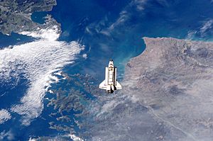
The Marlborough Sounds cover about 4,000 square kilometers (1,500 sq mi) of water, islands, and peninsulas. They are located at the very top-right of the South Island. To the west is Tasman Bay / Te Tai-o-Aorere, and to the south-east is Cloudy Bay. The coastline here is very wiggly, making up about one-tenth of New Zealand's entire coast.
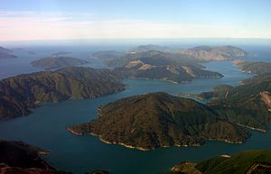
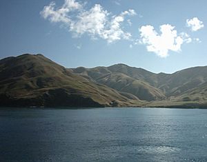
The sounds have steep, tree-covered hills and many small, quiet bays. Not many people live here because it's hard to get around. Many small towns and isolated homes can only be reached by boat. The main big port is Picton, located at the end of Queen Charlotte Sound. This is where the South Island's main railway and highway end. Another important port for smaller boats is Waikawa. It's one of New Zealand's biggest small-boat ports and is popular for people who love sailing and holidays.
Besides Queen Charlotte Sound, the other main sounds are Pelorus Sound and Kenepuru Sound. Tory Channel is a big part of Queen Charlotte Sound. Together, Tory Channel and Queen Charlotte Sound separate the hills of Arapaoa Island from the mainland. Another large island in the sounds is D'Urville Island.
The sounds are home to a special bird called the New Zealand king shag. This rare and vulnerable bird only breeds on a few rocky islets in the Marlborough Sounds. The Department of Conservation looks after more than 50 nature reserves in this area.
History of the Sounds
Early Māori Life
Before Europeans arrived, Māori groups often traveled through and lived in the sounds. They used the sounds as a safe place from bad weather. They also found lots of food there. Māori people would sometimes carry their canoes over land on special paths called portages. However, fewer people lived in the South Island compared to the North Island.
European Arrival and Whaling
European history in the area began when Captain Cook visited the sounds in the 1770s. He found a plant called Cook's scurvy grass, which was full of vitamin C. This plant helped cure scurvy among his crew. On Motuara Island, Cook also claimed the South Island for Britain. Later, some parts of the sounds became important for whaling. Many European farmers also settled in the sounds in the late 1800s and early 1900s.
Ferries and Marine Farming
The Marlborough Sounds connect to Cook Strait at their north-eastern end. This is where the North Island is closest to the South Island. Ferries that carry cars, trains, and people travel through the sounds between Picton and Wellington.
Growing seafood like salmon and mussels in marine farms has become very common since the 1960s. However, the large waves created by fast ferries used to cause problems. People said these waves damaged marine farms and destroyed places where crabs lived. They were also blamed for washing sand away from beaches and harming docks.
A group called the 'Guardians of the Sounds' took this issue to court in the early 1990s. The court did not stop the fast ferries. The group also had to pay a large amount for court costs. This made it harder for groups to take legal action like this.
But as more damage became clear, and protests continued, the fast ferries were eventually told to slow down to 18 knots (about 33 km/h) in the sounds. This was officially for safety reasons. This reduced their speed advantage over regular ferries. These fast ferries are no longer used.
In 2007, the 'Guardians of the Sounds' group planned a big protest. They wanted to stop scallop dredging in the sounds. They believed this method, which involves dragging nets along the seabed, harmed the ecosystem. They said it was like bottom trawling in the open sea. The protest aimed to show that the Ministry of Fisheries was not paying enough attention to this problem. Scallop harvesting companies warned that protests could be dangerous. The Ministry of Fisheries also noted that only a small part of the sounds (6%) was used for dredging, though it had been much more in the past.
The main channels of the Marlborough Sounds have calm water and are popular for sailing. However, Cook Strait is known for its strong currents and rough waters. This is especially true when the wind blows from the south or north. Because of this, some narrow channels closer to the Strait can be dangerous to navigate. One well-known dangerous spot is French Pass, at the southern end of D'Urville Island, which has strong currents.
The most famous shipwreck in the sounds is the Russian cruise ship MS Mikhail Lermontov. It sank in 1986 in Port Gore, near the entrance to Queen Charlotte Sound. This happened after it hit some rocks. One crew member died in the accident. The ship itself is now a popular place for scuba divers.
See also
 In Spanish: Marlborough Sounds para niños
 | Victor J. Glover |
 | Yvonne Cagle |
 | Jeanette Epps |
 | Bernard A. Harris Jr. |


