Arapaoa Island facts for kids

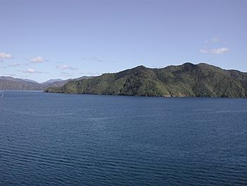
Southern end of Arapaoa Island
|
|

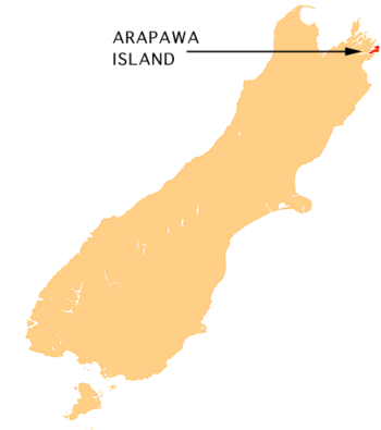
Arapaoa Island relative to the South Island
|
|
| Geography | |
|---|---|
| Location | Marlborough Sounds |
| Coordinates | 41°11′22″S 174°18′10″E / 41.18951°S 174.30290°E |
| Area | 75 km2 (29 sq mi) |
| Length | 28 km (17.4 mi) |
| Width | 4 km (2.5 mi) |
| Highest elevation | 559.4 m (1,835.3 ft) |
| Highest point | Narawhia |
| Administration | |
|
New Zealand
|
|
| Region | Marlborough District |
| Demographics | |
| Population | 50 |
Arapaoa Island is the second-largest island in the Marlborough Sounds. It is located at the north-east tip of the South Island of New Zealand. The island covers an area of about 75 km2 (29 square miles). Queen Charlotte Sound is on its western side. To the south is Tory Channel, a busy sea route between Wellington in the North Island and Picton. The narrowest part of Cook Strait is between Arapaoa Island's Perano Head and Cape Terawhiti in the North Island. In 2014, the island's name was officially changed from Arapawa to Arapaoa.
Contents
Island History
Māori Legends and Early Explorers
According to Māori stories, Arapaoa Island is where the famous navigator Kupe fought and killed a giant octopus named Te Wheke-a-Muturangi.
In 1770, Captain James Cook stood on a hill on Arapaoa Island. From there, he saw the sea passage connecting the Pacific Ocean to the Tasman Sea. This confirmed what the local Māori people had told him: Aotearoa (New Zealand) is made up of two main islands. It is believed that Joseph Banks named Cook Strait after Captain Cook. This discovery proved that the idea of a huge southern continent, Terra Australis, was not true. A special monument was put up at Cook's Lookout in 1970 to remember this event.
Whaling Past and Present Whale Spotting
From the late 1820s until the mid-1960s, Arapaoa Island was an important base for whaling in the Sounds. John Guard set up a whaling station at Te Awaiti in 1827. At first, they could only collect baleen, which is a filter-feeding system from whales. From 1830, they started processing whale oil from right whales.
Later, from 1911 to 1964, a station at Perano Head on the island's east coast was used to hunt humpback whales. The houses built by the Perano family are now used for tourist accommodation. In the 2000s, former whalers from the Perano and Heberley families, who live on Arapaoa, joined a special program. This program, run by the Department of Conservation, helps to count humpback whales. This helps scientists see how much the whale population has grown since whaling stopped.
Conservation Efforts
Protecting Native Plants
In the past, much of Arapaoa Island's native bush was cleared by burning and logging. Pine forests were then planted. Now, wilding pines, which are trees that spread too much in some parts of New Zealand, are being removed. Workers drill holes into these trees and inject poison to kill them. This allows the original native plants to grow back. About 200 hectares (490 acres) at Ruaomoko Point, on the south-eastern part of the island, is part of this effort.
Unique Island Animals
Arapaoa Island is famous for its special breeds of farm animals. These include the Arapawa pig, Arapawa sheep, and Arapawa goat. These animals have lived on the island since the 1800s. No one is completely sure how they got there. Some people think they are old English breeds brought by early whalers or by Captain Cook. These breeds are now extinct in England. The Arapaoa goats are kept safe in a special sanctuary on the island. They are also now bred in other parts of New Zealand and in the northern hemisphere.
The small Brothers Islands are located off the north-east coast of Arapaoa Island. These islands are a safe home for the rare Brothers Island tuatara.
See also
 In Spanish: Isla de Arapaoa para niños
 | Delilah Pierce |
 | Gordon Parks |
 | Augusta Savage |
 | Charles Ethan Porter |

