
Queen Charlotte Sound / Tōtaranui facts for kids
Quick facts for kids Queen Charlotte Sound / Tōtaranui |
|
|---|---|

Queen Charlotte Sound
|
|

Queen Charlotte Sound / Tōtaranui
Location in Marlborough Sounds

Queen Charlotte Sound / Tōtaranui
Location in New Zealand
|
|
| Location | Marlborough Region, New Zealand |
| Coordinates | 41°15′00.00″S 174°00′57.18″E / 41.2500000°S 174.0158833°E |
| Type | Ria |
| Native name | Tōtaranui (Māori) |
| Part of | Marlborough Sounds |
| Islands | Arapaoa Island, Allports Island, Blumine Island, Motuara Island, Long Island |
| Settlements | Picton |
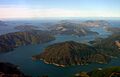
Queen Charlotte Sound / Tōtaranui is a beautiful inlet of the sea. It is located in the Marlborough Sounds area of New Zealand. You can find it on the eastern side of the South Island.
In 2014, this sound was given its official dual name. This happened as part of a special agreement. It was a settlement with the Te Āti Awa Māori tribe.
Contents
Exploring the Geography of the Sound
Like many other sounds nearby, Queen Charlotte Sound stretches from southwest to northeast. It eventually connects with the Cook Strait.
Islands and Waterways
To the east of the sound, you will find Arapaoa Island and Tory Channel. Large ferries use Tory Channel and Queen Charlotte Sound. They travel between Picton in the South Island and Wellington in the North Island.
To the northwest is Kenepuru Sound. This is an arm of Pelorus Sound. It runs right next to Queen Charlotte Sound. Some small parts of these two sounds are very close. They are only a few hundred meters apart. However, a steep range of hills separates them. One town in this area is called Portage. It got its name because it was the easiest way to cross between the two sounds.
The sound itself is a "drowned river valley." This means it was once a river valley that filled with seawater. This type of landform is also called a ria.
Towns and Settlements in the Sound
The main town in the area is Picton. It sits near the very end of the sound. Picton is an important transport hub. It is the northern end of the South Island's railway and state highway systems.
Other places to live along the sound are much smaller. They are often just single homes or small groups of houses. The coast here is very rugged and steep. Because of this, many of these places can only be reached by boat.
A Look at the Sound's History
For a long time, Queen Charlotte Sound was a key trading spot. This was especially true before Europeans arrived. Māori people from the North and South Islands traded here. They exchanged things like pakohe, a special stone. This stone was used to make tools called toki, or adzes.
Captain Cook's Visits
In 1770, Captain James Cook stood on a hill on Arapaoa Island. From there, he saw the sea passage for the first time. This passage connects the Pacific Ocean to the Tasman Sea. It was later named Cook Strait after him. Captain Cook visited Queen Charlotte Sound many times. He stopped there during each of his three big voyages of exploration. He named the sound after Queen Consort Charlotte of Mecklenburg-Strelitz.
Whaling and Shipwrecks
During the 1800s and early 1900s, the area was a base for whaling. Whaling was the hunting of whales. A famous whaling spot was Perano Head on Arapaoa Island.
Queen Charlotte Sound has calm waters. This makes it a popular place for sailing. This is very different from the often rough waters of Cook Strait. Many ships have been wrecked near the entrance to the Sound. One well-known event was in 1986. The Russian cruise ship Mikhail Lermontov sank after hitting rocks. This happened in Port Gore. Sadly, one person lost their life in this accident.
Images for kids
-
Tory Channel, a major arm of Queen Charlotte Sound
-

The entrance to Queen Charlotte Sound

