Pelorus Sound / Te Hoiere facts for kids
Quick facts for kids Pelorus Sound / Te Hoiere |
|
|---|---|
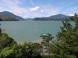
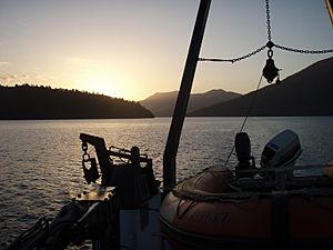
Moetapu Bay in inner Pelorus Sound / Te Hoiere
|
|
| Location | Marlborough Region, New Zealand |
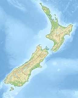
| Coordinates | 41°10′07″S 173°52′07″E / 41.168575°S 173.868542°E |
| Type | Ria |
| Native name | Te Hoiere Error {{native name checker}}: parameter value is malformed (help) |
| Part of | Marlborough Sounds |
| Max. length | 55 kilometres (34 mi) |
| Shore length1 | 380 kilometres (240 mi) |
| Islands | Maud Island |
| Settlements | Havelock |
| 1 Shore length is not a well-defined measure. | |
Pelorus Sound / Te Hoiere is the largest of the sounds (deep inlets of the sea) that make up the Marlborough Sounds. These are found at the top of the South Island in New Zealand. The Marlborough Sounds are like old river valleys that got filled with water. This happened after the last ice age, about 10,000 years ago.
Pelorus Sound has a main waterway that stretches about 55 kilometers (34 miles) south from Cook Strait. It winds through hills covered in trees, ending near the town of Havelock. The sound has many smaller arms, like Tennyson Inlet, Tawhitinui Reach, Kenepuru Sound, and the Crail/Clova/Beatrix Bay areas. Its shoreline is very long, stretching for about 380 kilometers (240 miles).
The main activities in Pelorus Sound are marine farming (like growing mussels), pine tree farming, and some tourism. More and more private holiday homes are being built here. Most places in the sound are hard to reach by road. They are served by the Pelorus Express, a mail boat that delivers mail and supplies three times a week from Havelock.
Maud Island, also known as Te Hoiere in the Māori language, is a 310-hectare (770-acre) island in Pelorus Sound. It is a very important nature reserve. Only scientists and people working on conservation are allowed to visit it.
Contents
History of Pelorus Sound
The local iwi (tribe) of the Māori people in this area is the Ngāti Kuia. According to their traditional stories, their ancestor, a descendant of Kupe, came to the South Island in his waka (canoe) called Te Hoiere.
In 1642, the Dutch explorer Abel Tasman sailed past D'Urville Island. Later, French and Russian explorers visited the area. In the 1770s, Captain James Cook arrived.
In 1838, Philip Chetwode, commanding the ship HMS Pelorus, made the first detailed map of Pelorus Sound. The sound was named after his ship to honor this important survey. A pelorus is a navigation tool used on ships. The tool itself was named after Hannibal's pilot, who lived around 203 BC.
In 1864, gold was found in the Wakamarina Valley. For a short time, Havelock became a very busy town as thousands of gold seekers rushed to the area.
In 1865, the first timber mill opened at Mahikipawa, an arm of Pelorus Sound. More mills were built, and native timber was sent all over New Zealand and to Australia. By the early 1900s, most timber camps had closed. They were replaced by dairy and sheep farms. The last mill closed in 1939. About 325 million feet of timber had been cut over sixty years, leaving only two small areas of native forest.
Pelorus Jack the Dolphin
In 1888, a Risso's dolphin appeared in the sounds. This dolphin became famous as Pelorus Jack. He was the first dolphin in the world to be protected by law. Pelorus Jack would swim with boats going to and from the tricky French Pass.
He would join boats heading for Nelson at the entrance to Pelorus Sound. For about eight kilometers (5 miles), he would ride the waves at the front of their boats. He never went through the pass with them. Instead, he would meet returning boats as they came out of the pass. Pelorus Jack was last seen in April 1912. The lighthouse keeper at French Pass said he found Pelorus Jack's body on the shore.
During World War II, special defenses were built on Maud Island. These were meant to protect Cook Strait and the entrance to the sound. These defenses included a large gun and equipment for finding targets, which are still there today.
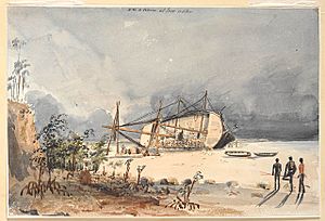
In 1906, New Zealand bought its first naval ship. It was a sail training ship called NZS Amokura. In 1922, it became a coal storage ship. In 1953, it was towed into St Omer Bay in Kenepuru Sound, an arm of Pelorus Sound. It was used there as a storage ship and a small dock. Although it was reported broken up in 1955, its remains can still be found on the beach in the southern part of the bay.
In August 2014, the official name of the sound was changed to Pelorus Sound / Te Hoiere.
Industries in Pelorus Sound
Marine Farming
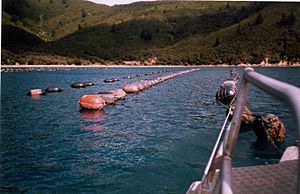
More than 80 percent of New Zealand’s aquaculture exports come from the Marlborough Sounds. This is worth over $NZ 200 million each year. Most of these marine farms are in Pelorus Sound. The main product exported is green-lipped mussels.
A New Zealand sea sponge called Mycale hentscheli grows in Pelorus Sound. Scientists believe it might contain a substance that could help fight cancer. This substance is called peloruside. Scientists are working with marine farmers to learn how to grow this sponge on existing mussel farms.
Trial mussel farms started in the Marlborough Sounds in the late 1960s. In Pelorus Sound, mussel farms first began in Kenepuru Sound and Crail Bay. Since then, Pelorus has become the biggest mussel-producing area in New Zealand.
At first, mussels were grown on ropes hanging from rafts. This took a lot of work. Now, a different system is used. Mussel babies (spat) are put into special stockings and hung from long ropes supported by buoys.
In 1981, the first factory designed just for processing mussels opened in Havelock. Havelock is now the main place where harvested mussels are brought. There are also smaller processing plants in French Pass, Elaine Bay, Okiwi Bay, and Rai Valley. Many people work in the mussel farming industry, managing farms, harvesting mussels, and transporting them. This industry is very important to several local communities.
Sometimes, heavy rain can cause rivers to carry a lot of dirt and bacteria from farms into the sound. This can lead to mussel farming areas being closed for harvesting to keep people safe.
There have been disagreements about expanding mussel farms. For example, plans to add more mussel farms in Admiralty Bay were stopped. This area is a special feeding spot for Dusky dolphins. Some studies suggest that marine farms might make it harder for dusky dolphins to find and catch fish like pilchards. Chinook Salmon are also farmed in the outer Pelorus Sound. Salmon farming in the sounds might grow more in the future.
Pine Forestry
Since the 1970s, large areas of non-native (pine) trees have been planted around the sounds. The cut timber is shipped from a deep-water dock in Shakespeare Bay, which is west of Picton.
Māori People and the Sound
The Māori people are the native people of New Zealand. The local iwi (tribes) like Ngāti Kuia, Ngāti Koata, and Ngāti Toa are involved in marine farming. They hope this will create better jobs for their people.
They also care deeply about protecting their sacred sites and worry about how large-scale marine farming affects the environment. They have sometimes opposed new projects, like a mussel farm in an area where their people are returning to live. They also opposed a planned harbor development in Havelock, where a local dump was near sacred sites and a waterway important to Ngāti Kuia.
Māori groups are now better able to protect their interests. This is because of agreements and money they receive from fishing rights. This has sometimes caused tension in the community, with some people feeling that Māori groups slow down development.
Water Movement in Pelorus Sound
Scientists have studied how water moves in Pelorus Sound. They found that the amount of fresh water flowing into the sound is very important and changes a lot. The sound has 380 kilometers (240 miles) of shoreline and covers an area of 290 square kilometers (110 square miles).
On average, 99 cubic meters (3,500 cubic feet) of fresh water flow into the sound every second. The Pelorus River and Kaituna River at the head of the sound provide most of this water. Rain falling directly on the sound's surface also adds water. The rest comes from small streams nearby.
This fresh water creates a special water flow in the main channel. Lighter, less salty water moves outwards at the surface. Heavier, saltier water flows inwards underneath. The currents in the main channel are usually slow, but they can become much stronger right after heavy rain. After a big flood, it takes about 21 days for the fresh water to be flushed out of the sound.
The tides at the entrance to Pelorus Sound are like most places in New Zealand. There are two high tides and two low tides each day. The height of the tide changes between spring tides (very high and low) and neap tides (less difference). The tide can range from 1.0 to 1.3 meters (3.3 to 4.3 feet) during neap tides and 2.1 to 2.4 meters (6.9 to 7.9 feet) during spring tides. Because the sound is long and narrow in some places, the tidal currents can be quite strong.
Wind also affects the water in Pelorus Sound. Winds in the area are often strong and are guided by the steep hills. Wind pushing on the water's surface creates currents. Wind also mixes the fresh surface water with the saltier water below. This creates a layer of brackish (slightly salty) water, usually 5 to 15 meters (16 to 49 feet) thick.
Timeline of Pelorus Sound
- Ancient Times: The founding ancestor of the Ngāti Kuia tribe arrives in the South Island in his canoe, Te Hoiere.
- 1642: Abel Tasman sails past D'Urville Island.
- Late 17th Century: French and Russian explorers arrive.
- 1770s: Captain James Cook arrives.
- 1827: Jules Dumont d'Urville has a difficult journey through French Pass in his ship Astrolabe.
- 1838: HMS Pelorus carries out the first survey of the sound. The sound is named after this ship.
- 1864: Gold is discovered in the Wakamarina Valley, making Havelock a busy town for a short time.
- 1865: The cutting of native timber begins.
- 1870: A mill for processing flax starts working on the Ruapeka Stream.
- 1888: The famous dolphin Pelorus Jack is first seen.
- Around 1900: Timber camps are mostly replaced by dairy and sheep farms.
- 1912: Pelorus Jack dies.
- 1939: The last native timber mill closes. Only small areas of native forest remain.
- 1942: Coastal defenses are built on Maud Island to protect Cook Strait and the sound's entrance.
- 1953: NZS Amokura, New Zealand's first naval ship, is towed into St Omer Bay in Kenepuru Sound and left on the beach, where its remains are still found.
- 1960s: There is a drop in catches of fish and scallops, as some wild fisheries suffer from too much fishing.
- Late 1960s: Mussel farming begins.
- 1981: The first factory specifically for processing mussels is built in Havelock.
 | Georgia Louise Harris Brown |
 | Julian Abele |
 | Norma Merrick Sklarek |
 | William Sidney Pittman |


