
Coastal fortifications of New Zealand facts for kids

Coastal forts were built in New Zealand at two main times. The first was around 1885, when people worried about an attack from Russia. The second was during World War II, when there were fears of an invasion by Japan.
These forts were designed based on plans from Britain, but they were changed to fit New Zealand's needs. They usually had places for big guns, small bunkers (called pill boxes), and spots for watching the sea. They also used camouflage to hide from enemies. Underground, there were bunkers, sometimes with tunnels connecting them. These bunkers held ammunition, supplies, and special rooms to plan attacks. They also had engines to power the big guns and searchlights. Soldiers living at the forts had kitchens, barracks (sleeping areas), and rooms for officers.
Contents
The "Russian Scare" Forts of 1885
In the 1870s, New Zealand was a young country that governed itself, but it was still part of Britain. It didn't have many ways to defend its harbours. People started to worry about attacks from other countries, especially the growing Russian Empire. Russia had even built a port in the Pacific called Vladivostok.
These fears grew stronger after a fake newspaper story came out in 1873. The article claimed that a Russian warship had attacked Auckland! It said the ship had captured a British vessel, taken weapons, and held important citizens for ransom. The story was a hoax, but it made people realize how unprotected New Zealand was.
The government then started looking into how to defend the country. Britain would protect its main territories, but each self-governing colony was responsible for defending its own ports. When Russia declared war on Turkey in 1877, the "scare" happened again.
In 1884, Sir William Jervois, who was the Governor of New Zealand, suggested building military forts. These forts would be at New Zealand's four main ports: Auckland, Wellington, Lyttelton, and Port Chalmers. The plans for these coastal artillery forts came from British designs. Big guns and ammunition were ordered from Britain. By 1885, work began on building seventeen forts, pushed along by another "Russian scare."
Big Guns of the 1880s

In 1885, New Zealand bought ten Armstrong 8-inch guns and thirteen Armstrong 6-inch guns. These guns were special because they were "disappearing guns." This meant that after they fired, the force of the shot pushed the gun back underground. This allowed soldiers to reload it safely, hidden from enemy fire. This was very new technology back then!
These guns were very expensive. The 8-inch guns weighed 13.5 tons and could fire a 180-pound shell up to 4 miles. The 6-inch guns weighed 5 tons and fired a 100-pound shell up to 3 miles. The total cost for these guns, plus building the forts, magazines, and barracks, was about £160,000. That was a huge amount of money at the time!
Key "Russian Scare" Forts
Many forts were built during this time. Here are some of the most important ones:
- North Head (Auckland): This fort was built in 1870 and had several gun batteries. It was designed to protect the channels leading into Auckland Harbour.
- Fort Victoria (Auckland): Located on Mount Victoria in Devonport, this fort had an 8-inch gun. It only fired once because the loud noise broke windows in nearby homes!
- Fort Ballance (Wellington): Built in 1885, this was Wellington's main military fort until 1911.
- Fort Jervois (Lyttelton): This fort was built on Ripapa Island in 1886. It's very special because it still has its original "disappearing guns" and is one of only five such forts left in the world! It's now looked after by the Department of Conservation.
- Fort Taiaroa (Port Chalmers): Built in 1885, this fort in Otago Harbour has an Armstrong Disappearing Gun. It's the only one of its kind that still works and is in its original spot!
World War II Coastal Forts

The second big wave of building coastal forts happened during World War II. This was mainly because New Zealand feared an invasion from Japan after the attack on Pearl Harbor in 1941. From 1942 to 1944, when the danger lessened, 42 coastal artillery forts were either updated or built from scratch.
Like before, these forts used British designs that were changed for New Zealand. A new technology called Radar was also used. Radar helped the guns shoot accurately even at night, which was a big improvement over older ways of finding targets.
Guns of World War II

The forts used both old and new guns, mostly from Britain. Some guns from World War I were even taken from museums and put back into service! The biggest guns were the 9.2-inch guns, which could shoot up to 18 miles! Other common guns included 6-inch Mark 7 guns and 4-inch Mark 7 guns. American naval guns were also used.
Important World War II Forts
The forts were managed by the Royal New Zealand Artillery. They were grouped into four main areas, each with its own command center. Seven of the old "Russian scare" forts were also used again during World War II.
Upper North Island Forts
These forts protected places like Auckland and the Bay of Islands.
- Motutapu Island: This fort had three 6-inch guns and was used from 1936 to 1945. It also had underground magazines for ammunition.
- North Head: This old "Russian scare" fort became an administration center during WWII. It still has many tunnels, guns, and searchlights, and is now a historic reserve.
- Bastion Point: Another old fort, its tunnels were rediscovered later after being buried when the Michael Joseph Savage memorial was built.
- Stony Batter (Waiheke Island): This fort had two powerful 9.2-inch guns that could shoot 18 miles. It is now looked after by the Department of Conservation.
- Castor Bay: This fort was known for its clever camouflage during the war to hide it from enemy planes.
Lower North Island Forts
These forts protected Wellington and other central North Island areas.
- Palmer Head (Wellington): This fort had three 6-inch guns. The gun pits were later destroyed, but some underground rooms remain.
- Fort Dorset (Wellington): Located at the entrance to Wellington Harbour, this fort was used until 1991 before being taken down.
- Fort Ballance (Wellington): This "Russian scare" fort was used again until 1945.
- Wrights Hill Fortress (Wellington): This huge fortress was similar to Stony Batter. It had two 9.2-inch guns and over 2,000 feet of connecting tunnels! It could fire shells across Cook Strait. The guns were sold for scrap in the 1960s, but a group is working to restore the fortress.
Upper South Island Forts
These forts protected places like Lyttelton and the Marlborough Sounds.
- Godley Head (Lyttelton): Located at the entrance to Lyttelton Harbour, this was the last New Zealand fort to be closed down in 1963. It was a busy place during WWII, with over 400 men and women working there. It's now a top heritage site and is looked after by the Department of Conservation.
- Fort Jervois (Lyttelton): This historic "Russian scare" fort was also used during WWII.
- Blumine Island (Queen Charlotte Sound): This island had two 6-inch guns to guard the northern entrance to the sound.
Lower South Island Forts
These forts protected places like Dunedin and Bluff.
- Fort Taiaroa (Port Chalmers): This "Russian scare" fort was recommissioned during WWII. Its Armstrong Disappearing Gun is still working and open to the public!
- Cape Wanbrow (Oamaru): This fort had a 5-inch American gun and is now looked after by a local restoration group.
After the Wars
After World War II, new ways of fighting like air warfare and missiles made these big forts less useful. Most of them were closed down by the 1950s. Godley Head stayed open a bit longer for military training. The Department of Conservation now looks after the remains of about 30 of these old military sites.
Interesting Facts
None of these forts ever fired their guns at an enemy in a real battle. However, in October 1939, a gun at Battery Point in Lyttelton accidentally sank a fishing boat called "Dolphin" and sadly killed its captain.
In 1972, the United States revealed an old secret plan from 1908 for invading New Zealand. This plan was called Naval War Plan for the Attack of Auckland, New Zealand. It suggested that Manukau Harbour would be the best place to invade. The plan also suggested landing big guns on Rangitoto Island to bomb the forts on the North Shore. This plan wasn't very realistic and was probably just an exercise to keep young officers busy!
Images for kids
-
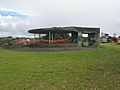
A bunker at Castor Bay, known for its camouflage.
-
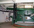
The Armstrong disappearing gun at Taiaroa Head.


