D'Urville Island facts for kids
|
Native name:
Rangitoto ki te Tonga (Māori)
|
|
|---|---|

D'Urville Island and Tasman Bay
|
|

Location of D'Urville Island
|
|
| Geography | |
| Coordinates | 40°50′S 173°52′E / 40.833°S 173.867°E |
| Area | 150 km2 (58 sq mi) |
| Highest elevation | 729 m (2,392 ft) |
| Highest point | Attempt Hill |
| Administration | |
| Region | Marlborough District |
| Demographics | |
| Population | 52 |
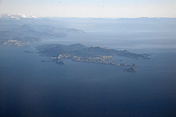
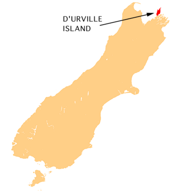
D'Urville Island, also known by its Māori name Rangitoto ki te Tonga, is a large island in New Zealand. It is the biggest island in the Marlborough Sounds, located off the northern coast of the South Island.
The island was named after a French explorer, Jules Dumont d'Urville. It covers about 150 square kilometers (58 square miles). This makes it the eighth-largest island in New Zealand. Around 52 people live there permanently. The local government for the island is the Marlborough District Council.
Contents
History of D'Urville Island
The original Māori name for the island was Rangitoto. This name means "blood red sky." It is a very old name that Māori people brought from their homeland, Hawaiki. Later, the name became Rangitoto ki te Tonga. The "ki te Tonga" part means "of the south." This helped people tell it apart from other places called Rangitoto in the North Island. Today, the island's official name is Rangitoto ki te Tonga / D'Urville Island.
Stone Tools from the Island
For a long time, D'Urville Island was an important place for Māori. They found a special type of stone there called argillite (pakohe). This stone was perfect for making tools like adzes. Adzes are like axes, used for carving wood and other tasks. These tools were made during the Archaic period, from about 1300 to 1500.
Māori Tribes and the Island
From the 1600s to the early 1800s, the island was part of the land of the Ngāti Tūmatakōkiri tribe. Today, D'Urville Island is within the traditional lands of the Ngāti Koata and Ngāti Kuia tribes.
Geography of D'Urville Island
D'Urville Island has a very twisty coastline. This is common for islands that were once mountain peaks in valleys that later filled with sea water. The island stretches about 35 kilometers (22 miles) from northeast to southwest. At its widest point, it is a little over 10 kilometers (6 miles) across.
Coasts and Harbours
The eastern coast of the island is fairly smooth. It has a small area called the D'Urville Peninsula. The western coast is much more rugged. It has three large inlets: Port Hardy in the north, Greville Harbour in the middle, and Manuhakapakapa in the south. Many smaller islands are found near D'Urville Island. One important one is Stephens Island, which is about 3 kilometers (2 miles) north of D'Urville's northernmost point, Cape Stephens.
Highest Point and Settlements
The highest point on the island is Takapōtaka / Attempt Hill. It is 729 meters (2,392 feet) tall. This hill is near the center of the island, east of Greville Harbour. Most of the people living on D'Urville Island live closer to the calmer east coast. The small communities of Patuki and Mukahanga are near the northern tip of the island.
The French Pass
The island is separated from the mainland by a narrow, tricky waterway called French Pass. Māori know it as Te Aumiti. Water rushes through this pass very quickly, up to 8 knots (15 km/h or 9 mph) with each tide. This strong current can create several whirlpools. In 1827, explorer d'Urville studied the pass for several days. His ship was damaged when he finally sailed through it.
Animals and Plants on D'Urville Island
About 6,000 hectares (60 square kilometers) of D'Urville Island is public conservation land. This land is mostly in the center of the island. It includes areas where old farms are growing back into nature, coastal forests, and beech forests.
Protecting Native Wildlife
D'Urville Island is special because it does not have many harmful animals. There are no possums, wild goats, ship rats, Norway rats, or weasels. This makes it a very important place for native wildlife. However, Red deer and feral pigs do live on the island. People can get a permit from the Department of Conservation to hunt these animals on the public land.
Stopping Stoats
Unfortunately, stoats are present on the island. Stoats are small, fierce predators that have caused problems for native birds. Because of stoats, birds like the little spotted kiwi, South Island kākā, and yellow-crowned kākāriki are no longer found on the island. In 2003, a group called the D'Urville Island Stoat Eradication Charitable Trust started working to remove stoats from the island. A big project to get rid of stoats was planned, but it faced problems with land access and the funding was stopped.
Rare Bats
The island is also home to a population of the rare South Island long-tailed bat. These bats are a special part of New Zealand's wildlife.
Getting to D'Urville Island
There are a few ways to reach D'Urville Island.
Flights and Boats
- There is a small airstrip at Moawhitu, in Greville Harbour. The Department of Conservation takes care of it.
- Pelorus Air offers flights to D'Urville Island from Picton, Wellington, and Paraparaumu.
- A barge service is run by D'Urville Island Crossings. It travels between French Pass village and the settlement of Kapowai.
- A water taxi also operates between the D’Urville Island Wilderness Resort at Catherine Cove and French Pass.
Tours and Charity
- Driftwood Eco Tours offers small group trips to the island. These tours focus on the island's history and nature. They also allow visitors to meet residents and learn about the island. Driftwood Eco Tours donates money each year to the D'Urville Island Stoat Eradication Trust.
- In 2016, Abel Tasman Sea Shuttles, based in Motueka, hosted charity cruises around D'Urville Island. They worked with the Rotary Club of Motueka to raise money.
See also
 In Spanish: Isla D'Urville (Nueva Zelanda) para niños
 | Laphonza Butler |
 | Daisy Bates |
 | Elizabeth Piper Ensley |

