D'Urville Island, Antarctica facts for kids

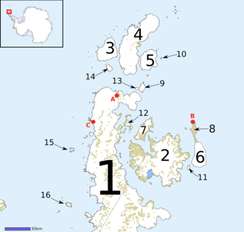
Map of Graham Land, showing D'Urville Island (3)
|
|
|
Location in Antarctica
|
|
| Geography | |
|---|---|
| Location | Antarctica |
| Coordinates | 63°05′S 56°20′W / 63.083°S 56.333°W |
| Archipelago | Joinville Island group |
| Area | 455.3 km2 (175.8 sq mi) |
| Length | 27 km (16.8 mi) |
| Administration | |
| Administered under the Antarctic Treaty System | |
| Demographics | |
| Population | Uninhabited |
D'Urville Island is an island located in Antarctica, a continent covered mostly by ice. It is the northernmost island in a group called the Joinville Island group. This island is about 27 kilometers (17 miles) long.
D'Urville Island lies just north of Joinville Island. A narrow waterway called Larsen Channel separates these two islands. Another passage, Burden Passage, separates D'Urville Island from Bransfield Island.
Contents
Exploring D'Urville Island
How was D'Urville Island discovered?
D'Urville Island was first mapped in 1902. This important work was done by the Swedish Antarctic Expedition. The expedition was led by a brave explorer named Otto Nordenskiöld.
Who is D'Urville Island named after?
Nordenskiöld named the island after Jules Dumont d'Urville. He was a famous French explorer and a captain in the navy. Jules Dumont d'Urville was known for discovering land in the Joinville Island group much earlier.
See also
In Spanish: Isla D'Urville (Antártida) para niños
 | John T. Biggers |
 | Thomas Blackshear |
 | Mark Bradford |
 | Beverly Buchanan |


