
Motueka facts for kids
Quick facts for kids
Motueka
|
|
|---|---|
|
Town
|
|
,_Skydiving.jpg)
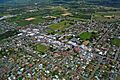
An aerial view of Motueka looking east
|
|
| Nickname(s):
"Mot"
|
|
| Country | New Zealand |
| Territorial authority | Tasman |
| Ward | Motueka Ward |
| Community | Motueka Community |
| Electorates |
|
| Area | |
| • Total | 12.68 km2 (4.90 sq mi) |
| Population
(June 2023)
|
|
| • Total | 8,320 |
| • Density | 656.2/km2 (1,699.4/sq mi) |
| Time zone | UTC+12 (NZST) |
| • Summer (DST) | UTC+13 (NZDT) |
| Postal codes |
7120, 7196, 7197, 7198
|
| Area code | 03 |
| Website | www.lovemotueka.com |
Motueka is a town in New Zealand, located on the South Island. It sits near the mouth of the Motueka River, on the western side of Tasman Bay. It's the second biggest town in the Tasman Region, with about 8,320 people living there.
The area around Motueka is known for its many farms. They grow apples, pears, and kiwifruit. You can also find special crops like hops here. Long ago, this area was the main place for growing tobacco in New Zealand. This continued until the early 1980s. Now, some small vineyards (places where grapes are grown for wine) have also started up.
Motueka is a popular spot for holidays. Nearby beaches like Kaiteriteri and Mārahau attract many visitors. The region gets a lot of sunshine each year, making it a great place to visit. Riwaka is just 4.8 km north of Motueka. The city of Nelson is about 41.7 km to the east.
Because Motueka is close to the Abel Tasman and Kahurangi National Parks, it has become a hub for tourism. Many people come here for outdoor adventures. You can explore amazing limestone cave systems, like Harwoods Hole. These caves attract people who enjoy caving and rock climbing. Activities like sea kayaking, tramping (hiking), and canyoning bring thousands of visitors every year.
Many artists live in the Motueka area, especially potters and reggae musicians. The Riverside Community is a special place nearby. It's a pacifist community where people live together cooperatively. It was started in the 1940s and is New Zealand's oldest community of its kind.
Contents
- What's in a Name?
- A Look Back at Motueka's Past
- People of Motueka
- Motueka's Geography and Weather
- Churches and Places of Worship
- Fun Things to Do in Motueka
- Motueka's Economy
- Learning in Motueka
- Media and News
- Getting Around Motueka
- Culture and Arts
- Sports and Recreation
- Sister City
- Famous People from Motueka
- Images for kids
- See Also
What's in a Name?
The name Motueka comes from the Māori language. It means weka island. A weka is a type of bird that looks a bit like a chicken. Some people who live in Motueka like to call it "Mot" for short.
A Look Back at Motueka's Past

The first European explorer known to visit the coast near Motueka was Jules Dumont d'Urville in 1827. He was a French explorer who sailed on a ship called the Astrolabe. He explored and described a lot of the Tasman Bay coastline.
In 1841, three ships from the New Zealand Company's Nelson expedition arrived. They anchored north of Kaiteriteri Beach, which is about 16 km north of Motueka. Kaiteriteri was first chosen as a place for a new settlement, but later, people decided to build in Nelson Haven instead.
Motueka became a town in 1842 because its soil was very fertile. This meant it was great for farming. Also, the land around it was perfect for small farms. In the 1840s, people traded vegetables and timber between Nelson and Motueka. By 1850, Motueka had a church, shops, a doctor, and a police officer. It was described as a village with small sections of land in the middle of a beautiful forest, surrounded by good farmland. In 1877, a big flood hit Motueka, and most buildings on High Street were flooded.
From 1853 to 1876, Motueka was part of the Nelson Province. Motueka officially became a borough (a type of town) in 1900. The first town council meeting was held on January 17, 1900. At that time, about 900 people lived there.

The Motueka war memorial was put up in 1922. It remembers the 32 soldiers from the Motueka area who died in World War I. Later, in 1957, a plaque was added to remember the 35 soldiers who died in World War II.
People of Motueka
Motueka covers about 12.68 square kilometers. As of 2018, its population was 8,007 people. This was an increase of 897 people since 2013, and 1,383 people since 2006.
In 2018, there were 2,976 households in Motueka.
- About 16.5% of the people were under 15 years old.
- About 16.4% were aged 15 to 29.
- About 39.8% were aged 30 to 64.
- About 27.2% were aged 65 or older.
Most people in Motueka (85.8%) are of European background. About 14.6% are Māori, and smaller numbers are from Pasifika, Asian, or other backgrounds. Some people identify with more than one ethnicity. About 18.3% of people in Motueka were born overseas.
When asked about their religion, 53.8% said they had no religion. About 33.3% were Christian. Smaller numbers followed Māori religious beliefs, Hinduism, Islam, Buddhism, or other religions.
Motueka's Geography and Weather
Motueka is on a flat area called the Motueka Plain. It's close to the Motueka River, which flows into Tasman Bay. To the west, the land goes up steeply into the Arthur and Pikiruna Ranges. To the south, there are rolling hills called the Moutere Hills.
The source of the Pearse River near Motueka is special. It's the deepest known cold-water cave in the world.
Motueka has an oceanic climate. This means it has cool, wet winters and mild, drier summers. It's a pleasant climate for living and visiting.
| Climate data for Motueka (1991–2020 normals, extremes 1956–present) | |||||||||||||
|---|---|---|---|---|---|---|---|---|---|---|---|---|---|
| Month | Jan | Feb | Mar | Apr | May | Jun | Jul | Aug | Sep | Oct | Nov | Dec | Year |
| Record high °C (°F) | 34.0 (93.2) |
36.2 (97.2) |
31.4 (88.5) |
27.3 (81.1) |
25.1 (77.2) |
21.8 (71.2) |
19.9 (67.8) |
21.9 (71.4) |
24.1 (75.4) |
27.2 (81.0) |
29.8 (85.6) |
31.9 (89.4) |
36.2 (97.2) |
| Mean maximum °C (°F) | 28.9 (84.0) |
28.6 (83.5) |
26.9 (80.4) |
23.2 (73.8) |
21.4 (70.5) |
18.1 (64.6) |
16.8 (62.2) |
18.8 (65.8) |
21.1 (70.0) |
23.4 (74.1) |
25.7 (78.3) |
27.4 (81.3) |
29.8 (85.6) |
| Mean daily maximum °C (°F) | 23.7 (74.7) |
23.7 (74.7) |
22.0 (71.6) |
18.8 (65.8) |
16.3 (61.3) |
13.5 (56.3) |
13.0 (55.4) |
14.2 (57.6) |
16.1 (61.0) |
18.2 (64.8) |
20.0 (68.0) |
22.1 (71.8) |
18.5 (65.2) |
| Daily mean °C (°F) | 17.9 (64.2) |
17.8 (64.0) |
16.0 (60.8) |
13.0 (55.4) |
10.4 (50.7) |
7.8 (46.0) |
7.1 (44.8) |
8.5 (47.3) |
10.4 (50.7) |
12.5 (54.5) |
14.2 (57.6) |
16.6 (61.9) |
12.7 (54.8) |
| Mean daily minimum °C (°F) | 12.1 (53.8) |
12.0 (53.6) |
10.0 (50.0) |
7.2 (45.0) |
4.5 (40.1) |
2.1 (35.8) |
1.2 (34.2) |
2.7 (36.9) |
4.8 (40.6) |
6.7 (44.1) |
8.3 (46.9) |
11.0 (51.8) |
6.9 (44.4) |
| Mean minimum °C (°F) | 6.5 (43.7) |
6.7 (44.1) |
4.9 (40.8) |
1.6 (34.9) |
−1.1 (30.0) |
−2.9 (26.8) |
−3.3 (26.1) |
−2.3 (27.9) |
−0.5 (31.1) |
1.3 (34.3) |
2.7 (36.9) |
5.3 (41.5) |
−3.8 (25.2) |
| Record low °C (°F) | 2.8 (37.0) |
2.0 (35.6) |
0.9 (33.6) |
−1.5 (29.3) |
−4.8 (23.4) |
−4.9 (23.2) |
−6.2 (20.8) |
−4.4 (24.1) |
−2.6 (27.3) |
−1.8 (28.8) |
0.4 (32.7) |
1.9 (35.4) |
−6.2 (20.8) |
| Average rainfall mm (inches) | 82.5 (3.25) |
80.8 (3.18) |
79.4 (3.13) |
111.3 (4.38) |
121.5 (4.78) |
143.8 (5.66) |
119.5 (4.70) |
128.1 (5.04) |
111.1 (4.37) |
110.7 (4.36) |
82.1 (3.23) |
99.0 (3.90) |
1,269.8 (49.98) |
| Source: NIWA | |||||||||||||
Churches and Places of Worship
St Thomas's Anglican Church

St Thomas's Anglican church is located on High Street. It was built in 1911 and is considered a historic place.
Former Catholic Church

The old Catholic church on High Street is also a historic building. It was named St Peters Chanel church and was built in 1917 using marble from Tākaka. In 1985, a new, larger church was built for the community.
St Andrew's Church

St Andrew's church, found on High Street, was built in 1982 and is also a historic site.
Fun Things to Do in Motueka
Motueka District Museum
The Motueka District Museum is a great place to learn about local history. It's located in the old Motueka high school buildings, which were built in 1913.
Motueka Library
The Motueka library is on Wallace Street. It was rebuilt in 2022 and is now more than twice the size of the old library. It's a modern place to read and learn.
Saltwater Pool
Motueka has a saltwater pool right by the foreshore. It was first built in the 1920s after a shark was seen in the water. It started as a wire cage, then became a proper pool in 1938, and has been updated several times since.
Motueka Golf Course
If you like golf, Motueka has a golf club on Harbour Road. It was even named the Holden New Zealand golf club of the year in 2018!
Motueka Recreation Centre
The Motueka recreation centre is a big place for sports and activities. It has a stadium, a climbing wall, a gym, a theatre, a games room, a skating rink, and netball courts. It's a great spot for staying active and having fun.
Motueka's Economy

Farming is the main industry around Motueka. The town benefits a lot from this. Some of the most important crops grown here are apples, hops (used for beer), and kiwifruit. Raising sheep and cattle also helps the local economy.
Because many crops are seasonal, Motueka's population grows a lot during certain times of the year. Many seasonal workers come to help, especially in late summer and early autumn for the apple harvest.
Years ago, Motueka had two tobacco factories. But the tobacco industry stopped in the early 1980s.
Some of the biggest employers in Motueka today include:
- Genia: This company processes timber, making special wood parts and mouldings.
- Nelson Aviation College: This college trains people to become pilots.
- Prolam: They have factories that make strong wooden beams and other timber products.
- Talley's Group: This is one of the town's largest employers. They have their main office and a seafood processing factory at Port Motueka. They also have a dairy division that makes ice cream.
- CJ Industries: This company works in construction and landscaping.
New Zealand Energy Limited is a company based in Motueka. It runs small power stations that use water to create electricity.

Learning in Motueka
Motueka High School
Motueka High School is a public secondary school for students from Year 9 to 13. It has about 765 students.
Primary Schools
There are two public primary schools in Motueka for students from Year 1 to 8:
- Parklands School, with about 177 students.
- Motueka South School, with about 194 students.
There are also two private primary schools for Year 1 to 8 students:
- Motueka Steiner School, with about 106 students.
- St Peter Chanel School, with about 54 students.
Five other primary schools are located in the area around Motueka.
Media and News
Local Newspapers
Motueka has two local newspapers: The Guardian Motueka, which comes out every Wednesday, and The Tasman Leader, which is published every Thursday.
Radio Station
The area has a local radio station called Fresh FM. It broadcasts to Motueka and other nearby towns like Blenheim and Nelson.
Getting Around Motueka
Roads

Motueka is on State Highway 60, a main road that runs for about 114.5 km. It connects Collingwood in Golden Bay / Mohua to State Highway 6 near Richmond.
There's also the Motueka Valley Highway, which used to be called State Highway 61. It links Motueka to State Highway 6 near Tapawera.
Port Motueka
Port Motueka is about 3 km south-east of the town. It's a sheltered place for coastal ships and boats. It's also known as the main entry point to the Abel Tasman National Park.
Motueka Airport
The Motueka Aerodrome is about 3 km west of the town center. It's home to the Motueka Aero Club and the Nelson Aviation College, where pilots are trained. In 1984, a company called Motueka Air started offering flights from Motueka to Wellington, New Zealand. This airline later grew and was renamed Air Nelson.
Culture and Arts
Te Āwhina Marae
Te Āwhina Marae is a special marae (meeting ground) located in Motueka. It's a place for the Ngāti Rārua and Te Atiawa o Te Waka-a-Māui Māori tribes. It includes the Turangāpeke wharenui (meeting house).
Festivals
Motueka hosts fun events like the Kaiteriteri Carnival and the Motueka Festival of Lights.
Sports and Recreation
Mountain Biking
Motueka is part of Tasman's Great Taste Trail. This is a mountain bike trail that connects several towns, including Nelson, Richmond, and Kaiteriteri. It's a great way to explore the area on two wheels.
Sports Teams
Motueka is home to rugby teams like the Golden Bay-Motueka Rugby Union and the Tasman Rugby Union.
Sister City
Motueka has a special connection with another town around the world. It is twinned with:
 Kiyosato, Hokkaido, Japan
Famous People from Motueka
Many notable people have come from Motueka, including:
- Denis Aberhart, a cricketer
- Michael Bennett, a film director and screenwriter
- Tony Blain, a cricketer
- Bevan Congdon, a cricketer
- Josh Coppins, a professional motocross racer
- Owen Franks, a famous Rugby Player for the Crusaders and All Blacks
- David Havili, another Rugby Player for the Crusaders and All Blacks
- Ruth Gilbert, a poet
- Toni Hodgkinson, a middle distance runner
- Keith Holyoake, a former Prime Minister of New Zealand
- Denny Hulme, the 1967 Formula One world champion
- Simon Mannering, a rugby league player
- Michael Myers, a former Chief Justice of New Zealand
- Bill Rowling, a politician
- Shelton Woolright, a musician, known as the drummer for Blindspott
- Florence Young, a missionary
Images for kids
-
Motueka looking toward the south-west and the airport

See Also
 In Spanish: Motueka para niños
