Motueka River facts for kids
Quick facts for kids Motueka River |
|
|---|---|
| Country | New Zealand |
| Physical characteristics | |
| Main source | Red Hills in South East of catchment 1,400m |
| River mouth | Sea level |
| Length | 116 kilometres (72 mi) |
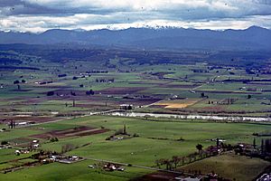
The Motueka River is a cool place in the north of New Zealand's South Island. It's super popular for water sports and fishing! This river flows for about 116 kilometers (72 miles) from the mountains west of Nelson. It heads north and empties into the Tasman Bay.
Contents
Where is the Motueka River?
The Motueka River is about 60 kilometers (37 miles) south of Nelson. It flows for 120 kilometers (75 miles). First, it goes through hilly areas, then flatter land southwest of Tasman Bay. It passes many small towns like Ngātīmoti, Woodstock, Riwaka, and Brooklyn. The river finally flows into Tasman Bay near the town of Motueka. These towns are connected by the Motueka Valley Highway.
What Rivers Flow into the Motueka?
The Motueka River has three main rivers that flow into it. These are the Motupiko River, Wangapeka River, and the Baton River. It also has smaller streams like the Pearse, Dove, Tadmor, and Rainy.
What is the Motueka River Made Of?
The river flows through areas with lots of different rocks. There is a wide band of granite and areas with new alluvium (river deposits). It also has a mix of sedimentary and igneous rocks. These rocks come from the Arthur Range mountains. This mountain range forms the western edge of the river's area. The eastern edge has clay and gravel. Besides granite, you can find many other rock types. These include old basement rock, ultramafic rocks, and both old and new sedimentary rocks.
River Flow and Flooding
The Motueka is a large river. On average, 59 cubic meters of water flow through it every second. But this can change a lot, from 6 to over 2,100 cubic meters per second! The amount of water flowing changes with the seasons. It's highest in winter and spring. The mountain areas to the west and southeast get the most rain. This rain provides most of the water for the Motueka River.
History of Flooding
Big floods used to be a serious problem for people living near the river. A major flood in 1877 caused a lot of damage. It even changed where the river flowed in some places. There were also serious floods in January 1895, July 1929, June 1954, and April 1957. People thought the problem was solved when the Motueka Catchment Control Scheme was finished in 1982. However, in May 2010, the Motueka River flooded 20 homes. This happened in the Wangapeka area near Tapawera, and people had to leave their homes.
Fun Activities on the Motueka River
Fishing for Brown Trout
The Motueka River is very famous for its amazing Brown trout fishing. You can find great fishing spots along the whole river. Many trout live below where the Wangapeka River joins the Motueka. Very large, trophy-sized fish have been caught here!
Watersports and Adventures
The river is also a great place for exciting water sports. You can go rafting, canoeing, or just float down the river on an inner-tube. You can rent kayaks from different companies. There are also organized trips you can join for a fun adventure on the water.
Protecting the Motueka River
Dealing with Invasive Algae
People are working hard to stop the spread of an unwanted algae called Didymosphenia geminata. It's often called 'didymo' or 'rock snot'. This algae grows in warm, shallow water and can form thick mats on the river bottom. It's not harmful to people's health. However, it can affect the homes of fish and their food sources. It can also make water activities less fun. Didymo is considered an invasive species because it spreads easily. Even a single drop of water can carry this tiny algae. So, people who fish must clean their waders and boots very carefully. If they don't, and they move to a different river, they could face a big fine or even prison time.
Integrated Catchment Management Project
The land around the Motueka River is used for many different things. This area is over 2,000 square kilometers (772 square miles). Farmers grow hops, tobacco, Asian pears, and kiwifruit near the river. There are also commercial forestry areas in the lowlands and hills. Farmers also raise sheep and beef, and more and more, dairy cows. Dairy farming means cows often cross the river. This can affect water quality by adding microbes and can cause problems for sports like fishing.
Because of these different land uses, a special research project was started. It was part of a nine-year program that ran from July 2000 to September 2010. The goal was to gather information to help manage the environment of the area. They used an 'Integrated Catchment Management' (ICM) approach. This way of thinking sees the river basin as a whole ecosystem. It also considers social, economic, and political factors that affect the river.
How Clean is the Water?
The Motueka River is quite clean compared to most rivers in New Zealand. Usually, the water quality is good enough for swimming when the river flow is normal.
 | Jackie Robinson |
 | Jack Johnson |
 | Althea Gibson |
 | Arthur Ashe |
 | Muhammad Ali |


