Waiau Toa / Clarence River facts for kids
Quick facts for kids Waiau Toa / Clarence River |
|
|---|---|

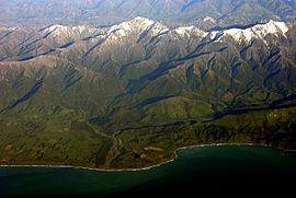
A view over the river mouth near Kaikoura
|
|

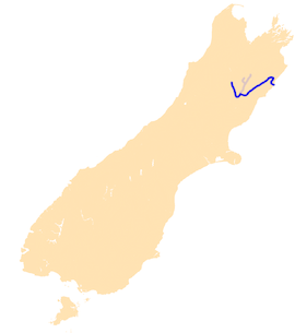
The Waiau Toa / Clarence River system.
|
|
| Native name | Waiau Toa |
| Country | New Zealand |
| Regions | Canterbury, Marlborough |
| Physical characteristics | |
| Main source | Clarence Pass St James Range 42°6′14″S 172°42′58″E / 42.10389°S 172.71611°E |
| River mouth | Pacific Ocean Clarence Sea level 42°10′S 173°57′E / 42.167°S 173.950°E |
| Length | 230 km (140 mi) |
| Basin features | |
| Tributaries |
|
| Waterbodies | Lake Tennyson |
The Waiau Toa / Clarence River is a long river in the northeast part of the South Island of New Zealand. It is about 230 kilometers (140 miles) long. This makes it the eighth longest river in New Zealand.
The river's name, Waiau Toa, comes from the Māori language. It means "River of the Brave Warriors." In 2018, both the Māori name and the English name, Clarence, became official.
River's Journey
The Waiau Toa / Clarence River starts its journey in the St James Range. For its first 50 kilometers (31 miles), the river flows mostly southeast. Then, it turns and heads northeast. It runs through a long, straight valley. This valley is located between the Inland and Seaward Kaikoura Ranges.
After leaving the Seaward Kaikoura Ranges, the river flows through rolling hills. Finally, it empties into the Pacific Ocean. This happens near the small town of Clarence. A big part of the river flows through a large farm called Molesworth Station.
River's Tributaries
Many smaller rivers and streams flow into the Waiau Toa / Clarence River. These smaller rivers are called tributaries. On the left side, some tributaries include the Acheron River and the Dillon River. On the right side, you'll find rivers like the Styx River.
Rocks and History
Some streams that flow into the Waiau Toa / Clarence River cut through special rocks. These rocks are made of limestone and marl. They formed on the seafloor a very long time ago. This was between 75 and 45 million years ago.
These rocks, called the Amuri Limestone, are very important. They help scientists learn about Earth's history. They show us what the climate was like millions of years ago.
2016 Earthquake Event
In 2016, a strong earthquake hit the Kaikoura area. This earthquake caused a large landslide (called a slip). The slip blocked the Waiau Toa / Clarence River. This happened about 10 to 12 kilometers (6 to 7 miles) from where the river meets the ocean.
Water started to build up behind the blocked river. People living downstream from the slip had to leave their homes for safety. About 16 hours later, the river broke through the debris. The water flowed freely again.
See also
 In Spanish: Río Waiau Toa / Clarence para niños
 | Mary Eliza Mahoney |
 | Susie King Taylor |
 | Ida Gray |
 | Eliza Ann Grier |

