Waimakariri District facts for kids
Quick facts for kids
Waimakariri District
|
||
|---|---|---|
|
Territorial authority district
|
||

Council offices in Rangiora
|
||
|
||
 |
||
| Country | New Zealand | |
| Island | South Island (Te Waipounamu) | |
| Region | Canterbury | |
| Communities |
|
|
| Wards |
|
|
| Named for | Waimakariri River | |
| Seat | Rangiora | |
| Towns |
List
|
|
| Area | ||
| • Total | 2,217.12 km2 (856.03 sq mi) | |
| Population
(June 2023)
|
||
| • Total | 69,000 | |
| • Density | 31.12/km2 (80.6/sq mi) | |
| Demonym(s) | Waimakaririan | |
| Time zone | UTC+12 (NZST) | |
| • Summer (DST) | UTC+13 (NZDT) | |
| Postcode(s) |
Map of postcodes
|
|
| Area Code | 03 | |
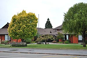
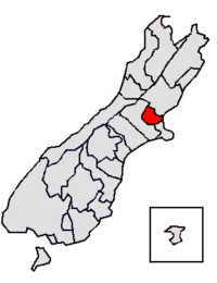
The Waimakariri District is a special area in the Canterbury Region of New Zealand's South Island. It's like a local government area. The district gets its name from the Waimakariri River. This river forms the southern edge of the district. It separates Waimakariri from Christchurch City and the Selwyn District. To the north, you'll find the Hurunui District, and to the east, the big Pacific Ocean.
This district was created on April 1, 1989. It was formed when two smaller areas, Rangiora District and Eyre County, joined together. The Waimakariri District covers about 2,217.12 square kilometres (856.03 sq mi). It is home to 69,000 people. Rangiora is the main town and where the district's government is located. Other important towns include Kaiapoi, Oxford, Pegasus, and Woodend.
The current leader of the district is Mayor Dan Gordon. He was chosen in the local elections held in 2019.
Contents
Exploring Waimakariri: Geography and Towns
The Waimakariri District is located north of the Waimakariri River. This area is part of North Canterbury. The two biggest towns are Rangiora and Kaiapoi. Rangiora is about a 30-minute drive from Christchurch City. Kaiapoi is even closer, about 20 minutes away.
Besides these main towns, there are other smaller towns and beach communities. The district stretches for about 225,000 hectares. It goes from Pegasus Bay in the east all the way to the Puketeraki Range in the west. The Hurunui District is its neighbor to the north.
Main Towns and Communities
The Waimakariri District has five towns with more than 1,000 people. These towns are home to about 64.2% of everyone living in the district.
| Urban area | Population
(June 2023) |
% of district |
|---|---|---|
| Rangiora | 19,600 | 28.4% |
| Kaiapoi | 13,600 | 19.7% |
| Woodend | 4,550 | 6.6% |
| Pegasus | 4,180 | 6.1% |
| Oxford | 2,380 | 3.4% |
Here are some other places and communities in the district:
|
A Look Back: Waimakariri's History
Long ago, before Europeans arrived, the Ngāi Tahu people had important settlements in the Waimakariri District. Their main village was called Taurakautahi, also known as Kaiapoi. Today, a group called Ngai Tuahuriri lives in Tuahiwi, which is north of Kaiapoi. About 8.5% of the district's population today has Māori ancestors. Most of them live in the eastern part of the district.
When Europeans first settled here, Kaiapoi became a busy river port. Rangiora was the main market town for the area. Oxford grew because of its timber mills. Over the years, these towns have changed a lot. This is mainly because the population has grown very quickly.
During the time when New Zealand was a colony, this area was also known as Courtenay. But the Māori name Waimakariri eventually became the official name. The name Waimakariri means 'cold water' in Te Reo Māori. This refers to the river's source, which is snow melting in the Southern Alps.
European settlers liked the rich, flat land for farming. For a long time, most people farmed animals and grew crops. More recently, growing fruits, vegetables, and trees for wood have become important. Today, about 11% of the people working in the district are involved in farming, forestry, and fishing.
Who Lives Here? Waimakariri's Population
The Waimakariri District covers about 2,217.12 km2 (856.03 sq mi). It had an estimated population of 69,000 as of June 2023, . This means there are about 31 people living in each square kilometer.
The number of people living in the district has been growing fast. Experts believe it will keep growing. Even with this growth, Waimakariri still feels like a rural area with small towns. Many residents are part of community groups and enjoy various outdoor activities.
| Ethnicity | Population |
|---|---|
| New Zealand European |
61,008
|
| Māori |
6,546
|
| Pasifika |
1,065
|
| Asian |
2,547
|
| MELAA |
438
|
| Other |
882
|
| Historical population | ||
|---|---|---|
| Year | Pop. | ±% p.a. |
| 1991 | 27,884 | — |
| 1996 | 32,346 | +3.01% |
| 2001 | 36,900 | +2.67% |
| 2006 | 42,834 | +3.03% |
| 2013 | 49,989 | +2.23% |
| 2018 | 59,502 | +3.55% |
| 2023 | 66,246 | +2.17% |
In the 2023 New Zealand census, Waimakariri District had 66,246 people. This was an increase of 6,744 people (11.3%) since the 2018 census. It was also a big jump of 16,257 people (32.5%) since the 2013 census. There were 27,456 homes in the district. The average age was 44.7 years old.
About 17.7% of the people were under 15 years old. About 15.3% were between 15 and 29. The largest group, 45.5%, was aged 30 to 64. And 21.4% were 65 or older.
When it comes to different backgrounds, 92.1% were European/Pākehā. About 9.9% were Māori. There were also 1.6% Pasifika, 3.8% Asian, and 0.7% from the Middle East, Latin America, and Africa. Another 1.3% identified with other backgrounds. Some people chose more than one background.
In the 2018 New Zealand census, Waimakariri District had 59,502 people. There were 22,026 households. The number of males was 29,247 and females was 30,258. This means there were slightly more females than males.
About 17.6% of people were born outside New Zealand. This is lower than the national average of 27.1%.
Many people (53.9%) said they had no religion. About 36.0% were Christian. Smaller numbers followed Māori religious beliefs (0.3%), Hindu (0.3%), Muslim (0.2%), Buddhist (0.2%), or other religions (1.5%).
For people aged 15 and older, 14.7% had a university degree or higher. About 20.9% did not have any formal qualifications. The average income was $33,600. This was a bit higher than the national average of $31,800. About 18.0% of people earned over $70,000.
Regarding jobs, 49.8% of people aged 15 and older worked full-time. Another 16.2% worked part-time. About 2.7% were unemployed.
| Name | Area (km2) | Population | Density (per km2) | Households | Median age | Median income |
|---|---|---|---|---|---|---|
| Oxford-Ohoka Ward | 1,619.81 | 12,051 | 7.44 | 4,254 | 43.2 years | $37,700 |
| Rangiora-Ashley Ward | 443.29 | 24,915 | 56.20 | 9,354 | 44.3 years | $31,400 |
| Kaiapoi-Woodend Ward | 154.02 | 22,530 | 146.28 | 8,415 | 43.0 years | $34,200 |
| New Zealand | 37.4 years | $31,800 |
Waimakariri's Economy: How People Make a Living
Much of the Waimakariri District has flat, fertile land. There are also gently rolling hills that are very productive. Some land east of Rangiora used to be swampy. It can still have poor drainage and sometimes floods.
The northwestern part of the district has hills and high country. Mountains like Mt Oxford, Mt Richardson, Mt Thomas, and Mt Grey stand tall in the western landscape.
In the past, farming animals and growing crops were the main ways people made a living. There weren't many big factories. More recently, many smaller farms have started. Some of these are used for growing vegetables, flowers, and trees.
The district has a few larger industries. There's a big factory in Sefton that makes fibreboard from local wood. Other businesses are mostly smaller services and processing companies. Some of these also use wood from the area.
Waimakariri District has excellent ways to connect with other places. The main railway line for the South Island and State Highway 1 both pass through the eastern part of the district. There's also an airfield in Rangiora. Plus, it's close to the Christchurch International Airport. Communication systems like phones and internet are always being improved.
Fun and Games: Recreation in Waimakariri
The Waimakariri District offers many ways to have fun! You can find sandy beaches, river mouths (estuaries), deep river valleys (gorges), and rivers with many channels (braided rivers). These places are great for fishing, boating, and rafting.
The famous Waimakariri River is perfect for jet boating, kayaking, and fishing. Beautiful sandy beaches are also nearby. You can also enjoy sailing on Pegasus Lake. Horse riding and farm tours are popular activities. Don't forget the weekly farmers' markets for fresh local produce!
The foothills and mountains offer different kinds of tramping (hiking) adventures. There are also more and more walking trails and special recreation areas throughout the district.
Learning in Waimakariri: Education
The Waimakariri District has 20 state-run primary schools. It also has three state-integrated primary schools. These schools are supported by the government but also have a special character, often religious. There are two area schools that teach students from Year 1 to Year 13. One is in Oxford and the other is Rangiora New Life in Rangiora.
For older students, there are two secondary schools: Rangiora High School and Kaiapoi High School. Many primary schools get a lot of support from their local communities. More and more preschools are also opening in the district.
 | Ernest Everett Just |
 | Mary Jackson |
 | Emmett Chappelle |
 | Marie Maynard Daly |


