Eyrewell Forest facts for kids
Quick facts for kids
Eyrewell Forest
|
|
|---|---|

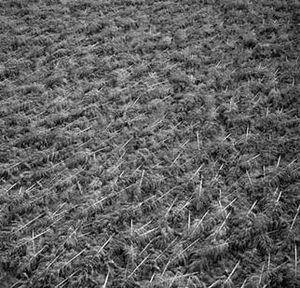
Destruction of the forest the area is named after on 1 August 1975
|
|
| Country | New Zealand |
| Region | Canterbury |
| Territorial authority | Waimakariri District |
| Ward | Oxford-Ohoka Ward |
| Community | Oxford-Ohoka Community |
| Electorates |
|
| Area | |
| • Total | 272.11 km2 (105.06 sq mi) |
| Population
(June 2023)
|
|
| • Total | 2,070 |
| • Density | 7.607/km2 (19.70/sq mi) |
| Time zone | UTC+12 (NZST) |
| • Summer (DST) | UTC+13 (NZDT) |
| Postcode |
7476 and 7495
|
| Area code(s) | 03 |
| Local iwi | Ngāi Tahu |
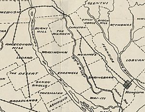
Eyrewell Forest is a quiet countryside area in the Waimakariri District of New Zealand. It's known for its history with trees and its unique wildlife.
Contents
What's in a Name? The Story of Eyrewell
The name "Eyrewell Forest" has an interesting history. In the 1920s, native kānuka trees were replaced with planted forests.
How "Eyre" Got Its Name
The first part of the name, "Eyre," comes from Edward John Eyre. He was a leader in New Zealand from 1848 to 1853. Many places in the area are named after him.
The "Well" and "Forest" Parts
The "well" part of Eyrewell was added by an early settler, Marmaduke Dixon. He found important groundwater on his land. The "Forest" part comes from the fact that about half of the area was covered in planted pine trees.
Eyrewell Forest: A Look at Its Past
In the early 1900s, there weren't many native forests in Canterbury. So, the government decided to plant new forests, including the one at Eyrewell.
The Great Wind of 1975
On August 1, 1975, strong winds blew through the area. Most of the forest was knocked down. This was a big event for Eyrewell Forest.
The Eyrewell Ground Beetle's Home
The Pinus radiata (pine) trees in the forest were once the only known home for a very rare insect. This insect is called the Eyrewell ground beetle. It was critically endangered, meaning it was at high risk of disappearing forever.
Changes to the Land
By January 2019, most of the pine forest was cleared. This was done by the local iwi (Māori tribe) Ngāi Tahu. Their plan was to turn the land into large dairy farms.
Concerns for Nature
The Department of Conservation was worried about these changes. They feared the rare Eyrewell ground beetle might become extinct. There are also concerns about how the new farms might affect the environment. This includes the nearby Waimakariri River and the dry conditions of the area.
Who Lives in Eyrewell? Population Facts
The Eyrewell area covers about 272 square kilometers. As of 2023, it has an estimated population of 2,070 people.
Population Growth Over Time
| Historical population | ||
|---|---|---|
| Year | Pop. | ±% p.a. |
| 2006 | 918 | — |
| 2013 | 1,521 | +7.48% |
| 2018 | 1,806 | +3.49% |
In 2018, Eyrewell had 1,806 residents. This was a good increase from previous years. The population grew by 18.7% since 2013 and almost doubled since 2006.
People and Households
There were 627 households in Eyrewell in 2018. The number of males and females was almost equal. The average age of residents was about 38.4 years old.
Age Groups in Eyrewell
- About 22% of people were under 15 years old.
- Around 16% were between 15 and 29 years old.
- More than half, about 53%, were aged 30 to 64.
- About 8% were 65 years or older.
Different Backgrounds
Most people in Eyrewell are of European or Pākehā background (90.9%). There are also people from Māori (9.1%), Pasifika (1.3%), and Asian (4.8%) backgrounds. Some people identify with more than one ethnicity.
Where People Are Born
About 22% of Eyrewell residents were born outside New Zealand. This is a bit lower than the national average for New Zealand.
Religious Beliefs
When asked about religion, many people (59%) said they had no religion. About 30% were Christian. Smaller numbers followed Māori religious beliefs, Hinduism, Islam, Buddhism, or other religions.
Eyrewell's Weather: A Climate Overview
Eyrewell Forest has a mild climate. The average temperature in summer is about 16.2°C. In winter, the average temperature is around 5.9°C.
Monthly Temperatures
Here's a table showing the normal average temperature for each month:
| Month | Normal temperature |
|---|---|
| January | 16.8 °C |
| February | 16.3 °C |
| March | 14.6 °C |
| April | 11.6 °C |
| May | 8.3 °C |
| June | 5.8 °C |
| July | 5.3 °C |
| August | 6.5 °C |
| September | 8.9 °C |
| October | 11.2 °C |
| November | 13.3 °C |
| December | 15.5 °C |
| Climate data for Eyrewell Forest (1981–2010) | |||||||||||||
|---|---|---|---|---|---|---|---|---|---|---|---|---|---|
| Month | Jan | Feb | Mar | Apr | May | Jun | Jul | Aug | Sep | Oct | Nov | Dec | Year |
| Mean daily maximum °C (°F) | 23.3 (73.9) |
22.5 (72.5) |
20.7 (69.3) |
18.0 (64.4) |
14.2 (57.6) |
11.8 (53.2) |
10.7 (51.3) |
12.4 (54.3) |
14.9 (58.8) |
17.0 (62.6) |
19.3 (66.7) |
21.3 (70.3) |
17.2 (62.9) |
| Daily mean °C (°F) | 16.9 (62.4) |
16.2 (61.2) |
14.4 (57.9) |
11.7 (53.1) |
8.7 (47.7) |
6.1 (43.0) |
5.3 (41.5) |
6.8 (44.2) |
9.0 (48.2) |
11.0 (51.8) |
13.1 (55.6) |
15.3 (59.5) |
11.2 (52.2) |
| Mean daily minimum °C (°F) | 10.6 (51.1) |
10.0 (50.0) |
8.1 (46.6) |
5.3 (41.5) |
3.1 (37.6) |
0.4 (32.7) |
0.0 (32.0) |
1.1 (34.0) |
3.0 (37.4) |
5.1 (41.2) |
6.9 (44.4) |
9.2 (48.6) |
5.2 (41.4) |
| Average rainfall mm (inches) | 56.8 (2.24) |
54.4 (2.14) |
71.9 (2.83) |
59.1 (2.33) |
69.5 (2.74) |
60.2 (2.37) |
76.9 (3.03) |
76.4 (3.01) |
56.7 (2.23) |
79.4 (3.13) |
51.0 (2.01) |
66.5 (2.62) |
778.8 (30.68) |
| Source: NIWA (rain 1971–2000) | |||||||||||||
 | Delilah Pierce |
 | Gordon Parks |
 | Augusta Savage |
 | Charles Ethan Porter |


