Hurunui District facts for kids
Quick facts for kids
Hurunui District
|
|
|---|---|
|
Territorial authority district
|
|

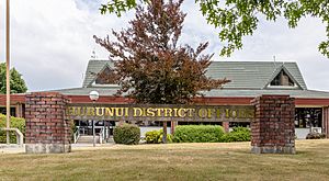
Hurunui District Offices in Amberley
|
|

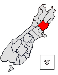
Location of the Hurunui District within the South Island
|
|
| Country | New Zealand |
| Region | Canterbury |
| Wards |
|
| Formed | 1989 |
| Seat | Amberley |
| Area | |
| • Total | 8,640.96 km2 (3,336.29 sq mi) |
| Population
(June 2023)
|
|
| • Total | 13,800 |
| • Density | 1.597/km2 (4.136/sq mi) |
| Time zone | UTC+12 (NZST) |
| • Summer (DST) | UTC+13 (NZDT) |
| Postcode(s) |
Map of postcodes
|
The Hurunui District is a special area in the Canterbury Region of New Zealand. It's on the east coast of the South Island, just north of Christchurch. This district stretches all the way from the coast to the mountains, covering a huge area of about 8,641 square kilometers.
Contents
People Living in Hurunui District
The Hurunui District is quite large, covering about 8,641 square kilometers. As of 2023, about 13,608 people live here. This means there are only a few people per square kilometer, making it a very open and spacious place.
The number of people living in Hurunui has been growing steadily:
- 2006: 10,476 people
- 2013: 11,529 people
- 2018: 12,558 people
- 2023: 13,608 people
Who Lives in Hurunui?
In the 2023 census, 13,608 people lived in the Hurunui District. This was 1,050 more people than in 2018. The average age of people living here was 46.2 years old.
Here's a look at the different groups of people in Hurunui:
- 17.7% were under 15 years old.
- 13.3% were between 15 and 29 years old.
- 46.5% were between 30 and 64 years old.
- 22.5% were 65 years or older.
Most people (90.5%) are of European or Pākehā background. Other groups include Māori (10.1%), Pasifika (1.3%), and Asian (4.7%). Some people identify with more than one group.
Many people in Hurunui (52.5%) said they had no religion. About 36.6% were Christian. Smaller numbers followed other religions like Māori religious beliefs, Hindu, Muslim, or Buddhist.
Towns and Communities
The Hurunui District has two main towns with populations over 1,000: Amberley and Hanmer Springs. These two towns are home to a large part of the district's population.
Here are some of the main towns and their populations (as of 2018):
| Urban area | Population | % of district |
|---|---|---|
| Amberley | 2,380 | 17.2% |
| Hanmer Springs | 1,140 | 8.3% |
| Leithfield | 620 | 4.5% |
| Leithfield Beach | 420 | 3.0% |
| Culverden | 370 | 2.7% |
| Cheviot | 360 | 2.6% |
| Waipara | 320 | 2.3% |
| Waiau | 270 | 2.0% |
| Waikari | 270 | 2.0% |
| Hawarden | 230 | 1.7% |
Other Places to Explore
The Hurunui District is made up of many smaller towns and localities. These are grouped into different wards (areas managed by local council members).
- East Hurunui Ward:
- Cheviot Sub-Division:
- Glenmark Sub-Division:
- Greta Valley
- Motunau
- Motunau Beach
- Omihi
- Scargill
- Spye
- Waipara
- Stonyhurst
- Davaar
- West Hurunui Ward:
- Amuri Sub-Division:
- Balmoral
- Culverden
- Mount Lyford
- Mouse Point
- Pahau
- Rotherham
- Waiau
- Cheddar Valley
- Greenbrae
- Ngawiro
- Red Post Corner
- Woodchester
- Marble Point
- Hurunui Sub-Division:
- Hawarden
- Horsley Down
- Hurunui
- Masons Flat
- Medbury
- Pyramid Valley
- The Peaks
- Virginia
- Waikari
- Weka Pass
- Lake Sumner
- Hanmer Springs Sub-Division:
- Boyle Village
- Hanmer Springs
- Lewis Pass
- Engineers Camp
- Amuri Sub-Division:
- South Hurunui Ward:
- Amberley Sub-Division:
- Amberley
- Amberley Beach
- Balcairn
- Broomfield
- Glasnevin
- Leithfield
- Leithfield Beach
- Greneys Road
- Teviotdale
- Amberley Sub-Division:
 | Jackie Robinson |
 | Jack Johnson |
 | Althea Gibson |
 | Arthur Ashe |
 | Muhammad Ali |

